- pg. 1
GEOGRAPHY PAPER 1 (250/1) BY KITONSA RONALD
1.0 CONTINENTAL DRIFT AND THE DISTRIBUTION OF CONTINENTS AND OCEAN BASINS
Continental drift is a hypothesis that states that continental land masses have changed their
relative position as a result of fragmentation and moving apart of the original land masses.
It is believed that continents are mobile, that they drifted from their original positions and are
still moving even today.
Several theories have been put forward in an attempt to explain the apparent movement of
continents which resulted from the fragmentation by rifting, followed by drifting apart of
individual masses of the broken out cells / land masses to form the present day continents and
ocean basins.
1.1F.B TAYLOR’S THEORY
According to Taylor, originally the earth had two land masses called Laurasia and
Gondwanaland.
Laurasia was located near the present day north pole from where it drifted southwards towards
the Equator.
Gondwanaland on the other hand was located somewhere near the South Pole and it also drifted
but this time northwards towards the Equator.
Taylor explained the force that caused the movements in terms of the moon’s gravitational pull
and tidal attraction. He believed that the moon came very close to the earth and exerted an
enormous gravitational pull that caused Laurasia and Gondwanaland to move towards the
equator away from their positions near the poles.
This movement is believed to have taken place sometime in the crustaceous period about 135-
70 million years.
When there was resistance to this outward flow the crust would flow outwards and bulge up to
Form Mountains.
In some cases, the crust stretched and split forming troughs that became ocean basins.
Taylor suggested that the basin of the Atlantic and Indian Ocean were left behind between
drifting continents.
When Laurasia and Gondwanaland finally collided they formed Fold Mountains e.g. the Atlas in
North Africa and Alps in Southern Europe.
- pg. 2
WEAKNESSES OF TYLOR’S THEORY
Taylor did not explain why the moon came close to the earth.
It is highly doubted that the moon could ever exert enough force to pull the huge land masses
(continents as they are known today).
If at all the moon came closer and exerted such a strong force, the earth’s rotation would have
stopped within 1year but the fact that the earth’s rotation continued throughout the present day
makes Taylor’s theory doubtable.
Taylor does not explain the formation of earlier fold mountains like Caledonian system of the
Siluro- Devonian times the Hercynian system of the Mid-Permian and Carbonferous periods and
the Apeladian.
1.2 ALFRED WEGNER’S THEORY OF CONTINENTAL DRIFT
He was a German meteorologist who was the 1
st
to suggest that continents had changed their
positions overtime. This led to what is now known as Wegner’s theory of continental drift.
According to his theory, the present day continents originated from one Giantic sialic land mass,
a super continent known as Pangaea.
Pangaea was located near the present day south pole and was surrounded by huge ocean or
water body known as Panthalassa.
During the pre-Cambrian period to the permian time (about 250 million years b.p). Pangaea
began drifting northwards.
Pangea broke into two super continents known as Laurasia and Gondwanaland.
The two continents were separated by a narrow water body known as the “sea of Tethys”.
Laurasia drifted northwards across the equator while Gondwanaland remained in the south near
the South Pole.
During the late Paleozoic and early Mesozoic eras. Numerous cracks developed in the land
masses leading to the separation and consequent drifting.
Finally during the Crustaceous period (approximately 135-70million years ago). The land
masses completely broke up.
Gondwanaland gave rise to the southern continents namely Africa, South America, Antarctica,
Australia, sub-continent of India and numerous islands.
Laurasia broke up to give rise to North America, Europe, Asia, Greenland, Iceland, UK e.t.c.
In the north Eurasia drifted eastwards while North America drifted westwards.

- pg. 3
In the South Africa moved to attain its present position astride the equator.
India drifted northwards to join Eurasia land mass. South America drifted westwards and then
northwards towards the equator to join North America through the Panama Canal.
Australia drifted eastwards away from Antarctica approximately 65 million years B.p.
According to Wegner the northward drift was due to the gravitational attraction of the
Equatorial bulge called centrifugal force while the westward drift was due to the tidal attraction
of the sun and moon.
During the drifting, the oceans between continental blocks became wider forming the present
day ocean basins.
Wegner contends that the Himalayas were formed when the Indian sub-continent collided with
the Asian land mass thus forming a fold mountain with former ocean sediments on top.
CRITICISMS OF WEGNER’S THEORY
His theory has been criticized on the basis that in as much as the equatorial centrifugal force
exists, it is too weak to drag continents from their polar positions.
His theory does not explain what caused the continents to separate or to crack extensively
before drifting.
Wegner was a meteorologist and not a geologist. So he did not have enough geological
knowledge over which to come up with his theory.
He does not explain the forces which he suggested that were responsible for the drifting of the
continents from their original positions.
Note: In as much as Wegner’s theory had shortcomings, it was exciting and was later
adopted by many scholars and geologists.

- pg. 4
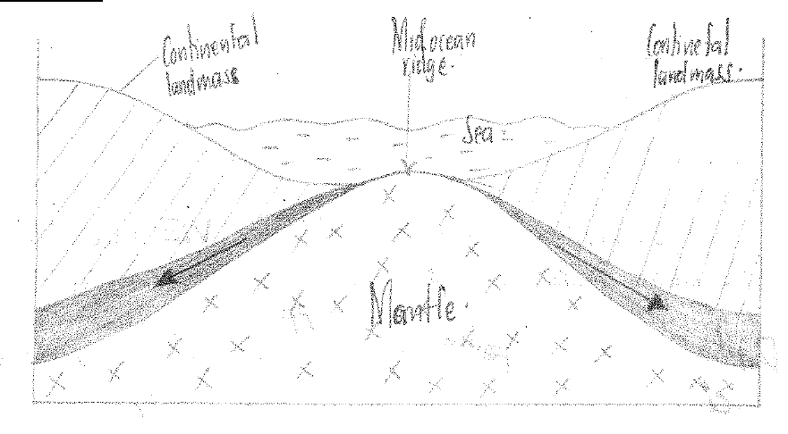
1.3 THE SEA FLOOR SPREADING THEORY
Diagram:
This is one of the modern and more scientific theories of continental drift, it was put forward by
an American geologist called H..Hess in the 1960s.
He forwarded this theory after studying the sea bed of the Atlantic Ocean in which he observed
the presence of ridges between Africa and America.
According to H.Hess, the interior of the earth is in a molten/semi-fluid state because of the
intense heat resulting from radio-activity and geochemical reactions. These molten rocks are
highly mobile and therefore tend to rise from the mantle in form of convective currents.
- pg. 5
These move in a circular motion and as they reach the base of the earth’s crust, they flow
horizontally and exert a drag force on the crust to move in their direction of flow. This causes
movement of continents or crustal layer, hence continental drift.
After studying the mid ocean ridges, he established that when the convective currents
approached this region, they deposited new rocks which displaced/pushed away the older
rocks, a fact that shows that the sea floor is spreading apart.
He was further convinced after realizing that as the distance away from the mid ocean ridge
increased, the rock age increased as well, a fact portraying mobility/expansion of the ocean each
time new rocks are deposited.
- pg. 6
1.4 PLATE TECTONIC THEORY
PLATE TECTONICS
The Plate Tectonics Theory came up as a result of investigating the Sea Flow Spreading
Theory which showed that parts of the crust were being sub ducted and destroyed e.g.
along the edges of the Pacific ocean or basin.
This is the most modern theory put forward to explain the theory of continental drift. Plate
tectonics is the theory put forward to explain the movement and distribution of the present day
continents and the ocean basins and the resultant landforms.
The theory assumes that the crust is divided into a series of tectonic plates or raft or a blocks, six
major and about 12 minor.
The major plates include:-
- Indian plate
- Pacifican plate
- African plate
- Eurasia plate
- Atlantic plate
- American plate
He asserted that the plates are rigid and mobile. They move because of the energy generated by
radio-activity and geochemical reactions in the interior of the earth. The resultant heat causes
partial melting of rocks which then rise up in form of convective currents and drive the plates.
The movement of the tectonic plates is assisted by plate boundaries or margins i.e. constructive,
destructive and conservative.
As the plates move so do continents following the direction of plates movement. There are types
of movement caused by convective currents that affect the distribution of continents.
(i) Divergent movements
These causes rifting of the crust and consequent outward movement of the continent. In
the process, ocean basins characterized by mid-ocean ridges and islands are formed e.g.
the mid-Atlantic ridge as it was the case for South America and Africa.
- pg. 7
Divergent plate Boundary
(Diagram)
(ii) Convergent plate boundary.
These push continents towards each other e.g. continents may move towards each other,
getting closer and in the process, sediments are folded to form fold mountains e.g when
India moved towards Asia, forming Himalayas.
Continents may move towards ocean plates, causing sub-duction of the denser simatic
rocks. This is assimilated in the mantle forming trenches and volcanic mountains e.g.
where South America plate moved against the Nazica plate,Nazica trench and Andes
formed. Ocean crust may move towards each other. This causes narrowing of ocean
basins and continents move nearer. In the process, trenches and volcanic arcs form e.g.
Pacific and Eurasian plates have led to the formation of Marianna trench and Japan arc.

- pg. 8
The convergent plate boundary
(Diagram)
(iii) Transformation movements (Conservative boundary)
These involve plates moving towards each other without causing a collision or diversion.
In the process they offset sections of continents, ridges and trenches e.g. North American
plate against the pacific plate forming the San Andreas Fault, causing off/setting off land
to the West.
NOTE: The drifting apart of tectonic plates with in the earth’s crust, resulted into
formation of various relief landscape features or landforms e.g. in East Africa, the drifting
of tectonic plates set in motion tectonic movement e.g. faulting, volcanicity forming
crustal warping.
(Diagram)
All the above tectonic plates facilitated the formation of various landforms as will be seen later.
Qn. (a) What is meant by plate tectonics?
(b) How does the theory of plate tectonics explain the present day distribution of
continents (2005 UNEB)
Land masses
Land masses
movements
- pg. 9
1.5 EVIDENCE TO SUPPORT / JUSTIFY CONTINENTAL DRIFT
(i) The jig-saw or Visual fit theory
The present shape of the present land masses is such that most of them have shapes that
can fit in each other. If forced to come close to each other e.g. the east coast of South
America and West coast of Africa, can accurately fit in each other not only at the surface
but also at a depth of 2000m. Such is evidence that Africa and South America were once
one land mass that was separated.
The coast of Africa, India, Antarctica and Australia can also fit. Arabia fits accurately in the
North Eastern part of Africa.
(ii) Geometrical fit
This is related to the jigsaw fit. According to the west coastline of Africa and the eastern
coastline of South America fit almost exactly on each other. If rotated through an angle of
57
o
with rotational points at 40
o
N and 30
o
W.
(iii) Matching Geology or Similar Rocks
There is a close similarity in the rocks of South America and North Africa. There is a
convincing boundary joining between Accra in Ghana and Sao Louis in Brazil. They both
have rocks rich in manganese. Similarly the Gold bearing rocks of West Africa in Ghana
are similar to those in Guyana in South America. Oil beds of Brazil are also similar to
those of Angola in Africa.
(iv) Matching of Orogenic zones
The alignment of belts of Fold Mountains matches across the joint of Africa and South
America.
(v) Glacial evidence
Carboniferous glacial deposits exist in tropical and sub-tropical low lands such as Congo
basin and in South America. The existence of such deposits in the hot tropical region is
proof that land masses at one time were positioned in the cooler latitudes where glacial
conditions existed. Similarly, thick deposits of till, a fossilized rocks, glacial moraine in
Eastern Brazil. Paraguay and Argentina are similar to those of southern Africa and
Australia, a fact that suggests that the continents at one time were too close.
(vi) Similar sedimentary rocks
Research has shown that along parts of North Eastern Brazil coast, Nigeria and
Cameroon, similar sedimentary rock sequences exist in the lower beds of those basins,
match exactly on both continents.
(vii) Coral reefs in temperate regions today
Coral reefs only grow in tropical regions where temperatures are as high as 20
o
C. Their
existence in cold temperate conditions like in Greenland, North America and Britain is
- pg. 10
enough evidence that, these regions were once positioned in the tropical regions where
conditions were favorable for the growth of coral reefs.
(viii) Occurrence of lateritic soils
In temperate regions in North America and Europe proves that those continents at one
time experienced tropical climatic conditions favorable for the formation of lateralites
but with time drifted to the temperate regions.
(ix) Similarity of vegetation and Animals
On different continents which seem to have been attached to each other proves the
theory of continental drift e.g. the S. American tropical rainforests and West African
tropical rainforests which were split by continental drift.
(x) The presence of petroleum in the Middle East which is mainly a desert area suggests
that the existence of minerals (Petroleum) in the area is due to the effect of continental
drift. This is due to the fact that Petroleum and Coal are products of thick vegetation yet
the Middle East does not have a climate that supports thick vegetation growth.
(xi) The existence of salt evaporates in cold parts of U.S.A, Britain; Russia is evidence for
continental drift such evaporates are only found in hot tropical regions. Their formation
is associated with evaporation of water from salt solution.
(xii) The presence of Fold Mountain proves continental drift; Fold Mountains are formed by
collision of tectonic plates during continental drift. As a result, the overflying rocks folded
to form fold mountains e.g. the Himalayas, Alps e.t.c.
(xiii) The existence of large ocean basins, continents, tremours and earthquakes proves that
the earth is in the process of drifting. Hence leading to the continuous crustal instabilities.
(xiv) Existence of a rift valley
About 300 years million ago, the East African rift valley didn’t exist but it gradually
developed as a result of the earth’s instability due to continental drift. In fact the valley
developed as a result of compressional and tensional forces.
(xv) Evidence of sea floor spreading.
Recent studies of ocean and sea floors reveal that oceans and seas have been expanding
over the years. This is probably because of the apparent movement of the continents
evidenced by the sea floor spreading e.g. the Red sea has increased from 0-300km wide in
the last million years. And the Atlantic Ocean is also believed to be enlarging. On the other
hand some sea floors are contracting and this is leading to the reduction in ocean basins
or trenches. This is due to tectonic plates moving towards each other due to continental
drift e.g. the Pacific Ocean is contracting and the Peruvian plain is narrowing due to the
movement of continents.
Similarly, the Mediterranean Sea is also said to be reducing in size because of continental
drift.
(xvi) The proximity of continents to the North Pole than the south poles proves continental
drift. That continent moved northwards from the southern hemisphere.
- pg. 11
(xvii) Paleomagnetism Evidence / Theory
This refers to the study of rock magnetism at the time of rock formation. This is based on
the fact that igneous rocks which contain iron when cooled retain some magnetism.
When igneous activities take place, iron bearing rocks are permanently magnetized in
accordance with the earth’s magnetic fields.
Studies of paleo-magnetic rocks in Australia, India, North and South America show that
those rocks no longer point in the North to South directions. The reason is that continents
might have been dislocated relative to their present positions.
Rock magnetism of South America e.g. has been dislocated through 17
o
and indicates
North East as their true North. This shows that continents have been drifting.
1.6 CRITICISMS OF CONTINENTAL DRIFT
Some geographers have disagreed and criticized the continental drift by disagreeing with
Wegner’s evidences. Some Geographers argue that continents have not been drifting. Instead
different geomorphic processes have contributed to the shaping of earth the way it is. Such
geographers argue that;
(i) Some of the causes said to be responsible for breaking of Pangaea are vague. The moon’s
force of attraction (the big bang theory) could not have caused the splitting of Pangaea
since the moon’s force of attraction is not so high. Besides the moon is much smaller than
the earth and its pressure could not lead to the splitting of Pangaea.
(ii) The spreading of ocean floors might be due to continuous erosion and weathering on the
main land which make the ocean appear as it expanding or the contraction of the seas and
oceans is due to isostatic adjustments because of compressional forces within the earth’s
crust, could be the ones forcing oceans appear like reducing in size. If this is true, then
theory of continental drift is a myth rather than a reality.
(iii) The existence of similar rocks on different continents and identical animals and
vegetation on the different continents opposite each other, might not be because of
continental drift but because of such regions being found in the same climatic belt e.g.
Amazon and Congo rocks are exposed to the same weathering processes and that’s why
they are similar.
Tropical rainforests in Congo and Amazon basins are similar because they are both found
in the equatorial region with heavy rainfall.
(iv) The existence of peri glacial rocks along the equator in the Congo and Amazon basins,
might be probably because there existed very high mountains along the equator in the
remote past but not because of continental drift.
(v) The presence of coral reefs in Greenland might be due to the world’s changing climatic
conditions but not because of continental drift. It is probably true that in the past
temperate conditions could favour coral growth, which led to the formation of coral reefs.
- pg. 12
But with time, climatic conditions of Greenland have changed and it is no longer possible
for coral polyps to grow.
(vi) The presence of petroleum and coal in the Middle East, a present day desert, is a result of
climatic changes.
Inspite of the criticisms of continental drift, it should be understood that continental drift is a
reality and it may continue taking place for ages to come.
ROCKS IN EAST AFRICA.
A ROCK is an aggregate of mineral particles forming parts of the earth’s crust. (Lithosphere).
Some rocks however consist single minerals like diamond, gold, quartz while others are
composed of a complex combination of mineral elements like sodium (Na), Mica (Mi.).
Rocks of the earth’s crust are mainly made up of eight(8) elements which include; Potassium(k),
Oxygen(O2), Sodium (Na), Aluminum (Al), Silicon(Si) Calcium(Ca), Iron(Fe) and
Magnesium(Mg).
A mineral therefore refers to an organic substance which occurs naturally in the earth’s crust
and made up of chemical elements. The minerals can be crystalline or powdered in nature and
maybe of different chemical composition in different colors.
CLASSIFICATION OFROCKS
There are 3 major types of rocks;
Sedimentary rocks
Igneous rocks
Metamorphic rocks
IGNEOUS ROCKS
The word igneous is derived from a Greek word “Ignis” which means fire. Therefore igneous
rocks are fire formed rocks and their formation is associated with volcanicity.
Origin:
They are formed as a result of Vulcanicity.
They are formed by cooling and solidification of molten materials (magma) caused by intensive
heat resulting from the radio activity and geochemical activities within the core.
Because of the heat, convectional current are set off within the mantle creating lines of
weaknesses called cracks, vents or fissures develop through which molten materials pass before
cooling and solidifying.
- pg. 13
Igneous rocks are usually crystalline in nature and they do not contain fossils. The size of the
crystals depends on the rate of cooling and where the cooling takes place.
CHARACTERISTICS OF IGNEOUS ROCKS.
They are fire formed rocks
They are crystalline in nature
They are non-fossilled
Some are hard e.g. granite ant others are soft e.g. pumice.
Some are light colored e.g. obsidian while others are dark colored like Gabbro
Some are formed in or within the earth’s surface while others are on the earth’s surface
Igneous rocks are classified into two ways;
According to the mineralogical content.
According to the level of cooling and solidification.
Under mineralogical composition, there are those which are classified to the Silica content of
magma.
1. Acidic Igneous Rocks
These have high percentage of Silica (over 65%).
They are light colored with low density.
They are delivered from highly viscous magma e.g. obsidian, Andesite, Granite and pumice.
2. Basic igneous rocks.
They are dominated by iron and magnesium.
They are dark colored with high density delivered from very fluid lava that easily flow over a
long distance before cooling.
They have a very low silica content of less than 45% e.g. Gabbro, Dolomite and Basalt.
3. Ultra-basic Igneous Rocks
These are rocks with an average silica content of about 55% and they are relatively viscous.
They are medium in size with moderate density e.g. Quartz, Porphyry.
- pg. 14
According to the level of cooling and solidification, the formation of different igneous rocks
depends on the cooling rate of magma and circumstances under which takes place. This forms
different types of rocks in different sizes and different depth and these include; Volcanic/
exclusive rocks, Hyperbysal rocks, plutonic rocks.
1 Volcanic/ Extrusive Rocks.
When magma cools and solidifies onto the earth’s surface, exclusive igneous rocks are formed.
And this is because the cooling rate of magma is very fast and crystals are formed and they are
very small in size.
They are light colored with low density e.g. Obsidian near Nakuru in Kenya, Andesite, Rhyolite,
Basalt, Pumice etc.
These can be seen near Kenya highlands, Kisoro lava plateau in South West Uganda.
2 Hyperbysal Rocks
These are rocks that are formed when magma cools and solidifies inside the earth’s crust but at
the shallow depth of the earth’s surface. This is because magma fails to reach the earth’s surface
because of its medium cooling rate forming the medium sized crystals of moderate density like
Quartz, feldspar, porphyry and dolerite.
3 Plutonic rocks (Abyssal)
These are rocks that are formed when magma cools and solidifies inside the earth’s crust but at a
very great depth of the earth’s surface.
They are described as deep seated rocks because of their formation at great depth.
The magma that forms such rocks is extremely slow and crystals formed tend to be large in size
with a very high density e.g. Granite, Gabbro, dolerites.

- pg. 15
A TABLE SHOWING THE SUMMARY OF IGNEOUS ROCKS
Types of
igneous rocks
Where it is
formed
Cooling
rate
Characteristics
Examples
Volcanic
Earth’s surface
Very fast
Light colored
Fine grained
High density
Andesite
Obsidian
Pumice
Basalt
Hyperbysal
Inside the
earth’s surface
but shallow
Medium
Moderate
density
Medium size crystal
Quartz
Porphyry
Feldspar
Dolerite
Plutonic
(Abyssal)
Inside the
earth’s surface at
great depth
Very slow
Low density
Large size
Dark color
Granite
Gabbro
Synite
Influence of igneous Rocks on land forms development in east Africa
Igneous rocks are found in areas of extrusive and intrusive volcanic activities. They have
influenced land forms development in East Africa in the following ways;
When exposed, igneous rocks form areas of high relief and depressions e.g. intrusive volcanicity
is associated with highlands of Eastern and Western areas of East Africa. E.g. Mt. Elgon,
Kilimanjaro, Muhavura, Abe dare ranges, the Mau ranges.
Intrusive volcanicity is associated with inselbergs granite tors, exfoliation domes etc. scattered
in the various parts of East Africa e.g. Nakasongola, Mombasa, Soroti e.tc.
1. Thalloids.
Igneous rocks form thalloids which are sometimes called wizard Islands. It is a circular and
round volcanic feature made of viscous magma that builds into a Crater Lake depression or
caldera.
It is formed on top of Mountain Rungwa in Tanzania.
- pg. 16
2. A cumulo-Dome
This is a circular, round, steep sided dome shaped feature deep rooted into the earth’s surface. It
is formed when volcanic activity builds up a volcanic dome of viscous magma that builds into
after the extrusion of magma on a high rate of pressure. The surface quickly hardens while the
interior is still fluid.
Further up rising within the already hardened layers forces the dome to expand outwards
forming a more or less rounded feature called a cumulo-dome e.g. Nutumbi hills.
2. A volcanic Plug.
Igneous rocks have also led to the formation of a volcanic plug and these are very steep sided
volcanic features that stand prominently above the ground.
It is formed when very viscous magma is extruded out the earth’s crust as a cylindrical mass a
midst the clouds of ash, cinders and fluid magma.
The solidification onto the earth’s surface of the ejected steep sided ridge shaped feature leads to
the formation of a volcanic plug .e.g. the Tororo rock, Mawenzi peak on mountain Kilimanjaroetc.
Diagram
- pg. 17
4. Larva Plateau
Igneous rocks which have got a low silica content have developed as larva plateau.
This is upland or raised land with more or less mountainous relief characterized with the steep
slides. It is formed by the different successive layers of larva extruding through the different
lines of weaknesses called fissures.
These form different layers of lava flowing for long distances solidifying to form a larva plateau.
Diagram
5. Basalt domes
Igneous rocks have also formed basalt domes/ shield volcano. This is a generally low and broad
volcano with concave sides e.g. Nyamulangira in DRC
6. Composite volcanoes; they have also formed composite volcanoes and these are usually
large volcanic cones with fairly steeps. They are formed from ash and larva ejected through the
central vent e.g. Mt. Kilimanjaro.
NB; others are intrusive features like sills, dykes, batholiths, laccoliths e.tc. And when these are
exposed by denudation processes, various landforms are formed e.g. inselbergs in Mubende and
Kachumbala in Kumi district.
Dykes once they are exposed depending on the hardness of the rock, ridges and trenches are
formed.
- pg. 18
THE DIAGRAM SHOWING THE FOMATION OF IGNEOUS ROCKS.
Question
1. How have igneous rocks influenced the landform development in East Africa?
IMPORTANCE OF IGNEOUS ROCKS.
Igneous rocks have both positive and negative importance and the positive importance are
include;
1. Igneous rocks once they are broken down yields fertile volcanic capable of supporting
various crops like coffee,, bananas which support agriculture and these volcanic soils are
common along the slopes of Mt. Elgon in Mbale and Kabale in South Western Uganda.
2. Igneous rocks such as granite and basalt once broken down into small aggregates are
used in building and construction. These are common in Kampala at Muyenga quarry and
Kawempe Matuga along Bombo road and they are used for both house and construction.
- pg. 19
3. Some igneous rocks have variable minerals like diamonds which is found in volcanic
pipes in Tanzania in Mwadui Shinyanga province. Gold, tin and Wolfram are found in
Kabale
4. Igneous rocks have formed highlands like Kilimanjaro in Tanzania, Elgon in Uganda and
mountain Kenya in Kenya and such highlands are water catchment areas which support a
variety of montane vegetation ranging from grassland to forest.
5. Igneous rocks when intruded along the course of rivers such as sill have formed
waterfalls which can enhance generation of HEP e.g. Sezibwa and Bujagali falls.
6. Hot igneous rocks beneath the earth’s crust have formed hot springs, fumaroles and
geysers. These have helped to produce Geo-thermal energy e.g. in the eastern arm of the
rift valley in Kenya.
7. Igneous rocks have also formed various relief features like mountain volcanoes, dykes,
inselbergs which promote tourism hence bring in foreign exchange.
8. Igneous rocks have influenced the supply of water since they act as water catchment
areas like springs, well and arenas i.e. impermeable granite rocks under ground trap rain
water which sips into the ground and this is collected from springs and wells. Similarly,
arenas formed, after denudation processes they are filled with water to form ponds and
these support livestock rearing e.g. in Mbarara and Lyantonde areas.
However, igneous rocks also have negative importances and these include;
1. Igneous rocks are formed through violent means which involve volcanic eruptions. Such
eruptions eject hot magma and pyrocrasts which destroy plants and animals e.g. when
Nyamulangira volcano erupted in the Eastern DRC thousands of people were displaced.
2. Igneous rocks formed volcanic highlands which tend to experience landslides and soil
erosion commonly on mountain Elgon and Mt. Kilimanjaro.
In conclusion, igneous rocks are as a result of Volcanicity and so their influence on relief
development is as comprehensive as the influence of volcanicity on landform development.
Similarly, they have numerous contributions on the economic development of East Africa.

- pg. 20
SEDIMENTARY ROCKS
These are rocks made up of deposited materials and rock fragments produced by mechanical
chemical and organic action.
They are sometimes referred to as residual rocks.
They are formed from the sediments weathered down from the pre-existing rocks such as
igneous / metamorphic rocks. They existing rocks and materials begin weathering, erosion and
deposition done by water, ice and wind.
The deposited materials are then layed down in layers or strata in a process known as
stratification.
The stratified materials are further compressed by the weight of the over lying materials.
They are compacted, consolidate themselves with time.
The consolidated materials are then cemented into different layers called stratas.
The boundary between the two different layers of sedimentary rocks is known as the bedding
plane.
Origin/process of formation;
1. The processes involved in sedimentary rock formation includes;
2. Weathering of rocks into small particles.
3. The weathered materials are eroded and transported by agents like water, ice, wind,
waves or currents.
4. The materials are later deposited by the same agents into the valley or under water.
5. As deposition takes place, there is stratification of the deposited materials.
6. This is followed by compression of the stratified materials by the over lying weight of the
rocks.
7. Later there is compaction of the layers.
8. It is then followed by the consolidation of the materials to form hard rocks.
9. There is cementation of the layers of the sedimented materials.
10. Later it is followed by the transformation of the sediments into sedimentary rocks.
NB: The whole process of deposition, stratification, compaction, consolidation, cementation
and solidification is known as Lithification.

- pg. 21
Diagram illustrating formation of Sedimentary Rocks.
Characteristics of Sedimentary Rocks.
1. They contain remains of dead plants and animals (fossils). Therefore such rocks are
organically formed e.g. coral reefs.
2. They formed in layers/stratas i.e. they are said to be stratified.
3. The stratas are separated by bedding planes.
4. The stratas may be horizontal, gently sloping and steeply sloping
5. Sedimentary rocks are not crystalline in nature.
6. They are dull in color.
7. Some are porous while others are impermeable.
Types of Sedimentary Rocks.
There are 3 major types of sedimentary rocks i.e. .mechanically formed, chemically formed and
organically formed sedimentary rocks.
Mechanically/Physically formed rocks.
These are rocks formed through denudation processes e.g. erosion, transportation and
deposition of materials carried by running water, wind, moving ice and deposited in layers
accumulating to form sedimentary rocks.
Materials carried and deposited by running water are known as Alluvial Deposits especially
along river valleys and coastal areas.
Materials deposited by wind to form sedimentary rocks are called Loess while materials carried
and deposited by moving ice are called Moraine.
River deposited materials are called Lacustrine or alluvial soils.
Examples of Mechanically formed sedimentary rocks include, shale, clay, mudstone, sand
stone, gravel etc.
- pg. 22
Organically formed Rocks
These are formed as a result of deposition and accumulation of the remains of plants and
animals.
The decomposed materials (remains) are consolidated, compacted and cemented into
sedimentary rocks. Such rocks include; Coral reefs, Carboniferous rocks such as coal and crude
oil.
Coral reefs are derived from the Dead Seaanimals called coral polyps. These are microscopic
animals found in a tropical seas. The skeletons are accumulated, compressed, cemented and
hardened to form coral reefs e.g. at Mombasa.
Plant remains buried underground for a long period of time accumulate and harden to form
carboniferous rocks such as coal and crude oil, natural gas and lignite.
Chemically formed Rocks.
These are rocks which have been precipitated to form a salty rock. Some rocks contain the salt
solution and when temperatures are hot, water evaporates leaving behind rock particles with
high concentration of salts known as rock salts e.g. evaporation of sea water leaves behind salt
evaporates to form sedimentary rocks like Potassium, Chloride and Gypsum. Such rocks are
found in L. Magadi in Kenya and L. Katwe in Western Uganda near Nyakasura.
- pg. 23
Economic Importances of Sedimentary Rocks.
Sedimentary rocks are meant for research and study purposes e.g. field studies, geologists do
some research about coral reefs at the coast of East Africa.
Sedimentary rocks are tourist attraction hence earning revenue and foreign exchange e.g. coral
reefs that are formed in tropical regions in the world.
Most Sedimentary rocks e.g. limestone and coral provide material for construction e.g. cement at
Tanga, sandstone and clay, in Hima and Tororo.
Coral reefs have got extents of oil e.g. crude oil and these Sedimentary rocks when mined earn
foreign exchange and revenue.
Coral sand, bays and spits enclose the water body to develop calm water known as lagoons
which act as fishing grounds especially at the coast.
Sedimentary rocks have got depositions of limestone e.g. at Tororo, salt in L. Magadi and Katwe,
oil from Lake Albert and coal from Southern Tanzania which promotes mining.
Some Sedimentary rocks provide rich fertile soils after weathering which is good for Agriculture
especially along the coast, River banks and delta regions. Such areas are rich in alluvial soils
which support crop growth like yams, rice and sugarcane.
Some Sedimentary rocks are used for medicinal purposes like clay.
Some Sedimentary rocks like clay, limestone and coal encourage industrialization e.g. clay works
at Kajansi, cement manufacturing at Hima and Tororo.
Deposition of mud sand at the coast forms beaches which act as recreation purposes.
Negative importances
Continuous deposition leads to formation of young soils that are unproductive for Agriculture in
lowlands
Coral rocks at the East Africa coast hinder marine fishing and this is because they are very sea
bed rocks and finally end up tearing the nets.
Continuous deposition of sediments of soil lead to the formation of marsh lands and Mud flats
especially at the coast of east Africa hinder settlement.
Sedimentary rocks are associated with leaching leaving the top layer of the soil infertile hence
hindering agriculture.
- pg. 24
Questions
1. Examine the process responsible for the formation of Sedimentary rocks
2. Assess the importances of Sedimentary rocks to man.
3. Distinguish between organically formed and mechanically formed Sedimentary rocks.
4. To what extent are Sedimentary rocks organically formed?
METAMORPHIC ROCKS.
These are also known as changed rocks.
They are formed from the pre-existing rocks i.e. igneous and sedimentary rocks.
They are chemically, physically changed (altered) by great heat or pressure or both.
Metamorphism may be as a result of earth movements that cause great heat and pressure that
changes the rock characteristics.
Origin of heat.
This heat is caused by radioactivity and geo chemical reactions which forces magma from deep
inside the earth’s crust to melt down the surrounding contact rocks.
When the magma cools, the surrounding rocks are also cooled and re-crystallization takes place
forming new rocks e.g. when sandstone is heated, it forms Quartzite.
Diagram
- pg. 25
Origin of pressure.
With pressure, it occurs when a layer of any type of rock is compressed by the weight of the
overlying rocks.
This changes the mineral characteristic or mineralogical content and also soft rocks may become
hard to form new rocks. E.g. in areas where clay is subjected to pressure by the overlying rocks,
the particles are squeezed and rocks become hard. E.g. clay changes to shale.
There are 3major types of metamorphic rocks, these are;
Thermal Metamorphic Rocks
This is where the structure of the rock in terms of minerals, texture is altered by the great heat.
When too much magma as a result of radioactivity and geochemical reactions. comes into direct
contact with the surrounding rocks, the rocks get heated up, melt and they are re-crystallized to
form new rocks known as thermo metamorphic rocks. E.g. sandstone/ quartz is changed to
Quartzite, limestone changes to marble.
Dynamic Metamorphic Rocks
These are rocks that have been altered or changed by pressure associated by earth movements
of warping, faulting and folding that alter the rocks .OR
Alternatively, the great weight and pressure of the over lying rocks onto the underlying rocks
generate pressure that changes the physical and chemical structures underneath hence a change
in the mineralogical composition of the original rock to form new rocks known as dynamic
rocks.E.g. granite changes to Gneiss and shale changes to slate, then coal changes to Graphite.
Thermo-Dynamic Metamorphic Rocks.
This is a metamorphism brought about by both heat and pressure. It results into the formation
of totally new rock systems and structures different from the apparent rocks.
IN This process, heat and pressure lead to a change in the mineralogical composition of the
original rocks hence recrystallizing to form new rocks known as thermo-dynamic rocks. E.g. clay
changes into slate and granite changes into gneiss, shale changes in schist
CHARACTERISTICS OF METAMORPHIC ROCKS.
They are changed rocks and they are changed either by great heat, pressure or both to form
thermo, dynamic and thermo-dynamic respectively.
They tend to be harder and resistant to soil erosion.
Some are laminated in thin layers which easily split apart and tend to be brittle.

- pg. 26
General examples of metamorphic rocks.
Original rocks
Metamorphic rock.
Sedimentary rocks
Sand stone
Limestone
Coal
Clay
Quartzite and slate
Marble
Graphite
Slate/schist
Igneous rocks
Granite
Gneiss
Importance of metamorphic rocks
1. They are source of minerals therefore promoting mining e.g. Kimberlite found in Mwadui in
Tanzania
2. Metamorphic rocks provide raw materials for industrial use e.g. pencil tips from graphite,
Kimberlite for drilling pipes.
3. Some metamorphic rocks like quartzite are used in construction as building materials e.g.
titles and slates.
4. Some metamorphic rocks like graphite from coal are source of thermal energy which is used
for industrial and domestic use.
5. Some metamorphic rocks like slate are used for research and study purposes.
6. Some metamorphic rocks like marble are used for decoration
7. Due to their hardness and resistance to soil erosion, some metamorphic rocks like Quartzite
from highlands that are good for defensive sites and installation of communication gadgets
like masks.
8. Metamorphic rocks along river basements are strong enough for dam construction because
they are very strong, hard and compacted
9. They are important in soil formation when they undergo weathering process e.g. shale in
Nyanza province in Kenya.
- pg. 27
Negative importances
1. Some metamorphic rocks like quartzite when broken down into small particles become
infertile and discourage cultivation.
2. Some metamorphic rocks like Quartzite form rock outcrops (hard and exposed rocks) which
are barriers to transport and communication and general transport works.
Revision question
What are metamorphic rocks?
Examine the importance of metamorphic rocks to the economic development of East Africa.
GENERAL IMPORTANCES OF ROCKS
Some rocks such as coal at Ruhuhu valley in Tanzania, are sources of fuel while hot igneous
rocks in Kenya are used to generate Geo-thermal power at Olkaria valley in Kenya.
Some rocks (volcanic rocks) when weathered down produce fertile soils which are
productive in agriculture hence supporting crop cultivation e.g. in Kabale and Mbale in
Uganda
Some rocks provide raw materials for industrial and domestic use such as lime stone and
phosphate at Tororo which is used for manufacturing cement while rocks salt at Lake Katwe
is consumed in food.
They provide building materials e.g. Granite aggregates are used to construct tarmac roads
and houses
Rocks from beautiful sceneries e.g. the Tororo rock, the Mubende inselbergs and the East
landscape in Nyakasura (stalagmites and stalactites)
Source of minerals are for extraction and mining e.g. diamond, gold, tin etc. that occur in
rocks
Rocks are reservoirs for underground water i.e. impermeable rocks hold water for domestic
and industrial use e.g. around the Northern shores of Lake Victoria in Jinja, Kampala, Wakiso
district.
Rocks like clay are used to make ceramics like pots, cups, tiles, etc. e.g. like at Uganda clays
brick factory at Kajansi
Rocks provide opportunities for studying and research purposes e.g. Tororo rock
Rocks like salt have minerals elements that cure diseases e.g. Iodine found in rock salt which
cures Goiter and other illness.
However, rocks are also associated with problems like;
Areas with porous rocks like kisoro have got limited surface water supply limiting industrial
growth
Hard and resistant rocks are barriers to transport and communication. It is difficult and
expensive to construct roads in areas of hard rocks like Bundibugyo, Kabale Mbale.

- pg. 28
Some rocks like limestone when broken down yield infertile soils hence discouraging crop
cultivation hence hindering Agriculture.
Lateritic rocks and outcrops are hindrances to agriculture in Wakiso, Mukono and Kayunga
districts.
Some rocks are habitants for some dangerous wild animals like reptiles which are a threat
to man and agriculture.
3.0 LANDFORM EVOLUTION IN EAST AFRICA
Landform evolution in East Africa is a product of two major processes namely; endogenic and
exogenic processes.
3.1 ENDOGENIC PROCESSES
These are processes originating from the earth’s interior and are classified into two;
(i) Diastrophism / earth movements.
(ii) Volcanicity
3.2 DIASTROPHISM / EARTH MOVEMENTS
This refers to the large sale Vertical and horizontal displacement of the crustal blocks involving
localized uplifts, down throws and generally processes of uplifting and sinking. They involve the
modification of the landscape without necessarily bringing in new rocks / materials.
It includes process like faulting, folding and warping.
3.3 EXOGENEIC PROCESSES
These refer to the forces that operate onto the earth’s surface i.e. Denudation process of
weathering, erosion, transportation and deposition.
3.4 EARTH MOVEMENTS AND LANDFORM EVOLUTION IN EAST AFRICA
Earth movements refer to horizontal and vertical instabilities/tectonic instabilities within the
earth’s interior OR;
Earth movements refer to lateral and vertical movements that take place in the earth’s crust.
These instabilities are as a result of radio-activity and geo-chemical reactions within the mantle
which lead to convectivity which creates tensional and compressional forces which in turn leads
to faulting, folding, tilting, warping of the crust, earthquakes and tramours.
Earth movements are responsible for the evolution of a number of landforms in East Africa as
shown below.
- pg. 29
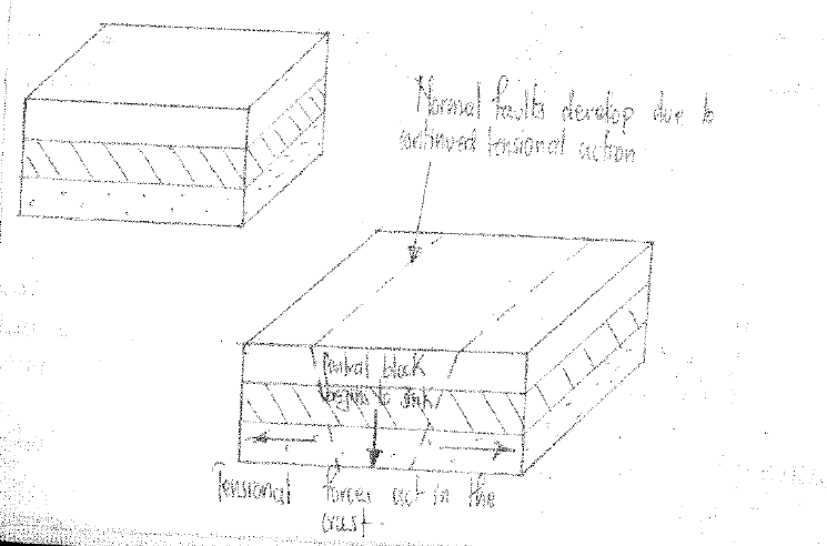
3.5 INFLUENCE OF FAULTING ON LANDFORM FORMATION IN EAST AFRICA
Faulting is a form of earth movements which involves the breaking or fracturing of the crustal
rocks and the relative displacement of rocks of the crust on either side of the fracture.
Faulting is as a result of radio-activity, geo-chemical and geo-physical reactions in the mantle /
interior of the earth.
These reactions generate a lot of heat and pressure which melts the rocks to become molten and
result into the development of convective currents which move vertically, horizontally and in a
circular motion and lead to the development of various forces like tension, compression and
vertical forces of uplifts and subsidence.
Faulting through the above forces results into the formation of a number of landforms e.g:-
RIFT VALLEY
A lift valley is an elongated trough bordered by in facing escarpments along more or less parallel
faults.
The origin of the rift valley is still a matter of debate therefore many theories have been
advanced to explain the formation of a rift valley and these theories are related to radioactive
and geochemical reactions within the interior of the crust.
(i) Tensional theory
It was advanced by J.W Gregory. He suggested that radioactive and convective currents
produced tensional forces within the earth’s crust.
The tensional forces pulled apart the crust in opposite directions from the central point
creating normal fault lines. These divided the crust into three blocks. This was followed
by displacement of the blocks.
The central block became unstable and sunk under its own weight where as the side
blocks remained stable. The sunk unstable central block formed a rift valley.
Erosion, mass wasting and weathering modified the sides of the slopes. The Eastern
branch of the East African rift valley is believed to have been formed in this manner.

- pg. 30
(ii) Compressional theory
This was advanced by E.J Wayland. He believes that convergent convective currents
pushed the crust in the same direction as they created the compressional forces.
The action of pushing by compressional forces created reverse fault lines within the crust,
dividing the crust into three blocks.
The continued pushing by the compressional forces made the side blocks become
unstable and the central block became stable.
The unstable side blocks overrode / upthrusted / uplifted over the central stable block
which became a rift valley.

- pg. 31
The Albertine section of the East African rift valley is believed to have been formed in this
way.
(iii) Differential uplift theory
This was advanced by Trudy and Dixy basing on the Nairobi section of the East African
rift valley.
This theory assumes that multiple fault lines developed within the crust, dividing the
crust into a series of blocks. This was followed by the general uplifting of the faulted
region.
The side blocks were uplifted much faster and higher than the central block which
experienced a slow uplift and therefore remained at a low level hence forming a rift valley
e.g. the Nairobi section of a rift valley.

- pg. 32
(iv) Relative sinking theory
This theory assumes that multiple fault lines developed in the crust and this was followed
by a general sinking of the region where the central block sunk faster and lower than the
side blocks which remained up. The sunk region became a rift valley.
(2) BLOCK MOUNTAINS / HORST
A block mountain is an upland or raised large block of land surrounded by fault scarps. It
generally stands above the surrounding land with sharply defined edges e.g. mountain
Rwenzori, Uruhuru, Usambara, Mahenge, Ufipa plateau, Pare, Iramba plateau in Tanzania
and Nyiru ,Ndoto and Mathew ranges in the rift valley near Lake Turkana.
FORMATION PROCESS OF THE HORST
A block mountain is formed by a process of faulting through several theories.
Formation of a block mountain by compressional forces.
Advocates of this theory believe that the compressional forces pushed the crustal block
on either sides resulting into stressing and hence development of reverse faultiness. This
divided the crust into three blocks.
As the action of compressional forces continued, the unstable middle block overrode/
upthrusted the adjacent stable side blocks.

- pg. 33
The risen unstable middle block formed a block mountain / horst as shown below.
Tensional forces acted on the crustal block by pulling in opposite directions away from each
other. This led to the development of normal fault lines in the crust which divided it into three
blocks.
The continued action of tension forces led to the subsidence unstable side blocks while the
middle block remained stable and high above the side blocks. This became a horst or block
mountain.

- pg. 34
Formation of a block mountain by differential uplift theory
This is due to multiple faulting which formed a series of crustal blocks of varying sizes and
densities.
When the forces of uplift acted on the crustal blocks with varying strength, uplift forces were
strongest on the central block.
The central blocks were forced to rise faster and higher than the side / blocks to form peaks of a
horst / block mountain.
The side blocks didn’t rise high enough but formed the sides of the horst as shown below.
(Diagram)
FORMATION OF A HORST BY RELATIVE SINKING THEORY
Multiple fault lines developed within the crust dividing the crust into a series of blocks. This was
followed by the general sinking of the faulted region where the side blocks sunk much faster and
lower than the central blocks which remained high above the sunk side blocks. These became
the horst / block mountain.

- pg. 35
(Diagram)
ESCARPMENT / FAULT SCARP
An escarpment is a steep side of a rift valley or block mountain which forms an abrupt change in
the gradient / height as one goes down a rift valley / block mountain. It may be as high as 50m
from the rift valley floor e.g. Butiaba, Kicwamba, Kyambura, Bunyaruguru in Western Uganda,
Manyara and Chungwa in Tanzania, Elego and Mau in Kenya.
It is formed as a result of faulting when there is development of a single fault line in the crust.
One of the blocks on one side of the fault line sinks down along the line of the fault while the
adjacent block is either uplifted or remains in its original position, forming a suddenly steep
sharp break in the gradient of the slope called an escarpment.
N.B: When an escarpment is worn down by denudational forces, it becomes a fault scarp which
is a gentle slope on either side of the rift valley.
(Diagram)

- pg. 36
TILT BLOCKS
There are landforms in form of ridges and depressions formed by faulting and tilting of land
along fault scarps followed by displacements. Examples of tilt scarps are along the Rift valley
where they form deep bedding planes and western Kenya in Abadare region.
(Diagram)
FAULT GUIDED VALLEY
This is a valley as the name suggests that develops in a fault line and follows the direction of a
fault line. It is steep sided and has a flat floor. As faulting takes place, the rocks crossed by the
fault line are crushed and shuttered. The shuttered rocks are then eroded there by resulting into
the creating of along valley along which a river may flow e.g. Aswa valley in northern Uganda,
Kerio river valley, Ewaso-Ngilo river valley in Kenya, R. Ruhuhu valley in Tanzania.
(Diagram)
(i) Before denudation (ii) After denudation
- pg. 37
GRABEN
Account for the formation of a Graben.
Approach:
- Define a graben.
- Identify the formation process i.e. faulting.
- Define faulting; describe the origin and causes of faulting.
- Mention the fact that a Graben forms in series / stages i.e. beginning with a formation of a rift
valley.
- Then describe the theories responsible for the formation of a rift valley.
- At the end of each theory indicate secondary faulting acting on the floor of a rift valley
leading to the formation of a Graben.
FORMATION OF GRABEN
A Graben is an elongated deep steep sided depression on the floor of the rift valley.
It is formed as a result of secondary faulting taking place on the rift valley floor which leads to
secondary sinking of part of the rift valley floor to form a depression or hollow called a graben.
Examples of grabens include; Albert graben, Tanganyika Graben, Turkana graben e.t.c.
Formation of Grabens by compression
(Diagram)

- pg. 38
Formation of Grabens by tension
(Diagram)
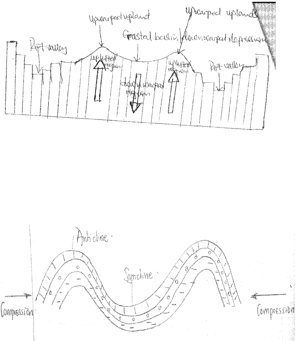
3.6 WARPING
Is a form of earth movement / diastrophism that involves sagging, subsidence / sinking of land
masses in one region as other regions are getting uplifted. Warping in East Africa led to the
formation of up warped highlands.
This involved land e.g. on the Eastern side of rift valley side of the western arm of the East
African rift valley, getting uplifted/up warped after the formation of the rift valley. This created
up warped uplands e.g. in Buhwezu, Hoima, Masindi e.t.c
. Warping also led to the formation of down warped / crustal depression or basins. These refer
to extensive, shallow, irregular and saucer depressions onto the earth’s surface. They were
formed as a result of down warping
. After the formation of the great East African rift valley, the Eastern side of the western arm of
the rift valley and the western side of the Eastern Branch of the rift valley were uplifted/up
warped. While central East Africa was down warped / sagged / sunk to create a down warped
/crustal basin.
- pg. 39
(Diagram)
3.7 FOLDING
It leads to the formation of Fold Mountains characterized by anticlines and synclines. This
happens when compressional forces within the crust act on young rocks which get folded
instead of fracturing.
Outstanding folded mountains with synclines and anticlines are in north western Tanzania,
south western Uganda and in Masindi.
(Diagram)

- pg. 40
3.8 EFFECTS OF EARTH MOVEMENTS ON THE DRAINAGE OF EAST AFRICA
- Faulting led to the formation of graben lakes e.g. L. Turkana, L. Albert, L. Tanganyika e.t.c.
- It led to the formation of waterfalls e.g. Murchison falls and Kalambo waterfalls on the south
western boarder of Zambia and Tanzania.
- Faulting led to the formation of fault guided rivers e.g. R. Aswa and Kerio.
- Warping led to the formation of down warped lakes e.g. L. Kyoga, L. Victoria,
L. Wamala, L. Kijanebarora
, L. Mburo.
- Upwarping led to river reversal e.g. R. Kafu, R. Kagera, R. Katonga.
- Faulting which created waterfalls led to swift flow of rivers over the waterfalls or
escarpments e.g. R. Nile as it enters L. Albert.
- Faulting led to the formation of Block Mountains which are glaciated and are sources of
rivers e.g. Mountain Rwenzori with rivers like Mubuku, Bujuku, Nyamwamba, Rwimi which
originate from the melting waters of glaciers.
- River reversal due to up warping created several swamps in central and western Uganda.
- Down warping which created crustal basins led to the development of centripetal drainage
patterns.
- Faulting which led to the formation of Rwenzori, Block Mountains which has several rivers
flowing out of it, led to the development of radial drainage patterns.
- Faulting through the development of fault guided valleys led to the development of trellis
drainage patterns where tributaries join main rivers at right angles.
Qns:
(a) Examine the influence of earth movements land form development in East Africa.
(b) Explain the influence of earth movements on the drainage of East Africa.
(c) Account for the formation of a Graben.
4.0 VULCANICITY
Vulcanicity is a geomorphic process which involves the movement of molten rocks (magma,
gases and solid particles) from the earth’s mantle to the earth’s surface to lead to the formation
of extrusive features / land forms or magma may be intruded / injected to lead to the formation
of intrusive volcanic features.
Vulcanicity is a result of geochemical, geophysical reactions and radioactivity within the mantle
which lead to the melting of rocks into a molten form called magma which is highly mobile. The
magma is pushed with great pressure from the mantle through faults and injected into or onto
the earth’s crust to lead to vulcanicity.

- pg. 41
4.1 INTRUSIVE VULCANICITY
This involves the intrusion/ injection of magma within the interior of the earth to lead to the
formation of various intrusive volcanic features which when exposed to the surface by
denudation, they lead to the formation of landforms / relief features which include;
DYKES
A dyke is a cylindrical mass of rock formed within the earth’s crust. They are often perpendicular
within the crust.
Dykes are formed as a result of very acidic magma being intruded within vertical fissures /
events to form walls of solidified magma. It may be vertical / steeply inclined.
When dykes are exposed onto the earth’s surfaces by weathering and erosion. They form
elongated ridges / hills if harder than the surrounding rocks e.g. Isingiro ridges / hills, ridges in
Busia and Kisumu and Rungwa.
Dykes may form linear trenches if softer than the surrounding rocks e.g. around L. Turkana.
Diagram:
Before denudation
SILL
Is a narrow sheet of solidified magma which is intruded horizontally within the bedding plane.
It is formed when basic magma is injected between bedding planes and cools.
It forms relief landforms known as flat topped hills, cliffs or escarpments e.g. can be seen along
Pakwach, Arua road (Karuma) falls, Mubende hills, Kakinzi in Luwero e.t.c when exposed by
denudation.

- pg. 42
Diagram:
Before exposure
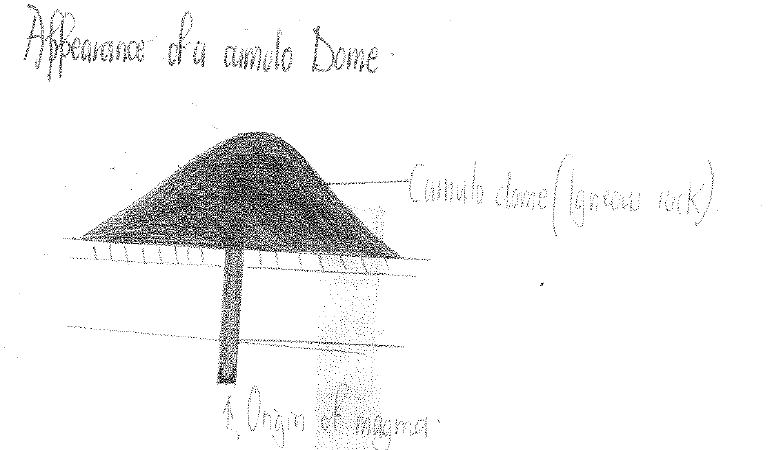
LACOLITH
Is a dome shaped mass of solidified magma with a flat base within the earth’s crust.
It is formed when viscous / acidic magma fails to spread far and therefore accumulates in a large
mass and then solidifies very fast. It forms near the earth’s surface.
On exposure, laccolith forms uplands e.g. Voi, Kitui in Southern Kenya.
Appearance of lacolith
LAPOLITH
This is a very large saucer shaped volcanic intrusion / mass of rocks within the earth’s crust.
It is formed when viscous magma forces its way into the bedding planes, thereby quickly
solidifying.

- pg. 43
Their shape is as a result of the mass of rock which overlies them which depresses the
underlying rocks causing sagging .When exposed to the earth’s surface, a shallow wider saurcer
shaped depression called an Arena is formed e.g. Rubanda Arena in Kabale.
BATHOLITH
Is a dome shaped mass of solid magma formed at a great depth within the interior of the earth.
They seem to continue up to the earth’s core. And they are composed of granitic materials whose
base is not identified. They are the largest intrusive volcanic features.
It is formed when acidic magma is intruded at great depth within the earth’s crust and solidifies
very slowly.
When exposed to the surface, it may form a rocky highland or upland covering hundreds of
square kilometers known as an inselberg e.g. Labwor and Parabong hills in Eastern Acholi,
Kikandwa hills in Mubende, between Mwanza and Iringa, Kacumbala in Bukedea, Nyero rocks in
Kumi.
Where batholith are exposed and are weaker than the surrounding rocks, they form larger
saucer shaped depressions known as Arenas.

- pg. 44
4.2 EXTRUSIVE VOLCANIC FEATURES
This involves the ejection / extrusion of larva onto the earth’s surface to lead to the formation of
various extrusive volcanic features which include;
VOLCANOES / VOLCANIC CONE
A volcano / volcanic mountain is a conical shaped steep sided highland ranging from a few to
thousands of metres in height containing circular depressions on their tops / slopes known as
craters.
It is formed when acidic magma rises through the main vent and on reaching the earth’s surface,
it piles / accumulates around the vent, solidifies forming a volcanic cone / mountain e.g.
mountain Kilimanjaro, Elgon, Mufumbira, Nepak e.t.c.
Diagram:
TYPES OF VOLCANOES
Composite volcanoes. This is a volcano which is conical in shape ranging from hundreds to
thousands of metres high. It may be surrounded by several volcanic cones with different layers
of pyroclasts. It is formed when an explosive eruption takes place in the previous volcanic
mountain and forms a small composite cone on top. It is called a “Volcano within a volcano”. E.g.
Virunga Mountain ranges East of Zaire, Muhavura mountain ranges in south western Uganda.
Diagram:

- pg. 45
ASH AND CINDER CONES
These are conical hills formed as a result of volcanicity and are composed of alternating layers of
pyroclasts (cinder) and volcanic ash which reaches the earth’s surface due to excessive pressure
and gas from below.
They are formed due to successive violent eruptions of pyroclasts and ash from the vent. Lava is
blown to great heights into the air in a liquid form and returns to the ground as semi-solid
cooled pieces called cinders and ash if very small. They often contain craters on their summits
e.g. include Luiru, Likaiyu, Teleki in Kenya, Nabuyatoni, Abili-Agituku in north eastern Uganda
and between mountain Muhavura and L. Mutanda.

- pg. 46
Diagram:
`LAVA CONES
These are cones mainly composed of lava and have gentle slopes and have a wide base. They are
formed as a result of lava being ejected onto the earth’s surface, pilling around the vent, cooling
and solidifying forming a gently sloping cone.

- pg. 47
BASALT DOMES / SHIELD VOLCANOES
Is a landscape which is dome shaped with a very large shallow depression on gently sloping
landscape
. It is formed as a result of basic magma reaching the earth’s surface through numerous, fissures
and may flow for long distances before solidifying.
Their formation involves ejection of gases on the earth’s surface and are often explosive egs.
exist in south western Uganda in groups of Nyamulangira where there are about 8 basalt domes,
the Virunga and Mufumbira ranges in Zaire and northern Rwanda.

- pg. 48
LAVA PLATEAU
Is a raised steep sided flat land. They are formed when basic lava reaches the earth’s surface
through numerous vents, flows for longer distances as it piles up to form a large raised flat land
called a lava plateau e.g. Kisoro highlands, Voi plateau and Laikipia plains in Kenya.
EXPLOSION CRATERS
This is a shallow steep sided depression-surrounded by a low rim of pyroclasts.
It is formed when an explosion of gases and some pyroclasts takes place on a flat landscape
without forming a volcanic mountain and the explosion is less violent, instead, it forms a shallow
depression on a slightly raised ground surrounded by a rim of pyroclasts. Examples include;
- Lake Katwe crater,
- Nyamunuka
- Munyanyange in Queen Elizabeth National Park
- Nyabihoko, Rutoto in Rubirizi, Kigere and Nyabikere in Fortportal, Garana and Ndoboto in
Tanzania.

- pg. 49
MOUNTAIN CRATERS
Are circular depressions found on the top / side of a volcano. It is bowel / funnel shaped with in
facing steep slopes.
It is formed as a result of successive violent eruptions which blow off the top of a volcano leaving
behind a circular depression called a crater e.g. Menengai, Suswa, Kilimanjaro crater, Rutunguru,
Shambole e.t.c.
A CALDERA
Is a large shallow circular depression at the top of a volcanic cone. It may be occupied by small
volcanic cones called tholoids.
Two theories are advanced to explain the formation of calderas namely;
A caldera can be formed by a very violent eruption which blows off the top of a volcanic cone
leaving behind a large circular depression called an explosive caldera.
The best examples of calderas include Longnot caldera in the eastern arm of the Rift valley in
Kenya.
A caldera may also be formed as a result of cauldron subsidence of rocks on top of a volcanic
mountain.
The rock subsidence into the earth’s crust due to reduced pressure from the earth’s mantle.
In case a volcano sinks, minor volcanic eruptions continue and form volcanic cones called
Tholoids at the base of a caldera e.g. of such subsidence calderas include; Manengai, Ngorongoro
in Tanzania and Akaigodi caldera in Nyakasura.

- pg. 50
Diagram:
During explosion
A CUMULO DOME
Is a dome shaped feature/solidified mass of magma which ranges from tens to hundreds of
metres forming hills of igneous rocks in a region.
They result from volcanic eruptions which fail to reach the earth’s surface and magma solidifies
within the earth’s crust.
Later on, secondary eruptions may push the solidified steep sided convex domes known as
cumulo domes.
Cumulo domes may also be formed by viscous magma which solidifies instantly on the earth’s
surface failing to form volcanic mountains as illustrated below. Examples include Mbea rock in
Tanzania, Nakasongola rock, Ntumbi cumulo dome and in the Tsavo national park.
- pg. 51
VOLCANIC PLUG
Is a cylindrical dome of igneous rock which stands out prominently vertically on the earth’s
surface.
It is formed when volcanic eruption occurs and the acidic magma gets out of the earth’s crust
when already solid and cylindrical.
The plug may later be weathered down and eroded or may remain in place for a long while e.g.
Tororo rock.
VOLCANIC NECK
This is a cylindrical mass of hard rock standing out vertically on the earth’s surface after
exposure by erosion of rocks surrounding it.
Volcanic necks are farmer volcanic vents which failed to reach the earth’s surface during
volcanicity but because of erosion, the vents were exposed onto the earth’s surface e.g. Tororo.

- pg. 52
4.3 OTHER FEATURES OF VOLVANICITY
1. HOT SPRINGS
These are streams of super-heated warm, water originating from the earth’s crust and reach
the earth’s surface frequently in a fountain nature.
They are formed when water from rain, snow or plutonic sources seeps through rock cracks
and collects in underground coverns/sumps
During its passage, the water may come into contact with the hot rocks and later may re-
emerge as a spring of warm or hot water after being pushed upwards by underground
pressure onto the earth’s surface in a fountain nature.
At times, the water may carry chemicals in solution which are often deposited in thick layers
around parts of rim of the spring exit.
Examples of hot springs include:-
- Sempaya hot springs in Bundibugyo
- Kitagata hot spring in Bushenyi
- Kisizi hot spring in Rukungiri
- Kibiro hot spring in Hoima
- Njorwa, Majiya moto and L. Hannington
- Aboni and Maji moto in Tanzania
Diagram:
- pg. 53
GEYSERS
These are jets of boiling water intermittently reaching the earth’s surface due to its being pushed
from the underground by great pressure. They are formed as a result of water from the rain,
plutonic sources e.t.c. collecting in underground rock-sumps that boarders very hot rocks and
traps steam behind it.
As the steam increases, its pressure builds up to a point where it pushes water out with violence
Examples are in Lake Hannington in Kenya, Longonot crater, between Elementaita and Naivasha,
Menengai in Kenya and in Tanzania at Aboni and Kalimanjaro.
Qn.1:
To what extent are highlands in East Africa a result of volcanicity?
Approach:
- Define highlands
- Make an evaluation i.e. state an extent.
- Show the role of volcanicity in the formation of highlands but first define volcanicity and
show its origin and causes.
- Highlands resulting from volcanicity include;
- Volcanoes
- Composite volcanoes
- Ash and 8 cinder and cones
- Lava cones
- Basalt domes

- pg. 54
- Volcanic plugs
- Lava plateaus
- Cumulo domes
Role of other processes i.e.
- Folding led to formation of fold mountains
- Faulting led to formation of block mountains
- Denudation led to the formation of inselbergs
- Conclusion
Qn.2:
Account for the formation of a caldera
- Define a caldera.
- Identify a caldera as a volcanic feature formed by volcanicity.
- Define volcanicity and define its origin and causes.
- Describe the formation of a caldera using the two theories i.e. cauldron subsidence and
volcanic explosion.
MASS WASTING
Mass wasting is the down ward/downhill movement of rock materials along a given slope under
the influence of gravity
Definition; It is the sliding off, the creeping , the falling off or the down ward movement of rocks,
weathered materials, rock fragments, saturated soils (mud) down the hill due to the influence of
gravity
Gravity can only play its role when the materials overcome their initial resistance to the
movement. The major factor that helps to overcome this resistance is water. Water saturated
mass moves more easily because of the increase of the weight in the mass and also reduces the
cohesive force of the particles making them to be loose and hence easily moving downwards
Unlike erosion, mass wasting does not require a transporting agent such as running water but
even dry rocks can move freely on steep slopes. Although mass wasting is denudation process
the major influence is gravity
TYPES OF MASS WASTING
There are two types of mass wasting i.e.
1. Rapid movements/ landslides which occur on steep slopes due to the existence of the steep
gradients as a result of gravity.
2. Slow movements which occur on the gently sloping regions due to the gently sloping
gradients.

- pg. 55
RAPID MOVEMENTS/ LANDSLIDES
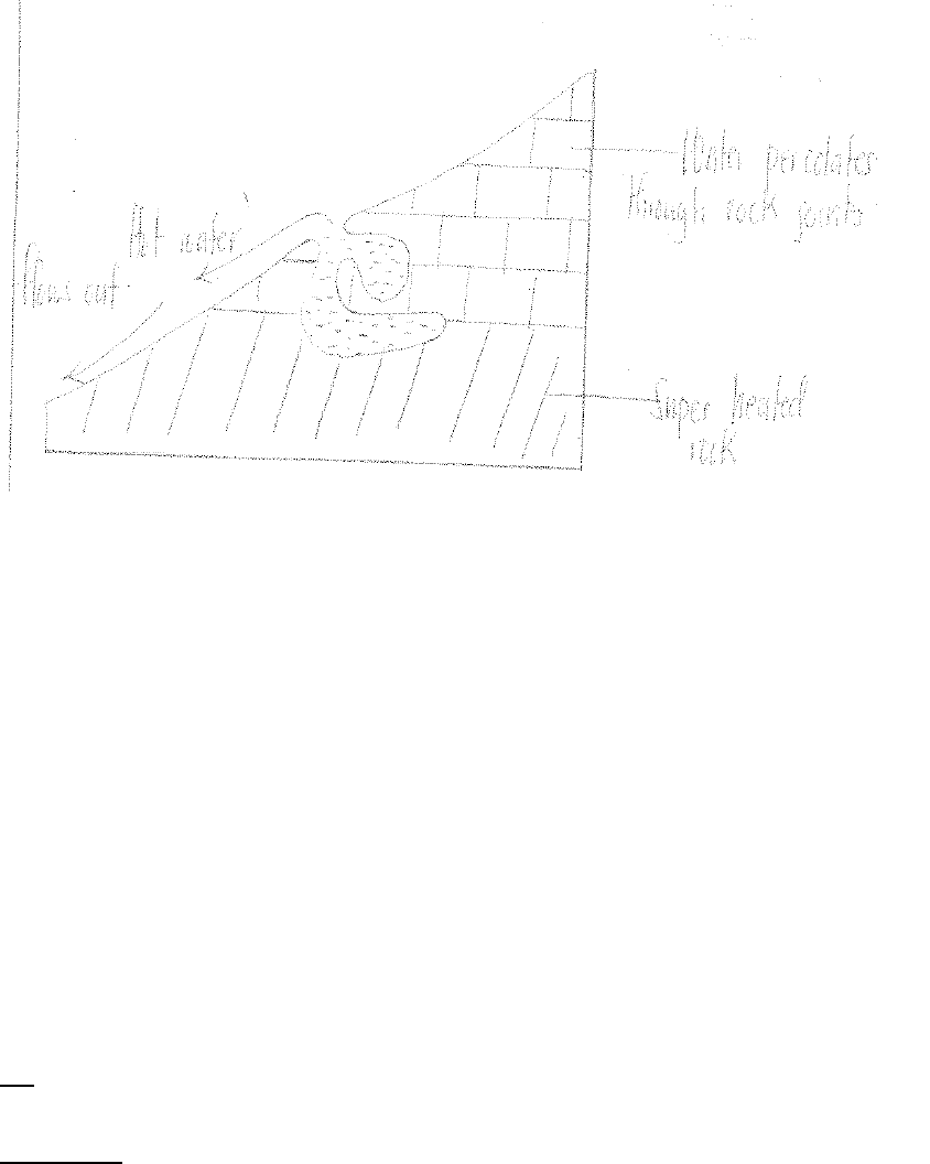
A landslide is the type of mass wasting that involves a rapid, abrupt, and sudden downhill
movement of loose rocks and other weathered materials on a moderately steeply sloping area /
region, fairly steeply sloping region and a very steeply sloping region under the influence of
gravity.
The process may be aided by running water acting as lubricant landslides are common on road
cuttings, valley slides e.t.c.
It is common in areas of Bundibugyo, on slopes of mountain Rwenzori, Bududa on slopes of
mountain Elgon, Kilimanjaro and Kigezi highlands.
Types of landslides
1. Mud flow
This refers to relatively the rapid movement of semi-liquid, saturated soils, mud or
unconsolidated gravel and weathered materials on moderately steeply sloping regions under
the influence of gravity
It is common in areas of heavy rainfall where materials become sticky and flow off especially
where porous/ well jointed and permeable rocks easily get saturated and slide off over the
impermeable rocks it is common in high land areas such as Bugisu area, Kigezi high lands,
Kenya highland, Kilimanjaro e.t.c.
Diagram.
Talus creep
This refers to the movement of waste materials of all sizes of moderate rocks under the
influence of gravity
The materials move moderately fast and it is common where there is freeze thaw action. It is
caused by heavy vibration of moving vehicles or earthquakes which loosen the rock and
eventually they move down slope under the influence of gravity e.g. on mountain Rwenzori
Talus creep
Diagram

- pg. 56
Rock slump/ slumping
It involves very fast movement of large masses of rock debris over a very steep slope under the
influence of gravity. It is common in massive poorly jointed rocks where permeable rocks e.g.
limestone rocks (soils) are overlying the impermeable rocks like clay.
When it rains, permeable rocks absorb water and their weight increases. The cohesive force
reduces hence easily sliding off from the slippery impermeable rock. This leaves behind fresh
scars that are steep due to further denudation processes
Diagram
Rock slides
This involves the detachment of large quantities of rock or large masses of rocks over steep
slopes e.g. cliffs. The rocks at a very high speed under the influence of gravity. This occurs on
steep slopes, escarpments, road cuttings accelerated by heavy rains
Rocks slides are common in areas like Bundibugyo, Kigezi highlands and Bugisu highlands
Diagram

- pg. 57
Rock fall.
It is the fastest movement among the others which involves the abrupt/ sudden fall of
individual rock particles/ boulders over a very steep vertical slope under the influence of
gravity
It occurs in localized areas and they leave behind steep like features. It also occurs in well
jointed rocks e.g. mountain Elgon and Rwenzori slopes. It is also common where rocks are well
jointed and loosened by freeze thaw action
Diagram
SLOW MOVEMENTS
This involves the movement of large quantities of loose materials over very gentle, moderately
gently sloping areas under the influence of gravity. There are mainly 2 processes of slow
movements and these are; soil creep and solifluction.
Soil creep
This involves the downhill slow movement of soils and fine materials on a very gentle slope
under the influence of gravity.
Soil creep produces small steep like features along the slope called terracettes.

- pg. 58
It is influenced by gentle slopes, scanty vegetation and vibrations from moving vehicles
The vegetation appears in a bent structure along the gently sloping areas.
Diagram
Solifluction
This involves the movement of saturated soils, gravel and weathered rocks (partially weathered
rocks) down the gentle slope under the influence of gravity.
The materials move slowly in an intermediate form over the moderate gently sloping areas.The
process is limited to mountainous areas where freeze thaw action takes place. Thawing causes
the saturated soil layers to creep, slide off over the mass of underlying frozen ground e.g.
Rwenzori and Kenyan high lands and this also results into the formation of terracettes
Diagram
SUMMARY TABLE ON MASS WASTING.
Type
Material
Slope
Type of
movement
soil creep
Soil and fine materials
Very gentle
Slow movement

- pg. 59
solifluction
Saturated soil gravel and
weathered rock
moderate
Slow movement
Tulus
creep
Angular waste rock of all
sizes
moderate
Fast movement
Mud flow
Semi-liquid mud with
gravel and boulder
Moderate to steep
Fast movement
Slump
Rock slide
Large masses of rocks and
debris
Over steepened e.g.
scarps, cliffs and roads
cutting
Fast movement
Rock fall
Individual rocks and
boulders
Very steep to vertical
Fast movement
FACTORS INFLUENCING MASS WASTING IN EAST AFRICA
1. Relief
The steeper the slope/ gradient, the faster the rate of movement and vice versa. Steep slopes
e.g. escarpments, river banks, cliffs and steeply mountainous areas accelerate the fast and rapid
downhill movement of loose rock masses, fragments, soil particles due to the rock slides, slopes
of mountain Rwenzori e.t.c.
However, the gentle slopes accelerate the occurrence of slow movements. This is usually on
fairly gentle slopes through processes like soil creep, solifluction where the gently sloping
gradient limits the rate of mass movements.
2. Nature of parent rock
(i).Rock resistance. Some rocks are weak and soft while others are hard and resistant. Soft rocks
like limestone easily to absorb water which increases their weight to accelerate mass wasting
i.e. they move faster than the hard rocks causing mud flows, soil and creeps
(ii). Permeability of the rock. Permeable rocks like limestone and other overlying soft weathered
rocks allow water to percolate through them and this makes influence of gravity, they limit the
occurrence of mass wasting through rock slides, rock slumping. Rock falls in areas of Kigezi
e.t.c.
- pg. 60
(iii). Rock jointedness. Jointed rocks also accelerate mass movements as they allow water to
perforate through the joints resulting into increased rock weight and lubrication of the rock
mass making it easy for the rock to move down the hill due to the influence of gravity. This is
through talus creep, rock fall, and rock slide e.t.c.
(iv). Mineralogical composition of the rock. Rocks that contain calcium e.g. limestone rock are
soft and easily absorb water therefore making them saturated hence resulting into increased
rock weight and lubrication of the rock mass making it easy for the rock to move down hill due
to the influence of gravity.
On the other hand, rocks that contain iron are hard and don’t absorb water therefore facilitating
slow movements like soil creep, solifluction.
3. Climate
The different climatic types influence mass wasting in the following way;
Equatorial climate characterized by heavy amounts of rainfall and hot temperatures. The
heavy rainfall makes the rock soft increasing their weight and friction against the different
rock joints. This enhances mass wasting movements inform of mud flows, rock slides, rock
fall common in mountain elgon highlands , kigezi high lands e.t.c.
Savannah/ tropical climate. Chacterised by wet and dry seasons where during the wet season,
the different rock particles are saturated accelerating mass wasting movements such as mud
flows, rock slide in areas of kilimanjaro.
Montane climate. Characterized by heavy rainfall on the windward side of mountains such as
mountain kilimanjaro, mountain elgon, mountain rwenzori where the rainfall dissolves down
the rock accelerating mass wasting movements due to the influence of gravity inform of rock fall,
rock slide e.t.c.
Nb;
the influence of temperature in diff climatic regions influences mass wasting secondly as
discussed below.
Rocks are weathered down due to the influence of hot temperature that accelerate contractions
and expansion (physical weathering).
This causes rock disintegrations causing downhill movement of rocks due to influence of gravity
e.g. Through rock fall, rock slide.
- pg. 61
On the other hand on glaciated mountains temperature changes weaken the rock through frost
shuttering and thus they are easily detached off from the underlying rocks due to influence of
gravity, this explains the existence of solifluction, talus creep in mountainous areas of east africa.
Vegetation absence of forest vegetation increases the movement of soil particles, rock
fragments down the hill due to the influence of gravity.
However, the presence of vegetation will limit the movement of soil particles down the hill/
slope.
The roots of the plants hold particles hence reducing the chances of rock movements and where
the forest have been cleared mass wasting is very common through rock falls, talus creep. This
is because the rocks are exposed hence reducing their resistance/ cohesiveness e.g. The slopes
of mountain rwenzori.
Occurrence of earth quakes
These are vibrations that are set up by the forces of the earth movements. Vibrations from earth
quakes widen the rock joints and loosen the rocks hence leading to the downhill movement
under the influence of gravity. This explains the existence of rock falls, rock slumps in areas of
bundibugyo.
Volcanism
Volcanic activities that are associated with violent eruptions emitting gaseous materials,
magma/ larva hence flowing along steep slopes at a high speed due to the influence of gravity.
This explains the existence of mud flows along the slopes of mountain elgon.
Movement of heavy objects
The vibration of moving heavy vehicles, trains due to the influence of gravity trigger the
downhill movement of loose rock materials inform of soil creep, rock slides e.t.c. These are
common on road cuttings especially in mountainous areas of kigezi and kapchorwa.
Man’s activities
Mining and quarrying especially where explosives are used in blasting the rocks. The rocks are
weakened and easily move in form of rock falls, rock slumps e.t.c. Explosives also generate
vibrations leading to soil creep e.g. Kilembe stone quarrying in wakiso e.t.c.
Digging down slope weakens/ loosens the rocks that are finally set into motion by gravity this
explains the existence of rock slides, slumping, rock creep e.t.c
Deforestation. As forest are cut down along steep slopes, the soil and rocks become loose and
this explains the existence of mud flows, rock slides, in areas of bundibugyo.
Questions
1 To what extent are physical factors responsible for the occurrence of landslides in East Africa?
2 Account for the occurrence of landslides in East Africa.

- pg. 62
3 To what extent has relief contributed to the rate of landsides on any one mountain in East
Africa
EFFECTS OF MASS WASTING
Mass wasting has resulted into both positive and negative effects
Negative effects
1- There is destruction of communication lines e.g. roads, railways, telephone masts. Ridges e.g.
kisoro-Kitgum road in 1998 it was filled with mud as a result of mud flows, Bundibugyo and
road in 1989 was destroyed by mass wasting
2- Landslides lead to the destruction of property and life e.g. in 1966 in Bundibugyo 1 person was
killed, Bududa in 2010 over 300 people were killed in mud flows and a lot of property was
destroyed.
3- It has resulted into destruction of agriculture and as the fertile hill slope soil are moved down
slope leaving less productive in terms of agriculture
4- Landslides uproot the trees contributing to the destruction of forests e.g. the slopes of mountain
Elgon
5- Materials deposited in low lying areas pollute the water sources causing to the local people e.g.
cholera
6- Materials deposited on low lying areas displace water channels resulting into floods in the
nearby areas of Bugisu region.
Positive effects
1- Mass wasting creates new land forms e.g. the terracettes in Bushenyi from soil creep like in
shema district in south western Uganda
2- The removal rock masses may settle in the valleys and broke streams resulting into formation
of lakes e.g. in 1955, Tukya landslides in Kenya blocked a river valley and formed a temporary
lake called Mbala that lasted for only 8 years
3- The materials deposited in low lying areas are usually fertile and suitable for agriculture hence
creating/ improving agriculture outputs.
4- Mass wasting exposes the mineral deposits to the surface and thus ensuring mining process e.g.
Wanale ridge on mountain Elgon.
5- The features created by mass wasting like terracettes spurs attract tourists hence enhancing
the tourism sector
6- Mass wasting helps in the research and geography studies for student e.g. the Bududa land
slides
Measures taken to control mass wasting
1. Afforest ration and re-a forestation should be carried out on the steep slopes to create a
forest cover through tree planting and re-planting in order to reduce the effect of mass wasting
- pg. 63
such that the tree roots behind together and making them firm against mass movements e.g. on
mountain Elgon forest reserve and Kigezi forest the depressions within the hanging slopes left
after mining and quarrying should be filled with waste materials such as soils and rocks. This
gives a basement to the hanging steeps from washed away.
2. Mass sensitization should be carried outi.e. people should be taught about the dangers of
deforestation and settling on steep slopes. This will reduce on the rate of people who destroy
the vegetation cover and this can be done through seminars, newspapers, televisions e.t.c.
3. Law enforcement should also be applied , sometimes laws protecting the environment
exist and such laws should be strictly enforced to discourage destruction of the environment
4. The government should also set up resettlement schemes to reduce on the number of
people living in area affected by landslides. Resettlement reduces the risk of people
5. There should be controlled grazing and stocking of animals which cause destruction on
the vegetation cover hence reducing the chances of mass wasting.
6. Construction of gabions on the slopes created by road cutting and cliffs to reduce surface
run off (mud flows and other processes of mass wasting).
Questions
1Examine the causes of landslides and measures taken to control mass wasting.
2Account for the occurrence of landslides in East Africa
3To what extent are physical factors responsible for the occurrence of landslides in East Africa?
4To what extent has relief contributed to the rate of landslides on highland areas of East Africa?
- pg. 64
6.0 DENUDATION
This is the external or exogenic process which involves lowering of the level of land by wearing
it away or raising the level of land by deposition.
6.1 WEATHERING IN EAST AFRICA.
This refers to the chemical decomposition and physical disintegration of rocks into small
particles near or at the earth’s surface in situ.
There are two major types of weathering i.e. chemical and physical weathering.
6.2 PHYSICAL / MECHANICAL WEATHERING
This is the breakdown of rocks into increasingly small fragments without changes in chemical
composition of rocks in situ. It occurs due to temperature fluctuations heating and cooling, frost
action and due to the influence of plants and animals (biotic factors)
PHYSICAL WEATHERING PROCESSES
Block disintegration
This is a process where rocks are broken into small blocks known as block disintegrations. This
process is common in semi-arid and arid areas, dry cloud less regions with a very high marked
diurnal range of temperature due to direct heating during day and rapid cooling at night. The
rocks successively expand and contract and soften to enlarge joints in rock masses which
ultimately break into small blocks called block disintegrations.
- pg. 65
This process is very common in well jointed rocks and leads to the breakdown of rocks into large
rectangular shaped blocks e.g. exposed plutonic rocks e.g. granite.
It is also common in areas with heterogeneous rocks. This type of rock disintegration results into
the formation of landforms like granitic tors and inselbergs.
It’s common in Kumi, Kachumbala, Mubende tors, Bismark rock in Mwanza Tanzania.
Exfoliation
In some rocks, the surface can be so intensively heated that it expands more rapidly than the
underlying rock layers. Suddenly, cooling may occur during showers such that the upper surface
layers peel off from the cooler interior. This process is called exfoliation and it leaves new rock
layers exposed to the surface. It results into the formation of features known as exfoliation
domes which are common in Soroti, Kumi, Lira, Kitgum, and Serengeti with exposed granites.
Freeze and Thaw (Frost Action)
This is caused by water being converted into ice where temperatures fall below freezing point
on higher mountains of East Africa e.g. Kenya, Rwenzori. When water fills the cracks within the
rock at night and such a volume increases at a rate of 10% as it freezes, this increasing volume,
exerts pressure on the sides of the cracks and these widened cracks could deepen, causing the
rock to weather.
Pressure release (Offloading)
This occurs when the rock masses have been exposed by the removal of the overlying rock
debris by denudation. The gradual release of pressure (unloading) causes the rocks especially
granites to expand and joints and cracks develop within the rocks. Surface layers begin to peel
off like in exfoliation.
Alternatively, rain water begins to penetrate into these joints and cracks and chemical
weathering proceeds. It’s common on emerging granites of Panyok in Apac, between Mwanza
and Iringa, Serengeti and Rukwa region.
Salt crystal growth (Crystallization)
This occurs when some rocks absorb salty water which later collects in rock cavities and pores.
The water may later begin to evaporate and hence salt crystals will begin to evaporate and hence
salt crystals will begin to grow bigger. As these crystals grow bigger and expand in size, they
exert pressure on the surrounding particles hence making them peel off. It is a common process
in arid and coastal areas of East Africa. It’s also occurring around L. Katwe, L. Nyamunuka and L.
Kasenyi in Queen Elizabeth National park, around L. Magadi and Natron which are salty lakes.
Aridity shrinkage
This occurs when some rocks like clay and shale absorb a lot of water during rainy seasons and
increase in size. But when aridity / drought succeeds a rainy season, the rocks give off all the
moisture they previously absorbed. This creates stress and strain in the rocks which makes
them crack extensively. This is what is called weathering.
ORGANIC PHYSICAL WEATHERING
- pg. 66
It occurs due to the effect of plant and animal life. The physical disintegration effect of vegetation
is mainly due to the penetrating and expanding, power at the tree roots which exert a
considerable force as they grow, leading to rock break up.
Animals also help in the excavation of particularly weathered fragments of rocks and also in
burrowing / breaking the rocks e.g. rabbits, pigs, squirrels.
Granular disintegration
This form of weathering operate on rocks with differing minerals e.g. granite rocks which consist
of quartz, feldspar which are colored differently and therefore have different capacities of
absorbing heat. Such rocks disintegrate into small rock particles called granules e.g. in Mubende,
Turkana.
It’s common in areas with heterogeneous rocks which contract and expands at different periods
when exposed to solar radiations. This reaction creates stress within the rock, making it break
down into smaller particles.
6.3 CHEMICAL WEATHERING
This is the decomposition / decaying / rolling of rocks in situ at or near the earth’s surface
leading to a complete change in the mineral composition of the rock. It occurs as a result of
heavy /adequate rainfall, high humidity that provide water to act as a medium of chemical
reactions and hot temperatures to accelerate the rate of chemical reactions and certain
atmospheric gases like oxygen. In chemical weathering there is a change in the chemical
composition of the rock e.g. new compounds are formed. It’s common in the humid areas with
high temperatures and heavy rainfall. This is because all chemical reactions / processes must
operate with a medium of water and hot temperatures that help to speed up reactions.
PROCESSES OF CHEMICAL WEATHERING
Carbonation
This is a process of chemical weathering which dissolves the atmospheric gases to form a weak
carbonic acid solution. This carbonic acid then dissolves and decomposes carbonate rocks
especially limestone changing them to bi-carbonates solutions which are unstable.
This process is dominant in areas which contain calcium carbonate e.g. chalk and limestone
areas where rocks are well jointed. It’s influenced by the presence of water and hot temperature.
Rocks form grooves called grikes separated by flat topped ridges called clints. It may also form
karst scenery composed of features like stalagmites, stalactites, pillars and caves e.g. at
Nyakasura and Tanga.
Oxidation
This is a chemical weathering process which involves addition of oxygen to rock minerals.
Oxidation of minerals mainly occurs in association with water which atmospheric oxygen has
dissolved. This is a weathering process where rocks containing iron compounds come into
contact with water to form iron rust. This causes decay and decomposition of rocks leading to
rock shuttering. It’s common in areas with laterites with a high composition of iron. Also silicates
when combined with oxygen, they are converted to clay, aluminium and iron compounds.
Hydrolysis
- pg. 67
This takes place when the rock absorbs water permanently. It involves a reaction between
hydrogen ions and mineral elements. It’s a major process in the decomposition of feldspars.
These break down to form potassium hydroxide and alminisilic acids.
It leads to the dissolution of rock structure and common in areas of igneous rocks.
Hydration
This is a process where rocks absorb water and expand, causing internal stress and ultimately
decompose.
Mica rocks found in the hot wet regions of L. Victoria basin absorb water and decomposes to
residual materials.
Solution
This involves the dissolving of soluble rocks by water. The soluble rock materials are removed in
a solution leaving holes called sink holes in limestone areas and in areas with rock salt e.g. L.
Katwe, along the East African coast and Nyakasura.
Once evaporation occurs, many will turn back to their original form.
Reduction
Is a process which is a characteristic of water logged swampy soils where the amount of oxygen
ions are removed and hydrogen ions are added.
In these water logged areas, spaces in the rocks are filled with stagnant water and therefore the
rock becomes deoxygenated hence the reddish ferric compounds are chemically reduced or
given away to a grey blue appearance of ferrous oxide. This is why clay soils in swampy areas
have a grey colour. Whenever such soils are exposed to dry ground, reddish colour appears to
the surface because the ferrous oxide has been oxidized to form rust / ferric oxide called
Hematite.
Reduction occurs in all swampy areas like Kajjansi, Pangani and Tana.
Chelation
This involves base exchanges between plants and rocks which cause changes from either side
e.g. plants secrete a fluid through their roots which reacts and causes rock disintegration. This
partly explains why plants can grow on rocks.
On the other hand, plants absorb mineral salts from the rocks necessary for their growth which
at the same time secrete fluids in the rocks. This changes the composition of the rocks leading to
disintegration. This is common in forested areas and savannah woodland areas e.g. Timu,
Morongole in Karamoja and Miombo and forested areas of East Africa.
SPHEROIDAL WEATHERING
This process is common in areas which receive heavy rainfall e.g. L. Victoria basin. Once it rains,
the upper / outer layers of the soil absorb a lot of water and expand. The water reacts with rock

- pg. 68
minerals and eventually the upper layer peels away from the major rock. Thus rock
disintegration.
6.4 FACTORS INFLUENCING THE RATE AND NATURE OF WEATHERING
Qn. To what extent does the rate and nature depend on climate?
Approach:
- Define weathering
- Types of weathering and description of their processes
- Make a stand point (extent)
- Role of climate
- Show the role of other factors
N.B: Integrate the processes affected as you explain the factors.
Climate. This affects the entire importance of different types of weathering. Variations in
climate lead to different rates and types /nature of weathering directly and indirectly through its
elements of rainfall, temperature in different climatic conditions.
(i) Equatorial climate
- These are characterized by double maxima rainfall.
- Heavy rainfall of about 1500 mm.
- Evenly distributed rainfall throughout the year.
- Hot temperature of over 20
o
C – 30
o
C.
- Small diurnal range of temperature.
- High humidity of over 80%
Such areas include, L. Victoria basin, East African coast, such areas therefore are
dominated by chemical weathering processes of oxidation, solution, chelation.
However physical weathering is limited due to a small temperature range and areas being
wet all the time.
(ii) Tropical / Savannah climate.
- It’s characterized by a wet and dry season which alternate.
- Hot temperature between 20
o
C – 30
o
C.
- Great diurnal range of temperature during dry seasons of about 10
o
C.
- Moderate rainfall of between 760mm – 1000mm.
- Less rainfall reliability.
- Moderate humidity of 50/.
Such conditions affect both physical and chemical weathering processes in wet and dry
season.
- pg. 69
Physical weathering is common during the dry season when rainfall is little and hot
temperature, with hot temperatures promoting aridity shrinkage, exfoliation, block
disintegration.
Chemical weathering dominates in the wet seasons because of the moderate rainfall
leading to hydration, reduction, solution.
It’s common in the northern Uganda, south western Uganda, Luweero, Bunyoro and
western Kenya.
(iii) Semi-arid and Arid climate. Characterized by;
- Low rainfall totals of less than 500mm per year.
- Unevenly distributed rainfall.
- Very hot temperature of over 35
o
C.
- High diurnal range of temperature of 10
o
C on average.
- Less or no cloud cover
- Low humidity of less than 20%
- Have no definite wet season.
They promote the effectiveness of physical weathering. During the day, temperatures are
very hot causing rock expansion and at night temperature are very cold causing rock
contraction. This weakens the rock and finally breaks down through processes of block
disintegration e.g. in Karamoja, Ankole, Masaka corridor.
In semi-arid areas of East Africa, limited chemical weathering also occurs due to the night
dews, occasional rainfall and through capillary action with high evaporation rate taking
place on the surface.
(iv) Montane climate
In these areas, cool temperatures below 10
o
C occur. Small temperature ranges, snow
limited rainfall e.g. on mountain tops of Rwenzori, Kenya, lead to dominance of physical
weathering by frost action.
Chemical weathering is however limited due to absence of water, cool temperature and
absence of living organisms to encourage chemical weathering.
(v) Nature of the parent rock
This influences weathering in the following;-
(1) Mineralogical composition of the rock
Different rocks are made up of different minerals and will be affected by
weathering differently e.g. rocks like limestone with calcium carbonate react with
carbonic acid due to rain water combining with carbondioxide to produce calcium
bi-carbonates. A process known as carbonation e.g. Nyakashura.
- pg. 70
Some rocks have minerals like Feldsper which when mixed with water decompose
to form other minerals e.g. potassium hydroxide and aluminicilic acid through the
process of hydrolysis.
Some rocks have mineral compounds which react with oxygen in the preset of
water to form new compounds/ oxides through the process of oxidation e.g.
ferrous rocks are turned into brown/red ferric compounds/laterites.
Some rocks easily dissolve in water and the solution is carried away leading to
decomposition of the rocks through solution eg rock salt and calcium.
Some rocks absorb water and expand causing a change in the nature of the rock
through hydration e.g. mica and feldsper.
Igneous rocks and metamorphic rocks are highly weathered chemically and at a
faster rate because they are formed under high temperature and pressure
conditions very different from those on the earth’ssurface.
Granitic rocks can only be weathered mechanically even if they are in the tropical
regions.
Sedimentary rocks on the other hand are more stable than igneous and more
vulnerable to physical weathering.
(2) Rock jointing
Highly jointed rocks like limestone increase the surface area and accessibility of
water for chemical reactions to decompose the rocks through carbonation,
solution.
Physical weathering process of freeze and thaw is facilitated by cracks or joints on the
earth’s surface.
Cracks also facilitate plant root growth which sparks off both physical and chemical
weathering. When plant roots decay, they leave behind holes where water collects hence
chemical weathering processes.
Poorly joined rocks like quartz resist all forms of weathering but can allow exfoliation.
(3) Rock permeability
Permeable rocks allow water to penetrate and weather the rock through carbonation,
solution.
On the other hand, impermeable rocks allow water surface run off at a high rate and
therefore limit chemical weathering.
(4) Rock hardness
Soft rocks are easily weathered through the process of carbonation, hydration while hard
rocks like quartz are more resistant to weathering and resist all forms of weathering.
(5) Rock colour
- pg. 71
Dark colored rocks like gabbro, basalt, are weathered much faster than light colored ones
through physical weathering like exfoliation at a high rate because they absorb more
heat.
While light colored rocks like quartz tend to reflect heat and therefore heat up more
slowly and hence take long to be weathered.
(6) Rock solubility
Soluble rocks like rock salt and limestone are more dissolved in water and are removed
from a solution which accelerates the rate of chemical weathering.
(7) Rock pH
Acidic rocks are more resistant to chemical weathering but easily weathered by physical
weathering because they are hard.
Basic alkaline rocks on the other hand are easily weathered chemically because they are
easily dissolved.
Relief
Steep slopes experience a lot of surface run off, causing rapid removal of weathered rock
materials and the exposure of the parent rock to be weathered.
Physical weathering through exfoliation dominate.
Also erosion on the steep slopes exposes the rocks to chemical weathering process but on
a minimal scale.
Gentle slopes and low lying areas increase the rate of weathering through solution,
hydration because they allow water percolation and accumulation.
Valleys on the other hand reduce the rates of weathering because of much deposition and
poor drainage and low temperatures, such conditions slow down chemical and physical
weathering.
Mountain tops e.g. Kenya, Rwenzori, are characterized by cold temperatures and covered
by snow. This makes physical weathering process of frost action, dominate and limit
chemical weathering.
Drainage
Leaching occurs on flat lands because of poor drainage. This dissolves rock minerals and
are taken in a solution to deeper layers of the soil.
Poorly drained areas like floodplains are dominated by chemical weathering process of
reduction, solution, hydration which helps in decomposing rocks.
Living organism
(i) Vegetation.
- pg. 72
Produces humic acids that assist in rock decomposition through hydration and
hydrolysis.
Plant roots release mineral substances into rocks while extracting other mineral
substances from the rock, a process known as chelation.
Vegetation roots lead to physical weathering of the rocks in the cracks due to the
pressure as they grow leading to organic physical weathering.
(ii) Living organisms secrete acids that chemically decompose the rock like uric acid.
Holes dug by burrowing animals e.g. moles, rats, pigs e.t.c. aid water to collect in the
loosened rock materials to chemically weather the rocks through solution, carbonation.
(iii) Man’s influence
Man may influence chemical weathering through emmision of industrial gases increasing
acidity in rain water which accelerates the rate of chemical weathering process in
limestone rocks.
Mining, quarrying and agriculture expose the underlying rocks to chemical weathering
processes.
Irrigation avails water that increases chemical weathering through carbonation.
Time
It takes time for a rock to undergo chemical and physical weathering.
The longer the time, the longer the rock is weathered chemically.
The shorter the time, the lower the rock is weathered chemically.
1. Account for the dominance of chemical weathering in East Africa.
2. Account for the dominance of physical weathering in East Africa.
6.5 INFLUENCE OF WEATHERING ON LAND FORM DEVELOPMENT IN EAST AFRICA
LANDFORMS RESULTING FROM PHYSICAL WEATHERING
INSELBERGS
These are remnant hills formed by weathering and erosion of the surface, leaving behind hard
resistant granitic rocks which stand prominently high above the earth’s surface e.g. Mubende
hills, Nakasongola hills, Labwor hills in Acholi.
TYPES OF INSELBERGS
Granitic tors. These are pillars of ridges of rounded weathered boulders produced by the
weathering of jointed rocks by block disintegration usually granitic rocks.
- pg. 73
They are produced / formed when there is both horizontal and vertical joints in a rock such that
disintegration is both vertical and horizontal e.g. Kachumbara rock in Kumi, Mubende, Bismarck
rock in Mwanza and Kalegeya rock in Ntungamo, Ngetta in Lira and Kageri in Nakasongola.
Diagram
Castle Kopje
These are types of inselbergs which are formed when they are only vertical joints within an
exposed rock such that rock disintegration is only vertile e.g in. Mubende, Nakasongola, Kumi
areas.
Diagram
Born Hardts
These are types of inselbergs which are normally smooth and unjointed. When the granitic rock
is exposed onto the earth’s surface when it is very hard and is massively subjected to intensive
cooling and heating, it does not develop any cracks whatsoever.
- pg. 74
Diagram:
Exfoliation domes
These are smooth and round topped hills found in regions that experience great heating of the
sun during the day and rapid cooling at night. This result into the top layer peeling off inform of
screes leaving the dome-shaped structure.
Examples of exfoliation domes are common in areas with exposed granites e.g. Mubende,
Nakasongola, Soroti, Kumi, lira, Kitgum e.t.c.
Diagram:
Before exfoliation After exfoliation
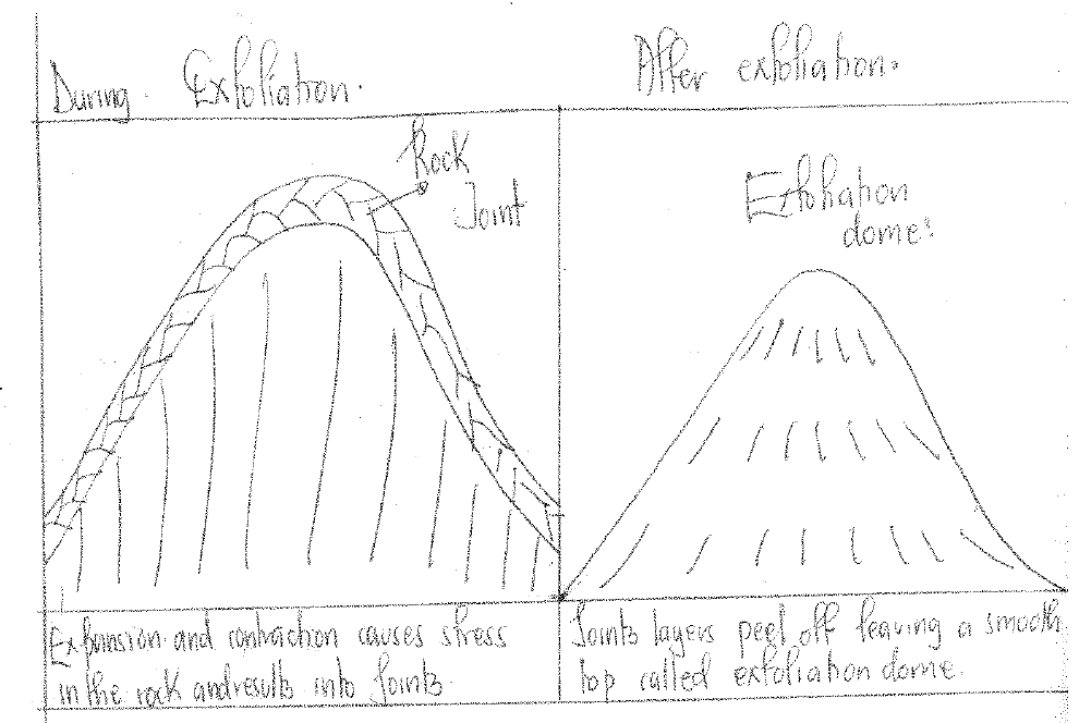
- pg. 75
LANDFORMS RESULTING FROM CHEMICAL WEATHERING
1. Grikes and clints
Grikes are deep narrow grooves / trenches in a limestone area.
They are formed as a result of chemical weathering especially carbonation weathering down
the surface of these rocks in the elongated cracks / joints.
They are formed when carbonic acid enters the permeable jointed limestone rocks and the
joints are attacked and some rock particles dissolved away by carbonation. This expands the
joints and open up inform of valleys / trenches called Grikes. While the limestone rocks
which are not affected by weathering and remain standing up between the adjacent Grikes,
become ribs called dints. Examples can be seen at Mweya Peninsular in Queen Elizabeth
National Park, Sukuru hills in Tororo, Wazo hills in Tanzania and Kambe Kilifi in Kenya.

- pg. 76
2. Karst landforms
These are landforms which form in limestone areas. They include;-
(a) Caves.
These are horizontal cylindrical chambers in a limestone region. They are formed as a
result of rainwater or underground streams, dissolving limestone underneath and
washing it away in a solution form, leaving behind horizontal cylindrical chambers
known as limestone caves.
Diagram:

- pg. 77
(b) Stalactites.
These are finger like protrusions/projections of solidified calcium carbonate on the roof of a
chemically weathered limestone cave. It is formed when water enters a limestone rock
(carbonic acid dissolved by rain water). It dissolves some of the materials turning it into a
calcium bicarbonate solution which begins to leak through the roof of the cave. Later when
water evaporates, it leaves behind hardened protrusions of the former leaking solution
which hangs up on the roof of the cave called stalactites.
(c) Stalagmites
These are finger like protrusions of calcium carbonate on the floor of the limestone cave.
They are formed from accumulation of the leaking calcium bi-carbonate solution and
accumulate at the base and form finger like projections called stalagmites
(d) Pillars
These are walls of solidified calcium carbonate connecting the roof cave to the cave base.
They are formed when stalactites and stalagmites join.
e.gs. of stalagmites, stalactites, caves and pillars are found in Nyakasura where they are
locally known as “Amabere ga Nyina Mwiru” along the eastern coast of Tanga, Nyanamira in
Kisoro e.t.c
(e) Arena
An arena is a large saurcer shaped depressions on the earth’s surface. They develop in areas
with alternating portions of soft and hard rocks or rocks with different mineralogical
composition e.g. rock salt is weathered in solution.
Limestone and dolomite are decomposed by carbonation and removed leaving behind
circular depressions called arenas.

- pg. 78
(f) Sink hole
These are deep holes with nearly vertical sides leading to the underground cave systems.
They are formed as a result of surface collapse and surface dissolving of limestone, leaving
behind deep holes that penetrate in the caves.
It’s also found where a river disappears underground and where it reappears on the surface.
Diagram:
(g) Dolines
These are shallow depressions / holes with gently sloping sides and are circular in shape
originating from carbonic acids percolating underground at the intersections of major joints,
dissolving the rocks within the joints widening them.
They are also formed when a large number of sink holes join as a result of carbonation and
solution to form a large hollow known as a doline.
(h) Dry valleys
Rivers flowing from non-limestone regions may finally reach limestone rocks region which
are very permeable and may disappear underground, only to re-appear at the end of the
limestone rock. The area between the points where the river appears and re-appears on the
surface is what is called a dry valley.

- pg. 79
LIMESTONE GORGES AND WATERFALLS
A limestone gorge is a deep narrow steep sided river valley produced when the roof of the
cave collapses e.g. of Nyakasura. At the same point normally limestone waterfalls develop at
the same point.
Q1. Examine the influence of weathering on land form development in East Africa.
Q2. Account for the formation of landforms resulting from carbonation.
Approach;
- Define carbonation
- Explain the resultant landforms and how they are formed.
- pg. 80
GLACIATION IN EAST AFRICA.
Glaciation is the process that involves the formation of landforms by the work of moving ice or
snow or glacier.
A glacier is a mass of ice moving outward from an area of accumulation from a highland area to a
low land.
A glacier is composed of small frozen water crystals which are coherently attached to each other.
This normally develops at the point of condensation where temperature is very low on the
mountain tops of East Africa particularly Rwenzori, Kilimanjaro and Kenya.
A glacier is formed as a result of condensation of water on top of a mountain to form firn or neve
which may have air spaces within. But as more snow accumulates on the neve, it gets compacted,
destroying all the air spaces to become a glacier ice.
When a glacier begins moving in a confined valley, it will erode the under lying rock.Hence
completing the process of glaciation.
Ate the edge of a glacier or snow, there is a snow line.
A snow line is the lowest point / margin of a continuous snow cover around a slope.
The extent of a snowline depends on the climatic conditions of an area.
One might, therefore, find a permanent snowline and a temporary one depending on the
temperature in the area.
A permanent snowline is a region of perpetual snow cover beyond which snow does not melt. It
is where snow replacement is greater / higher than snow destruction.
The position of the permanent snow line varies with altitude, latitude, aspect, temperature,
strength of wind, steepness of slope etc.
On the East African Mountains, the permanent snowline is the altitude of 4000metres above sea
level.
A temporary snow line (winter snowline) on the other hand is the one which keeps on changing
according to the changes in climatic conditions.
It is at lower altitude during winter and it may shift as it gets hotter and more cold.
Illustration of a snow line.

- pg. 81
Why glaciers are limited in East Africa
Glaciers in East Africa cover such a small area confined to altitude of 4800m.
The limited coverage of glaciers is due to;
1. Latitudinal location of East Africa;
East Africa lies a stride the equator where the overhead sun keeps the environmental
temperature high and hinders the condensation of the water moisture over most of the
region.
This is contrary to the temperate regions and the polar areas where the overhead sun never
raises temperatures high enough to prevent the formation of glaciers.
2. Altitude;
The altitude of East Africa is such that most of the region is at a low altitude where
environmental temperatures are too high to facilitate the condensation of water moisture.
In fact, condensation is only limited to the land lying 4000 metres above sea level and thus is
why glaciers are limited to only the mountains of East Africa which exceed 4000 metres
above sea level.
3. Steepness of the highlands of East Africa;
Most of the highlands of East Africa are so steep that they are greatly influenced by the
gravitational pull which forces the glaciers downhill and in the process, they melt. Hence
limiting glacier coverage in East Africa.
4. Hot equatorial winds;
East Africa is also characterized by hot equatorial winds which prevent condensation of
water moisture. Hence limiting glaciation in East Africa.
- pg. 82
5. Precipitation;
Glaciers form from precipitation in the form of snow. The greater the precipitation, the
greater the amount of glacial formation.
Mt. Rwenzori has the greatest number of glaciers due to its much higher precipitation.
Conversely, the limited number of glaciers on Mt. Kilimanjaro is due to low annual precipitation,
yet one would expect it to be having more glaciers than Rwenzori because it is the tallest.
6. Global warming;
The World temperatures are gradually warming due to several reasons ie deforestation,
industrialization etc.
It is estimated that since 1950, the World temperature have risen by 2.5
0
C. This has had the
effect of melting away glaciers. Glaciers on Mt. Rwenzori for example have retreated by more
than 10 metres since 1906.
7. Ice ward effect;
Glaciers only occur on the wind ward side of mountains and very little on the ice-ward side
due to the warm and dry descending winds on the ice-ward side. Hence causing no
precipitation and eventually glacier formation.
8. Aspect;
East Africa is located within the tropics. Hence limited influence of aspect ie no protection of
slopes from direct heating by the sun.
9. Most of the precipitation received in East Africa is in form of rain not snow. This limits
glacier formation.
10. Volcanicity along mountains;
Most Volcanic mountains are warm eg mountains Elgon and Kirimanjaro such warm
conditions limits the accumulation of glaciers.
FACTORS INFLUENCING THE FORMATION / OCCURANCE OF GLACIERS IN EAST AFRICA.
1. Altitude, in East Africa, areas above 4700m.a.s.level,have low temperatures which
facilitate snow fall and permanent snow cover. The 4700m, is the permanent snow line
above which snow can not melt.
2. Relief/ topography
- The valleys and depressions on the highlands, facilitate ice accumulation.
- The steep and gentle slopes, encourage the movement of ice downwards.
3.Climate, glaciated mountains in East Africa, receive a lot of rainfall which form snow from
which glaciers are formed.
- Low temperatures which fall below freezing point, facilitate freezing and thawing which results
into ice formation.

- pg. 83
4. Rate of accumulating and melting ,influence ice formation.ie when accumulation exceeds
melting, ice formation rate is greatest.
5. Availability of thick vegetation cover.In E. Africa, highland vegetation contributes to the high
rate of transpiration, leading tohigh water vapour content. Thus facilitating ice formation.
GLACIAL EROSION AND ASSOCIATED FEATURES
The major processes of glacial erosion include;
(i). Plucking
This involves the warning off, tearing, grinding, and removal of rock fragments along the
channel / landscape as glacier moves down the slope by the moving mass of mass of ice
characterized by a heavy force that erodes the sides and the bases.
The weight of the glaciers exerts a force on the landscape and the glacier starts moving. The
force drags off the protruding loose rock fragments leading to the formation of several features.
(ii). Abrasion
This is the process of glaciations that involves the wearing, grinding, tearing and weakening of
the surface of the rock under Neath the glacier through grinding action of the material
embedded in the glacier e.g. boulders and pebbles. These are carried in the glacier and they
are used as grinding tools to erode the channel. As the glacier moves, down slope, it’s lowered
inform of boulders and pebbles scratch or polish the channel to create deep grooves. The
glacier experiences the freeze thaw action.
(iii). Frost shuttering.
This involves the expansion and breaking up of rocks due to extreme pressure created by
freezing water/ snow or ice within the jointed rocks. When glaciers form within the jointed
rock, they exert a great pressure on the sides of the joints leading to a break up hence forming
deep grooves and in some cases they form lakes.
(iv). Basal sapping
This involves the breaking up of rocks with alternate freezing and thawing of water at the
bottom of the cracks and between the mass on the side of the floor of the valley. This leads to
the disintegration of the floor of the existing rocks leading to the formation of different features.
(v). Rotational movement
This is a downhill movement of glaciers which is like landslides the glacier pivots around a
certain point /along a pre-existing depression causing undercutting and over deepening of the
pre-existing depression to form features like cirques. The increase in pressure is responsible for
the over deepening of the features like cirque floor.
These processes result into prominent erosional features, the most important of which
include the following; hanging valleys, U-shaped valleys, Cirque, pyramidal peaks etc.

- pg. 84
1. U-shaped valleys / Glacial trough;
As a glacier moves through a V-shaped valley, it erodes the sides and bottom of the valley by
plucking out the inter-locking spurs / rocks that might have become frozen in the glacier.
Also through abrasion, the originally V-shaped valley, its floor is grounded by the rocks that
are embedded in the glacier and it becomes straightened and levelled. So the valley attains an
open U-shape. Thus forming a U-shaped valley as illustrated below.
The river valley which was V-shaped becomes U-shaped with straight endes and a wide flat bed
/ floor.
Examples of –shaped valleys in East Africa include
- The valley of R. Bujuku, Luzibule, Bukusu, Kamusoso.
- Upper part of R. Mobutu around Mt. Rwenzori.
- The river valley of R. Teleki on Mt. Kenya.
2. Hanging valleys;
The main glacial valley / trough on a mountain usually has tributary valleys on the sides.
Glacial erosional processes of plucking and abrasion also take place in these tributary valleys
but at a much slower rate than in the main glacial trough where plucking and abrasion are
greatest due to the too much weight and size of the main glacier.

- pg. 85
As a result, the tributary valleys are left hanging above the main valley and their water joins
the main glacial trough by means of a water fall as shown in the diagram
Eg on Mt. Kenya, the two water falls formed by over deepening of the North Liki valley and
the Hanging Valley from which a tributary joins R. Nithi.
3. Corrie (Cirque)
These are steep-sided, deep arm chair shaped depressions cut into valley heads and
mountain sides.
It is formed as a result of accumulation of a glaciers into a pre-existing depression / hallow or
basin that it erodes through plucking in the back wall that steepens its sides and widens the
depression.
When the ice at the base of the glacier freezes into the crevices / cracks with in the walls of
the depression, blocks are plucked out / torn and removed by the moving ice / glaciers. This
process causes more stress in the rocks making the joints to enlarge and create new ones.
Freeze and thaw activities are increased. Thus widening the depression further.
Abrasion in the floor of the depression deepens the basin. This occurs when the debris frozen
into the base of the glacier is dragged over the rock floor. The floor is scrapped and scoured
with deep grooves and striations.

- pg. 86
Basal sapping / rotational slip (disintegration of rocks along the back wall of a cirque due to
melt water, enables alternate freezing and thawing to shutter the rock.
Thus deepening and widening the basin further.
Back wall recession also widens the basin further.
The resultant land forms is the cirque or corrie.
The hallow may later be filled with water to form a small circular lake called a Tarn (curm)
Examples include Lac Du Speke, Catherine, Blunc on Mt. Rwenzori, L.Honel, Teleki Tarn,
Thompson Tan, Simba Tarn on Mt. Kenya and Mawezi Tarn and Karanga Tarn on Mt.
Kilimajaro.
PYRAMIDAL PEAKS / HORNS
It is a horn like steep sided feature or sharp rock pinnacle which is steep sided surrounded by a
series of radiating aretes.
They are formed by headward erosion of corries (due to backwall recession) from all sides into a
single mountain or hill.
Plucking, backwall recession and basal sapping in the cirques cause the cirques to extend
backwards into the mountain which leads to a reduction of the area of comparatively smooth
relief which existed before glaciation.

- pg. 87
Examples include;
Margheritta, Baker, Alexandria, Speke, Stanley,Lugidi on Mt. Ruwenzori and Nelion,
Point Piggot, Point John and on Mt. Kenya and Kibo on Mt. Kilimanjaro.
ARETES
These are narrow steep sided rocky ridges (knife like) that separate two cirques.It is formed by
backwall recession of cirques into the mountain sides. Two adjacent cirquesreceede backwards
and form an arête as seen on the diagram below
Diagram of an Arete

- pg. 88
Examples are found on the foot hills of Mt. Rwenzori, one radiating into Bujuku valley.
EROSIONAL LOWLAND GLACIAL LAND FORMS
1. Rocheemontonnee
These are rounded rock masses which are smooth and gently sloping in the sides where the
glacier was coming from ie upstream side and rough or rugged and steep on the down
streamside.
They are formed as a result of abrasion smoothening the upstream side by stones embedded
in the ice and plucking (tearing and roughening) the down stream side the stones / blocks
which are sufficiently loosened by development of joints and elongated in the direction of ice
movement.
A large rochemountonne sevensevenmetres long is found on the floor of Mobuku valley on
Mt. Rwenzori and on Kenya along the Gorges valley.
CRAG AND TAIL
Is an outcrop of elongated rock mass which is formed when a glacier meets a resistant rock /
obstacle in its way which is protecting a soft rock on the lee ward side. The glacier will erode the
sides with in reach by plucking and abrasion and part of the eroded material deposited behind
the obstacle.
The resistant rock forms the crag while the soft rock and deposited materials form the tail.

- pg. 89
Numerous examples are found on Mt. Kirimanjaro where cones have been glaciated to form crag
and tail land forms.
7. Rock steps;
These are bench like or step like features that form in the main glacial trough.
Formed when the tributary glacier joins the main glacier, and the additional weight of ice in the
main glacier causes it to cut deeper by plucking and abrasion at the point of convergence to form
rock steps e.g on Mt. Kenya the upper part of the Gorges valley as far down as Vivienne falls, is
divided into sections by four rock steps.
1. Rock basins
These are small long depressions on the floor / bed of a glacial trough.
Formed as a result of the uneven excavation of the bed rock of the glacial valleys by abrasion
and plucking due to the varying weight of the glacier or differences in rock types, may scour
out shallow or deep depression on the valley floor called rock basins eg on the second rock
step of the gorges valley, the Nithi river is interrupted by a small water fall, below which,
there is a rock basin by L. Michaelson.
- pg. 90
Striations or crevasses
These are irregular cracks that tend to open up where a glacier negotiates a bend or a
precipitous slope due to plucking.
Truncated spurs
These are formed when inter-locking spurs in glaciated regions are eroded into straight steep
sides by plucking and abrasion.
Such features occur around Margherita and Speke peaks on Mt. Rwenzori.
Gendarmes
Is a land form similar to pyramidal peaks. They have sharp rock penades rising above aretes.
They are developed by resistant rocks which remain uneroded along an arête.
Fiords
Is a drowned glaciated river valley / mouth bordered by steepsided parallel walls.
Before submergence, a river has interlocking spurs, which are plucked out by the glaciers to
make the valley walls steep and abrasion straightens them further.
ROCK BENCHES
These are features lying above the steep walls of a glacial trough on U-shaped valleys.
They are formed when a glacier does not occupy the entire valley, it deepens its valley through
the erosional processes of plucking and abrasion on the valley floor, creating a valley within a
valley, leaving parts of the former Valley floor above, forming a beach like feature.
GLACIAL LANDFORMS RESULTING FROM GLACIAL DEPOSITION IN THE LOWLANDS
In the low lands, most glacial landforms are a result of till deposition.
As ice sheets and glaciers move down slope, they erode and transport a lot of moraine which
they deposit down in the valleys / low lands to form numerous landforms which include;
1. Till plains
Is an extensive area of monotonous low relief covered by rocks boulders and clays deposited
by glaciers, burying former hills and valleys egTeleki valley and on Mt. Kenya, Mobuku valley
on Mt. Rwenzori.
2. Erratics / boulders;
These are rock boulders transported by moving ice for a long distance and deposited on a till
plain.

- pg. 91
3. Eskers
These are long winding steep sided ridges lying parallel to the direction of ice movement at
right angles to the ice front.
- represent original course of once subglacial streams.
- ridges may be broken by gaps variable in height.
Process of formation (is uncertain)
- perhaps by stagnant ice sheets under hydrostatic pressures. hence develops melt water
streams flowing with the ice, following permanent subglacial tunnels, thereby deposition
within tunnels.
- deglaciation / ice retreat released less water protecting the eskers.
- glavel materials remained in the stream bed with the outer parts collapsed forming eskers.
Possibly
- The existing permant glacial tunnels being chocked / blocked by ice.
- Followed by massive deposition, filling the tunnel headwards.
- Deglaciation / melt water revealed the esker eg along r. Nithi in Gorges valley and along
Teleki valley on Mt. Kenya.
Beaded Esker (Broad ridges, humplike or beaded like)
- Formed at regular intervals.
- Process of formation is uncertain.
- Perhaps at the outwash cone or firn from the mouth of the tunnel at the ice front.
- It is broken by the gravel ridge deposits when ice retreated.
- Probably recession of the ice front at intervals.
- This caused broadening of the esker during these halts.
- Streams from within the ice built up bigger fan broadening the esker.
- Beads therefore represent deltas formed at the ice front during halts in recession.
- The parallel to the direction of the ice movement.
Examples are river Nithi Gorges valley, Mobuku valley etc.
Kame Terrace
These are narrow flat-topped terrace like ridges of sand and gravel along the valley sides.
- pg. 92
Process of formation
- Left absorbed by the rocks on the valley side / wall melt the ice in contact with it.
- Melt water from streams which occupy the trough between the glacier and its enclosing
valley wall.
- Deposition of sand and gravel from melt water occupied the trough between the glacier and
its enclosing valley.
- Deglaciation / ice retreat on the valley side made deposition to collapse at the front.
- Retained sufficient flatness adjacent to the valley sides to form a kame terrace.
Examples are Kamusoso valley on Mt. Rwenzori and Hobley valley on Mt. Kenya.
Kame Moraine
Irregular undulating mounds of bedded sand and gravel deposited randomly
(cone fans and deltas)
- They are arranged in a chaotic and complicated manner.
- Process of development is due to melt water from long stagnant and slowly decaying ice
sheets eg at the end of tidal glacier on Mt. Kenya and Moore glacier on Mt. Rwenzori.
Kettle Holes
- Circular holes in glaciated drift.
- Blocks of ice detached / left behind during recession.
- Ice blocks melted leaving enclosed circular depressions.
- They may be occupied by water forming a kettle lake.
egmahoma kettle on mt.Rwenzori.
Outwashed plains
These are wide gently sloping plains of gravel sand, clay and silt.
- Formed when melt waters from a stagnant glacier carry and deposit sorted materials near
the mouth of a glacier and further down slope eg between Kibo and Mawezi on Mt.
Kilimanjaro, Mobuku and Buguku valleys on Mt. Rwenzori.
Drumlins
These are low rounded elongated hills of glacial deposits usually up to 1km long and about 30-
50 cm high.
They are made from ground moraine which has been made longer in the direction that the ice is
moving by the ice passing over it and thus compressing it.
- Composed of sand and little clay and occurs in sort of rythmetrical pattern in till plains in
large groups or swarms near to the edge of the highland.
- Drumlins are, therefore, characterized by swarms, ponds and marshes, water logged
mealows, existing in the intervening depressions.
Formation process is very uncertain;

- pg. 93
- Probably by friction between the ground moraine and the rock below which may become too
great for the ice to overcome and so the moraine tends to collect in the uneven mounds
under the ice.
- Most drumlins have steeper upstream ends made up of either till or rock core and a gentle
slope at the down stream end.
- They are common in areas where the till plain suddenly widens eg South Africa near
Kimberly, north European plain of Germany, mud valley of Scotland, Northern Ireland, in
Gorges valley and Teleki valley
Lateral moraines
These are materials (debris) carried and deposited along the sides of a glacial trough and tend to
form elongated ridges on the glaciers surface.
When it forms, it protects the glacier below from melting.
When the ice melts, this material is deposited on the sides / edges of the glacial trough floor.
Examples can be seen at Bujuku, Mubuku and Kamusoso trough on Mt. Rwenzori.

- pg. 94
Terminal moraines (moraine ridge)
These are moraines formed at the glaciated slope forming an embarkment at the point where a
glacier on the slope ends. In most cases, moraine ridges are found at the end of the ice sheets.
They are most common in temperate regions where the land scape is not very steep.
Medial moraines
These occur when two glaciers join ie when the lateral moraines of the inner sides of both
glaciers join / meet to form a medial moraine.

- pg. 95
7.0 MAPWORK AND PHOTOGRAPHIC INTERPRETATION
- pg. 96
Map reading is a science that deals with the reading of maps and the ability to interpret the
geographical phenomena on a map.
7.1 LOCATING FEATURES ON THE MAP EXTRACT
Features on the map can be located using 3 methods namely;
- Use of place names,
- Grid reference and
- Use of latitudes and longitudes
Use of place names
This method / skill involves looking for the name of a geographical feature / phenomena.
Use of Grid references to locate features
We use a formular E.N when locating features where each stands for eastings and north for
northings.
Illustration:
Locating features using latitudes and longitudes on a map
(a) Determining hemisphere on a map.
Look for the latitude figures on a map and determine the direction in which they are
increasing . If they are increasing northwards, then the place is located in the northern
hemisphere and if they are increasing southwards then the place is located in the southern
hemisphere.
Then write your answer considering the latitude figures and the direction in which they are
increasing as evidence.
Eg Apoka is located in the northern hemisphere because of the presence of the latitude lines
increasing northwards.
Describing location of the area shown on a map
Describe the location of Apoka.
- Use both latitudes and longitudes
Apoka is located between latitude 3
o
35
1
and 3
o
45 north of the equator and longitude 33
o
40
and 33
o
45 east of the Greenwich.
Locating places using bearing on a map
What is the bearing of Martha from Phionah?
- Locate the two points.
- Draw a straight line linking the two places
- Draw a compass at the point which is at “from”
- Then use a protractor to determine the bearing.
- Write the bearing with 3 figures
- Include the direction.
Q1. What is the bearing of Geremech trigonometrical station from Kareki hill?
196
o
7.2 CALCULATING SKILLS

- pg. 97
E.g. Calculating: - Distance
- Area
- Height of hill
- Amplitude
- Horizontal equivalent
- Gradient of the slope of a curve
- Trend
- De’tour index
- Vertical interval
(i) Calculating the vertical interval on the map
VI = Difference between two close contours
= 4500 – 4450
= 50ft
(ii) Amplitude
Amplitude = Highest point – Lowest point
(Look for the highest trigonometrical station and highest contour)
Amplitude = 5528ft – 2250ft
= 3278ft
(iii) Height of the hill
Height of hill = last numbered contour + VI No. of unnumbered contours
=
= 3400 + (50 4)
= 3400 + 200
= 3600 ft
(iv) Distance
Establishing distance along a curve
Procedure:-
- Locate the curve whose distance you are asked to establish.
- Mark the two points between which you are to establish the distance.
- Get a thread, mark the beginning point of the thread, place the thread on the curve on
the beginning point and go on stretching it along the curve upto the end and mark the
end point on the thread.
- Transfer the thread on the measuring scale and establish the distance in kilometres.
- Establish the distance covered by the dry weather road.
= 8km

- pg. 98
(v) Area
Area = No. of full squares +
Calculate the area, east of the dry weather road
Full squares = 3
Half squares =
Area = 3 + 8
= 11 squares
Since area = 11 squares
Where 1 square = 1km
2
Hence Area =
Thus area =
(vi) Horizontal equivalent
Horizontal equivalent =
Procedure:
- Locate the curve and mark the two points between which you are asked to calculate
the horizontal equivalent.
- Get a thread and place it along the two points
- Establish that distance on a curve by placing it on a ruler in cm.
- Substitute that horizontal distance in the formula
- Horizontal equivalent =
= 8km
(vii) Gradient of the slope of the curve
Gradient of the slope of the curve =
Procedure:
- Locate the curve whose gradient of the slope you are to calculate.
- Mark the two points.
- Place a thread along the curve between the two points marked
- Transfer the thread on the scale and establish the equivalent (distance in km0 and
substitute it in the method.
- Then for amplitude get the highest and lowest contours that cross the curve
between the two points on the curve, get their difference and substitute in the
method, then calculate the gradient of the slope of the curve.
Gradient of the slope of the curve =

- pg. 99
=
=
= 1.3
(viii) Trend
Calculating / determine the curve.
i.e. Calculate the trend of R. Athieno between the two confluences.
Procedure:
- Locate the curve (R. Athieno)
- Mark the two points on the curve.
- Draw a straight line linking the two points.
- Determine the mid-point of the straight line.
- Draw a compass at the mid-point.
- Use the protractor to measure the two angles.
- Also determine the direction.
Diagram:
075
o
North East – 255
o
south west
(i) Determine the trend of Kyaka county boundary.
Trend of Kyaka county boundary = 090
o
NE – 270
o
SW
(ix) D’tour index
Calculating D’tour index along the curve e.g. calculate the D’tour index of the dry weather
road.
Procedure:
- Locate the curve.
- Mark the two points given or the end points of the curve if no points are given.
- Draw a straight line to join the two points or end points.
- Measure the distance of the curve and the straight line and substitute them into the
formula/method.

- pg. 100
D’tour index
=
=
= 41.7%
7.3 SKETCHING SKILLS
(i) Drawing of sketch maps
(a) Map reduction
- Using a reduction factor.
- Reduce the map of Mpara by 2½ times and draw a sketchmap and on it mark
and name physiographic regions, land use activities, drainage features.
- Measure the length and width.
- Divide the length and width by the reduction factor.
- Draw a new frame using the new length and width obtained.
- Mark and label the features asked on the sketchmap “itself”
Length =
Width =
A REDUCED SKETCHMAP OF MPARA SHOWING PHYSICAL AND MANMADE FEATURES
Calculating a new scale for the reduce sketchmap
New scale = Original scale Reduction of factor
New scale = 1:50,000 2.5
New scale = 1:125,000

- pg. 101
MAP REDUCTION USING A NEW SCALE
Given the new scale, 1:200.000, draw a sketch map of Mpara and on it mark and name the
physical and manmade features.
Procedure:
- Compare the original and new scale.
- If the new scale is bigger than the original then you are being asked to reduce the map.
- Then 1
st
find the reduction factor.
Reduction factor =
=
=
= 4 times
- Then measure the length and width of the frame and divide them by the reduction factor
obtained, then draw a new frame using the new length and width calculated.
- Include all the marginal information.
MAP REDUCTION USING A PERCENTAGE
Qn. Reduce the map of Mpara by 40% and draw a sketchmap and on it mark and name
physical and man-made features.
- Measure the length and width of the frame and multiply them by the given percentage
e.g.
L =
W =
MAP REDUCTION GIVEN NORTHING
Draw a sketchmap of Mpara and on it mark and name.
Procedure:
- Determine the shape of the frame and draw a similar frame either rectangular or square
form.
N.B: your frame should cover atleast half of the page.
A sketch map of Mpara showing physical and manmade features given nothing.

- pg. 102
MAP ENLARGEMENT
(a) Using an enlargement factor
- Enlarge the area east of easting 75
o
and south of northing 42 by 3 times and draw a sketch
map and on it mark and name physical and manmade features.
- Locate the given area.
- Measure the length and width of the area.
- Multiply the length and width with the enlargement factor.
- Draw a new frame using the new width obtained.
- Mark and name the features.
- Include the marginal information.
Sketchmap of Mpara showing physical and manmade features of area east of easting 75
o
and
south of northing 42 by 2 times.
(b) Calculating new scale for enlarged sketchmaps.
Qn. Given the new sale 1:25,000, draw a sketchmap of the area above and on it
mark and name physical and manmade features.
Procedure:
- Compare the new and the original scale.
- If the new scale is smaller, then you are being asked to enlarge.
- Then calculate the enlargement factor.
Enlargement factor =
=
=
- Then multiply the length and width of the given area by the scale factor obtained ie 2 in this
case.
(i) A reduced sketchmap of Mpara showing physical and manmade feature.
Length =
Width =
(ii) A sketchmap of Mpara showing physical and manmade feature
DRAWING A SKETCHMAP USING A TRACING PAPER
Procedure:
- Locate the area given on the map.

- pg. 103
- Mark the area using stars.
- Place a tracing paper on the area marked.
- Mark the points marked on the map extract on a tracing paper.
- Trace the features asked and name them on the tracing paper.
- Draw a frame on the tracing paper joining the marked points.
- Draw a compass on the tracing paper.
- Number your work accordingly.
Qn. Using a tracing paper, draw a sketchmap of the area east of easting of 70 and
south of northing 47 and on it mark and name relief features, drainage features,
communication routes, settlement and vegetation type.
Drawing of cross-sections / line transact / Relief sections / Transverse
Procedure:
- Locate the area between which you are being asked to draw a cross-section.
- Mark the area.
- Draw a straight line linking the two points,if the area does not lie along a straight line.
- Place a straight edge of paper on the straight line and mark the area.
- Mark and write the contours that cross the straight edge of paper.
- Mark the features asked on the straight edge of paper.
- Transfer the edge of the paper on a scale and determine the distance of the two points.
- Transfer the straight edge of paper to the graph paper.
- Draw the vertical lines at the points marked.
- Scale the vertical line which should not exceed 6cm.
- Plot the contour values marked on the straight edge of paper.
- Join the dots using a curve with a free hand.
- Shade the area below the curve.
- Plot / Mark and name the features asked / plotted on the straight edge of paper.
- Write a title.
- Number your work.
E.g. Draw a transverse section along northing 50 between eastings 70 and 77 and on it mark and
name;
- Two geomorphological regions.
- Two drainage features.
- Vegetation type.
- Communication line and boundary
CALCULATIONS ON A CROSS SECTION
VI = Difference between two closest points on a cross section.
Amplitude = HP – lP
= 4900 – 3800
= 1100
Gradient of the slope =

- pg. 104
Horizontal equivalent =
Vertical exaggeration =
=
VE =
=
= 16.7
7.4 Description skills
(a) Relief
(i) Describe the relief of Mpara.
(ii) Describe the physiographic features of Mpara.
(iii) Describe the geomorphological set up of Mpara.
(iv) Describe the landscape of Mpara.
Diagrams:-
Mountainous areas / Highlands / uplands
Steep slopesGentle slopes
Low lands / flat landsRidges
SpursConical hills Dome shaped hill
Flat toped hill
Narrow valleyBroad valley
Low landsBasins
- They are indicated by swamps and lakes
Isolated hillsRugged relief
Escarpments / cliff
(b) Drainage
Drainage patterns
- Radial - Centripetal - Dendritic
- River meanders
(iii) Vegetation
Use the key to describe the various vegetation types e.g. forests, scrubs.

- pg. 105
Describe the vegetation of Mpara.
Presence of forests vegetation evidenced by forests in the north, central, south west of Mpara
and south east of Mpara.
There is swampy vegetation evidenced by the papyrus swamps, marshes and bags in the
north east, north, west and south east of Mpara around Kyegegwa boundary, east of Katonga
hunting area.
There is thicket in the north and south east of Mpara as evidence.
Describing land use activities on a map.
- Settlement
- Roads
- Forestry / forest reserve
- Mining / quarrying
- Farm / plantation / Estate / Crop growing
- Fish farming
- Animal rearing
- Industries / factory
- NP and GR
- Hunting area.
- Trading centres / market / shops
- Landing sites.
Economic activities
- Transport due to roads, railways, ferry route, land site.
- Forestry, lumbering evidenced by forests (trees)
- Mining – Quarry evidenced by a quarry or mineral works
- Farming
- Fish farming – ponds, land sites
- Industrialization
- Tourism, NP, GR, lodge
- Hunting – hunting area
- Trade and commerce, roads, market, TC, dense settlements.
- Pastoralism / Ranching – Cattle dips, ranches
Describe the land use activities of Mpara
- There is a road evidenced by a dry weather road in the south east of Mpara.
- There is settlement evidenced by clustered settlement along a footpath at Kanyegenyege,
Waliri in the south east of Mpara.
- There is forestry or forest reserve in Mpara evidenced by forests in the North West, south
west and north east of Mpara.
- There is mining evidenced by several outcrops in the central part of Mpara.
- Presence of hunting area in the south west of Mpara evidenced by Katonga hunting area near
the boundary of Kyaka and Kibale counties in the south west of Mpara.
Describe the economic activities on map Mpara.
- pg. 106
- There is transport due to the presence of roads evidenced by a dry weather road in the south
east of Mpara.
- There is hunting evidenced by Katonga hunting area in the south west of Mpara.
- There is forestry evidenced by forests in the north, south west and south of Mpara.
- There is mining evidenced by the outcrop rock in the central part of Mpara.
Describing settlements on a map.
- Dense settlement in Iringa.
- Moderate
- Scattered / few dispersed
- No, Nil, Absence of settlement.
Describe the settlement of Mpara.
- There is clustered settlement in the south west of Mpara at Rwahunga, Kanyegenyege
evidenced by the present of foot paths.
- There is scattered settlement in the south west of Mpara at Bahura at Bulimga.
- There is no settlement in the west and south west of Mpara.
Describing settlement patterns.
1. Linear settlement pattern where settlements are found along road sides, river banks / sides.
Diagram:
2. Clustered / grouped settlement pattern
These are isolated but connected by foot path.
Diagram:
Grid / planned settlement pattern
This is settlement where are centrally planned near developed transport routes health centres,
education.
It is common in urban centres, plantations and prisons.
Diagram:
Scattered / Dispersed settlement pattern
This is a settlement pattern where settlements are widely spread. It is common in rural areas.
Diagram:
7.5 EXPLAINING RELATIONSHIPS ON A MAP
1. Relief and Drainage
- Identification of the relationship.
Lake Nabugabo occupies a basin in the central in the north.
- Permanent swamps are confined in low lands in the East of Masindi.
- Seasonal swamps are favoured by broad valley in the East, south west.

- pg. 107
- Low lands in the south east are poorly drained.
- Broad valley in south east are poorly drained.
- The basins in the south west are poorly drained.
- Rivers flow from highlands to lowlands/high elevation to lowlands in south and west.
- Rivers flow through narrow valleys in the south east.
- Radial drainage pattern on Fumbyo hill.
- Centripetal drainage pattern is favoured by a basin in south west.
- Bore holes are confined to gentle slopes, low lands and broad valleys.
- Ponds are constructed in lowlands and broad valleys.
2. Relief and Vegetation
- Forests are found on gentle slopes in the North, south west.
- Forests are confined to low lands in the south.
- Papyrus swamps are found in low lands on the east.
- Papyrus swamps are confined to broad valley of the east.
- Crop vegetation is found on gentle slopes on Bojeje Estate.
- Scrubs are found on gentle slopes in the south, south west.
- Scattered trees are found in the low lands in the south east.
3. Drainage and vegetation
- Papyrus swamps, mangrove, trees swamp, marshes, bogbens are favoured by swamps
and found in poorly drained areas.
Forests
Woodlands
Shrub and thicket grow/favoured by good drainage/well developed areas
Scattered trees
Grass
Physical – Human relationships
(i) Communication and Relief
- Loose surface road is following gentle slopes
- Loose surface road is confined to low lands
- Dry weather road confined by the gentle slopes.
- Dry weather road confined by the gentle slopes
- Dry weather road confined by low lands
- Food path is found in:- Steep slopes
- Gentle slopes
- Low lands
(ii) Communication and Drainage
- All communication roads e.g. air strips, dry weather road, air strips, loose surface roads
are constructed in well drained areas.
- Poorly drained areas are covered by foot path.
- Roads cross rivers by use of culverts.
- Roads cross rivers by use of bridges.
- Lakes are crossed by use of ferry routes.
- Roads cross poorly drained areas by use of culverts.
Give reasons for each
relationship
Give reasons in each
case.

- pg. 108
(iii) Settlements and Relief
- Dense settlement are found in low lands.
- Gentle slopes
(iv) Scattered / Few settlements are found on:
- Steep slopes; these slopes have no settlements.
- Low lands have few/scattered settlement.
- Low lands have no settlements.
(v) Settlement and Drainage
- Dense settlement is confined to well drained areas.
- No settlements in swamps.
- No settlements in poorly drained area.
- Lake shores attract a dense population at the landing sites.
- Rivers attract linear settlement.
7.6 PROBLEMS FACED BY THE AREA SHOWN ON A MAP EXTRACT.
NB: Problems are delivered from the nature of relief, vegetation, drainage and land use
types or activities.
(a) Relief
Mountainous / steep slopes encourage soil erosion, landslides, hinder the development of
roads, limit land for settlement and hinder agriculture mechanization.
(b) Low lands lead to flooding, hinder construction of roads especially the poorly drained low
lands.
(c) Forests. Limit land for settlement, limit land for agriculture, pests and diseases, habour
dangerous wild animals which attack man.
(d) Swampy vegetation. Lead to water borne diseases because of the snails that cause bilharzia.
(e) Lakes and rivers result into water borne diseases limit land for agriculture and settlement.
8.0 PHOTOGRAPHIC INTERPRETATION
8.1 Types of photographs
There are two types of photographs namely;
(a) Ground photographs,
(b) Aerial photographs
GROUND PHOTOGRAPHS
These are photographs taken with a ground dash camera. Ground photographs can be divided
into two namely;
- Ground view photographs,
- Ground oblique photographs.
Give reason in each
case.
Give reasons in each
case.

- pg. 109
Ground view photograph are taken when the camera man stands directly infront of the feature
and photographs it whereas ground oblique photograph is taken when a camera man stands on
a raise ground e.g. cliff, tree, infront of it and photographs it.
CHARACTERISTICS OF GROUND PHOTOGRAPH
- The skyline/horizon is visible.
- The features in the fore ground are bigger than those in the background.
- Cover a smaller area.
- Features are clearer.
AERIAL PHOTOGRAPHS
These are photographs taken when the camera man is in an aeroplane / from above. They are
categorized into two namely; Aerial vertical and aerial oblique.
Aerial vertical photographs are photos taken directly above the feature, when the camera is held
at right angle. Only tops of the features are visible, no horizon visible.
Aerial oblique
Those are photographs taken when the plane approaches the feature and the camera man holds
the camera at an acute angle and photographs the feature of interest. The feature may show
more than one dimension and sky line may sometimes be visible.
GENERAL CHARACTERISTICS OF AERIAL PHOTOGRAPH
- Generally cover a wider area.
- Features are not clear.
- Features are not easy to interprete.
- Show only one dimension.
8.2 Drawing landscape sketch of the photograph/photo sketch / panoramic view of a
photograph.
Procedure:-
- Draw a frame of the same size.
- Divide the photographs into grounds i.e. fore, middle and back ground and then divide them
into sub-grounds as shown below.
- Draw the features in pictorial form only.
- Label the features on the sketch drawing only.
- Never include a compass because it’s not a sketch map.
8.3 DESCRIBING FETURES ON A PHOTOGRAPH
Note: Refer to Map work but give evidence in form of grounds.
- Describing relationships on a photograph.

- pg. 110
- Refer to map work but give evidence in terms of grounds.
- Problems faced on the photograph, refer to map work.
8.4 Area where the photograph was taken from;
- Area depends on the main theme shown on the photograph.
- Give the smallest unit / area possible.
- Avoid giving districts and regions.
Qn.1.Draw a landscape sketch of the area shown in the photograph and on it
mark and label;
(i) Relief regions
(ii) Vegetation types
(iv) Drainage and land use activities
COASTAL GEOMOPHOLOGY
13.0 CORAL REEFS / CORAL ROCKS / CORAL LANDFORMS
Qn. Account for the formation of coral landforms.
These are limestone ridges along the sea shores formed as a result of the deposition and
accumulation of skeletons of tiny marine organisms known as polyps which live in millions of
colonies and have skeletons formed from calcium carbonate contained in the salty sea water.
The tube like skeletons in which the organisms live extend upwards and outwards as old polyps
die and new ones are born.
Coral polyps cannot grow out of water and therefore are formed below the level of low tide.
13.1 CONDITIONS FOR THE GROWTH AND DEVELOPMENT OF CORAL POLYPS / REEFS /
LANDFORMS
- pg. 111
Favourable climate characterized by;Warm temperatures between 20 – 30
o
C within the tropics
between 30
o
north and south of the equator.
- Clear sunlight water to a depth of 60m.
- They grow on the eastern sides of continents where there are warm ocean currents.
- They need salty oxygenated sea water of 27 – 40 parts per 1000 salinity. This acts as
additional food for polyps where they extract calcium carbonate necessary for the formation
of the hard skeletons.
- Abundant planktons which act as food for the polyps.
- They need a shallow extensive continental shelf with a depth of not more than 60m to allow
sunlight penetration and oxygen.
- Existence of clear silt free water away from river mouth where silt laden fresh water empties
into the sea which destabilizes coral formation.
- Sea level changes that cause sub-mergence of coasts.
- Variations in water levels i.e. high and low tides facilitate the death and accumulation of
polyps.
- Presence of solid bedrock to provide a firm foundation.
13.2 PROCESS OF FORMATION
Coral landforms are formed when coral polyps die and the softer parts of their bodies decay
leaving the shells.
The coral shells that are made up of calcium carbonate (limestone) accumulate on the
continental shelf.
With the continued accumulation of skeletons overtime, the coral polyps increase in weight get
compressed, become compacted and cemented to form a consolidated mass of rock called coral
reef.
Other organisms like calcereous, algae and echinoderms help in facilitating the consolidation
process which cements the spaces between the dead corals.
13.3 TYPES OF CORAL LANDFORMS
(1) FRINGING REEFS

- pg. 112
This is a coral platform which forms close or near to the coast and is joined to the coast and is
separated from the coast by a narrow and shallow lagoon.
It fringes along the coast. It is steeper seawards. Examples include, Shanzu beach north of
Mombasa, Kilifi and Dar-es-Salaam along the coast of East Africa.
Diagram:
(2) BARRIER REEF
These are coral platforms which form far away from the coast. They are connected to the
coast. They enclose a wider and deeper lagoon. Examples exist around Madagascar on
Mayotte Island and the Great Barrier Reef found at the coast of Queen’s land in Australia.
Diagram:

- pg. 113
(3) ATOLL REEFS
These are usually circular /horse shoe shaped. They are often found in the middle of oceans.
They are not connected to the coast.
They surround a fairly deep lagoon but generally broken in pieces by narrow channel inlets.
Examples include, Chumbe Island near Zanzibar, Shimon in Southern Kenya and Aldabara
reef located 700km off the coast of East Africa.
Diagram:
13.4 THEORIES OF FORMATION OF CORAL REEFS
- pg. 114
There is no problem about the origin and growth of fringing reefs. They grow from land towards
the sea.
However, there is a problem attached to the origin of barrier and atoll reefs that grow up from
great depth such as 29000 – 30,000 feet, yet coral can only grow from 60m deep. The depth is far
below the level at which coral can grow.
Three theories to explain the origin of atoll and barrier reefs have been advanced by Darwin,
Murray and Daly.
13.5DARWIN’S THEORY OF SUBSIDENCE
Darwin states that the growth of atoll and barrier reefs is due to subsidence of land masses.
He suggests that initially volcanic activity led to the formation of a volcanic cone / island due to
the accumulation of magma along a vent in the ocean.
Polyps colonized the Flanks/edges of a volcanic cone/island and as they died their skeletons
accumulated on the volcanic platform. They were eventually compacted, compressed and
cemented into a hard rock called a fringing reef.
The volcanic island gradually / slowly subsided as a result of isostatic . re-adjustment which
followed the eruption.
However, the fringing reefs on the flanks of the volcanic cone continued to grow upwards and
outwards keeping pace with the subsidence of the volcano.
Such a subsidence increased the water depth beyond the level at which coral polyps can
grow/survive.
Coral polyps subsequently died while some tried to grow to keep pace with the changes in the
water depth.
Since coral / growth is more concentrated on the out side of the reef where food is plenty, a big
rim will be formed.

- pg. 115
On the other hand the inner side of the reef becomes increasingly deeper and wider as the reef
becomes bigger and the coast of the volcano subsides further. At this point, a fringing reef has
turned into a barrier reef.
Finally with continued subsidence of the volcanic cone, there will come a time when it is only the
coral which is visible, the volcanic cone being completely submerged. This visible coral will form
a ring of coral reefs with no island in the middle. This becomes an atoll.
Note: The transformation took place because the upward accumulation of corals was
able to keep pace with the rate of subsidence of the volcano and maintain itself at
the water surface.
Diagram:
FACTS TO SUPPORT DARWIN’S THEORY
- Some coasts within close proximity to barrier and atoll reefs reveal features of submergence
like rias and estuaries e.g. the East African coast and at the same time, atoll and barrier reefs
are found in the Indian Ocean close to the coast of East Africa.
- There is presence of volcanic islands off the East African coast in the Indian Ocean and yet
there are atoll and barrier reefs.
- There are also other features caused by submergence e.g. mud flats at Mombasa and
Dalmatian coastline near Pemba.
- pg. 116
FACTS DISAPROVING DARWIN’S THEORY
- Some atolls and barrier reefs occur near coasts that have been uplifted and where no signs of
subsidence are apparent yet he bases his theory on subsidence.
- In some borings i.e. digging down the ocean floor, no volcanic rocks were found on Bikini
Island, sedimentary rocks were found instead.
- The theory does not explain why some corals are found at great depth of over 1000m where
coral polyps cannot survive.
13.6 MURRAY’S THEORY OF ANTECEDENT
Murray assumed the existence of a stable submarine platform on which pelagic deposits were
deposited upto a depth of not more than 60m after which coral grew.
Barrier and atoll reefs began life / formation on these platform / submarine hills as fringing
reefs by growing upwards and outwards.
As the reefs grew upwards and outwards, it was pounded by waves so that masses of coral
fragments accumulated on the sea ward side where they were commented into hard rocks to
form barrier reefs.
The corals on the inner side died due to lack of food and their skeletons become dissolved such
that a deeper and wider lagoon is formed inside the reef to form an atoll.
In the process, the fringing reef transformed into a barrier reef and finally into an atoll.
Diagram
- pg. 117
FACTS TO SUPPORT MURRAY’S THEORY
- Fragments of coral do exist in the lagoons between reefs.
- Through boring, sediments were found underneath at a depth of 2000ft down the Bikini
island. This is in line with Murray’s theory.
- The steepness of the reef is greater on the seaward side than on the leeward side.
- Atolls have been established to rest on truncated volcanic cones as was suggested by Murray
e.g. at Aldabara.
- Existence of fringing and barrier reefs on Mayotte islands between Madagascar and
Mozambique.
- Presence of atolls around Aldabara.
- More pronounced coral growth on the seaward side than the leeward side.
WEAKNESSES OF THE THEORY
- Coral reefs are too hard to be worn down as suggested by Murray.
- Sand accumulates very slowly and it is unlikely that it would form a platform moreover with
the necessary steepness.
- The theory does not explain the great thickness of the corals.
- The lagoons enclosed by atoll and barrier reefs are too big that it would be difficult for water
to dissolve a hard rock to this depth.
13.7 DALY’S DEGLACIATION THEORY
He based his theory on sea level changes.
He suggested that the level of the sea was greatly lowered during the cold glacial times and
therefore periglacial coral reefs and other islands were eroded by waves to the sea level of that
time. This produced flat or gently sloping surfaces.
Coral polyps colonized these platforms to form fringing reefs when the temperatures of the sea
increased and ice sheets slowly returned their melt water to the oceans causing a rise in the sea
level.
The deglaciation which led to a rise in the sea level made the fringing reefs continue to grow
upwards and outwards thus transforming into barrier reefs and finally into atoll reefs when the
hills were completely submerged.
- pg. 118
The transformation took place because the upward and outward growth of coral was able to
keep pace with the rate in the rise of the sea level and maintained themselves at the water
surface.
Diagram
FACTS TO SUPPORT DALY’S THEORY
- The great depth at which coral is formed through boring is explained because it is believed
that corals grow on top of dead coral.
- Coral can grow upwards at a ratio of 1 foot per 10 years. This means that it would keep pace
with the rise of the sea level.
- Features of glaciation have been formed e.g. fiords and yet some of the coral island are found
in the Pacific Ocean.
- It was discovered that we have had four ice ages. So the level of the sea has therefore gone up
and down four times.
- During all these sea level changes, coral would have happened as suggested by Daly.
Moreover most of the evidences through boring seem to be in favour of changes in the sea
level.
- Atoll reefs are very steep and this is explained by Daly’s theory since sediments would
accumulate at such steep angels.
FACTS DISPPROVING DALY’S THEORY

- pg. 119
- Scientists have discovered that coral reefs are not easily eroded. They are eroded at a rate of
2mm per 10 years. It is therefore not possible that sub-marine wave cut platforms would be
formed.
Questions:
1. Examine the relevance of Daly’s theory in understanding the origin of coral landforms.
Approach:
- Define coral landforms.
- Conditions
- Process
- Types of coral reefs.
- Describe Daly’s theory.
- Explain the facts to support the theory
2. Assess the relevance of Darwin’s theory in understanding the origin of coral landforms.
Approach:
- Define coral landforms.
- Conditions.
- Processe.
- Types.
- Describe Darwn’s theory.
- Explain facts to support his theory.
- Explain the facts disapproving his theory.
14.0 WAVE ACTION
Waves are undulations or ripples on the surface of the sea caused by the blowing of wind across
the water.
Waves are generated by wind form when there is friction between moving wind and water
surface. This friction causes the circular movement of water particles which move vertically
towards the coast as waves.
Waves can also be caused by marine earthquakes (Tsunamies) large submarines, moving ships,
large whales, and marine volcanic eruptions e.t.c.
When a wave enters shallow water, its top falls forward and its water is thrown forward.

- pg. 120
The water thrown up the beach by the breaking waves is called a Swash while the retreat of the
water back to the sea is called a back wash.
The drift of materials carried by waves along the coast as a result of waves breaking at an angle
is called long shore drift.
14.1 TYPES OF WAVES
(1) Destructive waves
These are waves that have a strong back wash and weak swash. They are generated by
strong winds. These waves remove pebbles and sands from the coast and lead to the erosion
of the coast. They have a frequency of 13 – 15 waves per minute.
Diagram:
(2) Constructive waves

- pg. 121
These are waves which have a strong swash and a weak back wash, generated by weak winds
and have a low frequency of 8 waves per minute. They lead to deposition along the coast.
Diagram:
14.2 EROSIVE WORK OF WAVES
Waves erode the coast through several ways / processes like;
(1) Mechanical action / Abrasion / Corrasive action
Boulders, pebbles and sands are thrown with force by the breaking waves against the coast
and these cause under cutting and rock break up leading to the formation of various
landforms.
(2) Hydraulic action
Water thrown against the cliff face by the breaking waves causes air in the cracks and
crevaces to become suddenly compressed. When the waves retreat, the air expands often
explosively. This action causes the rocks to shutter as the cracks become enlarged and
extended. Wave water also has a beating action on the coast which leads to rock break up.
(3) Solution / corrosion
This is a process which involves discharging soluble rock into a solution especially soluble
rocks like limestone.
(4) Attrition
This is a process where boulders pebbles e.t.c. rub against each other and bigger particles
reduce in size.
14.3 FEATURES PRODUCED BY WAVE ACTION
(1) Notch

- pg. 122
This is a small opening / depression found at the coast/ shore / beach. It is formed when
hydraulic and corrasive action of waves lead to the under cutting of the coast and they
remove a loose wedge from the coast and form a small opening or depression known as a
Notch.. Notches also develop where there are well developed limestone rocks which have
been removed by chemical action (solution of waves). The limestone is dissolved by the wave
salty waters. Where the dissolution has occurred and rocks are turned into a solution there
remains a small opening or depression called a Notch.
(i) Before erosion (ii) After erosion
(2) Cliff
Is a steep rock face along the coast. The continued undercutting by hydraulic and corrasion
action of waves in the Notch combined with sub-aerial mass movement and weathering
which causes the upper part to collapse. The steep rock face formed is known as a cliff.
Diagram:
(3) Wave cut platform
Is the flat low-lying piece of land found at the coast. It is formed when a cliff retreats to form
a bench like feature through the grinding action / corrasive action of materials swept to and
from the coast by the breaking waves. They are visible at low tide and covered by water at
high tide e.g. south of Mombasa.

- pg. 123
Diagram:
(4) Caves
A cave is a horizontal cylindrical hole at the base of the cliff formed by the hydraulic action of
waves enlarging an initial crack (joint in the rock) the impact of the breaking waves by the
hydraulic action exerts enormous pressure in the rock joints causing air in the cracks to be
suddenly compressed. When water retreats, the air expands explosively. The expansion
gradually loosens the rocks and enlarge the cracks. The boulders pebble thrown with force at
the base of the cliff also lead to under cutting and rock break up through corrosive action.
There is a cave at Lutembe beach. Resort beach in Entebbe at Mombasa e.t.c.
Diagram:
(5) Blow hole
Is a vertical cylindrical hole which extends from the end of the cave to the top of the cliff. It is
formed from the hydraulic force of waves spurting high into the air and weaken the joints in
the cave roof so much that a vertical tunnel connecting the cave with the cliff top known as a
blow hole is formed e.g. near Botanical gardens in Entebbe and Kasenyi fish landing site.

- pg. 124
Diagram:
(6) Geo
This is a long narrow sea inlet along the coast. It is formed when there is further erosion by
hydraulic and corrasive actions of waves which forces the cave roof to collapse to form a long
narrow gorge like inlet known as a geo e.g. at Kasenyi.
Diagram:
(5) Bays and headlands
These are indented coasts where headlands refer to projection of the land into the sea and
bays refer to the projections of the sea into the coast. They develop along costs where
resistant and weak rocks alternate. The weak rocks are worn away by hydraulic and

- pg. 125
corrasive action of waves to form bays while the resistant rocks stand up as headlands and
remain projecting into the sea e.g. Entebbe peninsular region has headlands flanked by bays.
Diagram:
Qn. Account for the formation of a stump.
Approach:
- Identify a stump as a wave erosive feature.
- Describe wave erosional processes.
- Indicate that the stump forms in a series of stages beginning with:
- Cliffs which develop on the sides of a headland.
- Then caves at the base of the cliff on the headlands.
- Then arches, then stack and lastly stump.
Arches
An arch is a horizontal cylindrical tunnel or bridge like feature which develops in a headland.
They are formed when two caves develop back to back by the hydraulic and corrasive action of
waves on a headland which ultimately join ,forming a tunnel through the headland known as an
arch.

- pg. 126
Stack
Is a piece of rock standing prominently into the water opposite a headland.
Its formed when hydraulic and corrasive action of waves erode the roof of the arch and it finally
collapses such that the end of the headland is separated from the main headland which stands
up in the water and it is called a stack.
Stump
Is a worn down piece of rock standing prominently into and under the water opposite a
headland but can be visible during low tide. Formed when a stack is worn down by the hydraulic
and abrasive actions of waves.
Examples of bays and headlands; stacks, arches and stumps exist at Kasenyi fish landing site
e.t.c.
14.4 WAVE DEPOSITIONAL FEATURES
Wave deposition occurs through the process of long shore drift.
It’s a process through which materials are moved by the swash and back wash in a zigzag
manner. It occurs where the waves break obliquely and the swash deposits the materials. The
back wash retreats at right angles at the shore. Eventually the deposits accumulate to form wave
depositional features.
BEACH
A beach is a gently sloping platform along the coast or shore composed of accumulated deposits
of sand, shingle and pebbles.
Beaches can be sandy, stony beaches and shingle beaches. Beaches are formed through the
process of the long shore drift where waves deposit sand, shingle and pebbles along the coast to
form a gently sloping platform between the high tide and low tide e.g. Gaba beach, Lido beach.
Diagram
TYPES OF BEACHES
(1) Bay head beach
It is a crescent of sand and shingle formed between two headlands by the long shore drift.
Such as the Lido beach at Entebbe, Nyali beach at Mombasa, Lutembe beach e.t.c.
(2) Barrier beach

- pg. 127
This is a long sand ridge parallel to the coast and separate by a lagoon. It is formed where
waves break some distance from the coast.
(3) Storm beach
This is formed where strong waves deposit coarse materials several metres above the water
level during times of storms.
(4) Beach berms
Is a beach ridge formed on the upper part of some beaches . It is formed by the deposition of
sand and shingle in areas with steep profiles along the shore. They accumulate at the furthest
limit of the wave action.
(5) Beach cusps
Are projections of sand and shingle forming a cone shaped apex pointing seawards. They are
formed by eddies with a powerful swash Scouring coarse materials in the depressions. They
are separated by shallow indentations that face seaward e.g. at Mombasa.
SPITS
A spit is a low narrow ridge of sand and pebbles joined to the coast at one end with the other
end terminating into the sea. It is formed by the process of the long shore drift in areas
around headlands, where sand, shingle and pebbles are deposited growing outwards and
glares into the bay.
Waves swaying obliquely into the bay hit the materials being deposited and therefore the
ends of the spits become hooked or curved.
(1) Hooked / Curved spits
This is formed where waves approach a spit from several directions depositing materials at
right angles, causing it to curve towards the sea as it grows e.g. at Kibanga on L. Victoria in
Buikwe and Tonya point on L. Albert.
Diagram:

- pg. 128
(2) Cuspate spit
This is formed where spits develop from opposite headlands and converge at their apex
where spits begin formation from a headland and keeps on curving until it becomes attached
to the shore / head land again.
BAR
A bar is a low narrow ridge of sand and shingle. They are formed through the process of the
long shore drift when the breaking waves deposit sand materials off shore parallel to the
coast or across a bay enclosing a lagoon.
TYPES OF BARS
(1) Bay Bar
These are formed when deposition of materials begin from a headland as a spit, ultimately
stretches across a bay to the next headland. They are normally broken into by tides and are
therefore are not always continuous.
They enclose a lagoon e.g. Lake Nabugabo.
Diagram:

- pg. 129
OFFSHORE BAR
It is formed when materials are deposited far away on very gently sloping coast where the
continental shelf extends into the sea. The waves transporting the material break at a
distance before reaching the coast thus depositing the material forming on offshore bar.
Diagram:
FORE SHORE BAR
This is formed by the constant accumulation of sand causing the bar to rise above the water
surface.
CUSPATE FORELAND
Is a triangular shaped deposit of sand and shingle projecting seawards. It is formed by the
converging of two spits which enclose a lagoon and this lagoon is later filled with sand and
shingle and may later be colonized by vegetation. A cuspate foreland may later be enlarged by
addition of materials (gravel, shingle and sand) to form beach cusps.
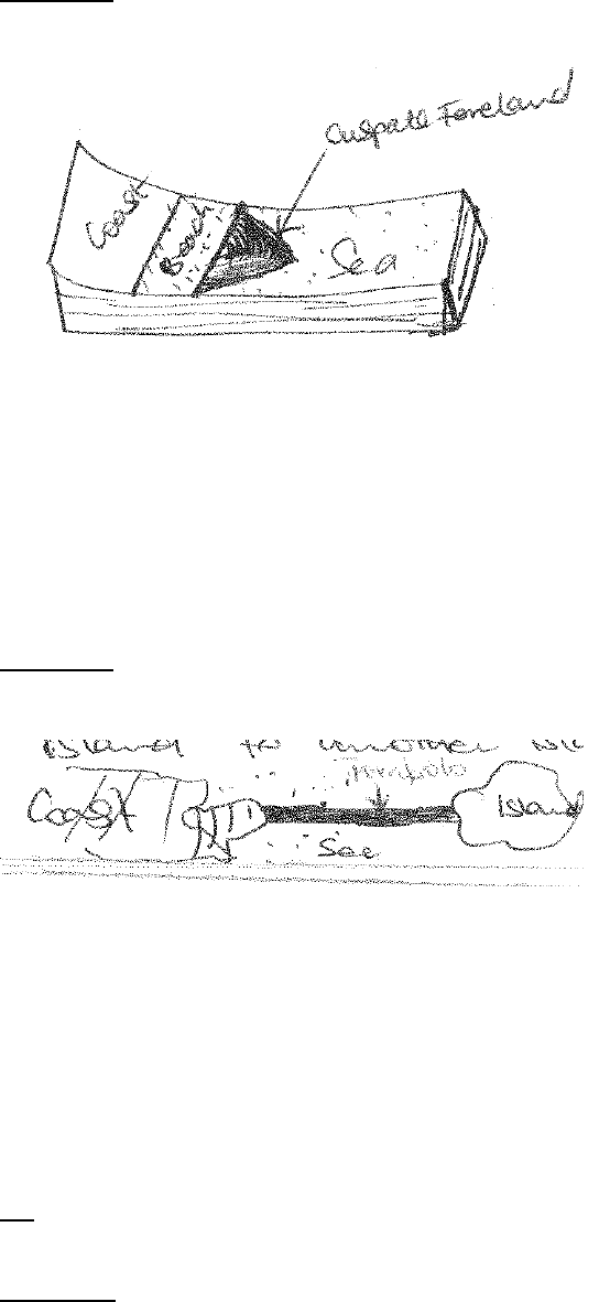
- pg. 130
Diagram:
TOMBOLO
Is a low narrow ridge connecting the coast to an island or one island to another. It is formed
when the deposition of sand begins from a headland as a spit, glares into the sea upto an island.
There used to be a tombolo joining Bukakata in Masaka to Lamu Island and at Kibanga on the
northern shores of L.Victoria
Diagram:
MUD FLATS
These are platforms of mud. They are formed as a result of the long shore drift of waves
transporting and depositing mud and silt which form low-lying platforms of mud known as
mudflats.
Examples exist in Mombasa.
Qn. Examine the influence of long shore drift on landform development in East
Africa.
Approach:
- Define long shore drift.
- Account for the formation of wave depositional features.
- pg. 131
15.0 SEA LEVEL CHANGES / EUSTATISM
15.1 Eustatic movements / Eustatism
This refers to the world wide rise or fall in the level of the sea relative to that of land.
These changes are due to tectonic movements; massive melting of Glaciers e.t.c. These
changes can be positive in the form of submergence or can be negative in form of emergency.
15.2 Isostatic movements
These refer to the rise of fall of the sea level in relation to the land on a local / minor scale.
The changes are due to local earth movements and they affect particular coasts or are from
isostatic adjustments due to unloading or loading of the coast. They also involve positive
movements in form of submergence and negative movements in form of emergency.
15.3 CAUSES OF A RISE IN THE SEA LEVEL / SUBMERGENCE OF COASTLINES /MARINE
TRANSGRESSION
(1) Deglaciation
This is the melting of glaciers. After the Pleistocene period, large masses of glaciers melted,
releasing large amounts of water which drained into the sea. Hence contributing to a rise in
the sea level.
(2) Sedimentation
The presence of many rivers flowing into seas, oceans and lakes which carry large quantities
of sediments and deposit them on the sea floor, displace the waters upwards hence
contributing to a rise in the sea level e.g. R. Rufigi and Tana in the Indian Ocean.
(3) Climatic changes
Climatic changes resulting into increased rainfall lead to the rise in the sea level e.g. 1960’s
in Uganda long heavy rains led to the most lakes rising and submergence of ports.
(4) Rise in sea temperatures
When the sea temperatures rise, water molecules expand which causes the positive
movements in the sea level. The increased temperatures may be due to volcanic activities on
the sea bed.
(5) Earth movements
- pg. 132
Uplifting of the sea bed displaces the sea water upwards hence causing a rise in the sea level.
Subsidence along the coast causes the land to go down and the water level goes up e.g. the
local sinking at Kirindini (Mombasa) contributed to a rise in the level of the sea relative to
the level of land.
(6) Presence of many rivers and streams discharging their water in the seas also leads to the
rise in the sea level.
(7) Global warming
Due to the current trend in the green house affect world temperatures are increasing. This
leads to melting of permanent snow which release large amounts of water into the sea and
oceans.
(8) Isostacy
This involves the wearing away (down) of continental land masses by weathering and
erosion which leads to a fall in the level of land relative to that of the sea leads to a rise in the
sea level relative to that of land.
(9) Contraction of sea floors
Some geologists have suggested that the earth is contracting which means that the sea floors
are also contracting leading to reduced volumes of the ocean basins.
This automatically leads to the rise in the sea level.
(10) Human activities
Like dumping of rubbish, sewage, gabbage, construction of piers and hotels in water, have led
to the rise in the sea level. This involves the dumping of thousands tonnes of hard core
stones, soils and sewage in water which forces the water to be displaced upwards hence a
rise in the sea level.
15.4 CAUSES OF A FALL IN THE SEA LEVEL / NEGATIVE CHANGES (EMERGENCY OF
COAST LINES) / MARINE REGRESSION
(1) Glaciation

- pg. 133
Refers to the formation of large masses of ice; large quantities of water are locked up in form
of ice masses resulting into a fall in the sea level.
(2) Global warming
This has resulted into increased temperatures and depletion of the ozone layer due to the
increase in carbon compounds in the atmosphere hence leading to direct heating of the
earth’s surface leading to excessive evaporation. Hence a fall in the sea level.
(3) Drought
Abnormal prolonged shortages of rainfall have resulted into no water being discharged in
oceans and high evaporation rates hence leading to a fall in the sea level.
(4) Isostacy
The rising of the coastal land relative to the sea leads to a fall in the sea level. This could be
due to deposition at the coast by rivers e.t.c. leads to a fall in the sea level.
(5) Earth movements
Warping or faulting on the sea bed creates depressions there which makes the waters
withdraw from the coastal area to fill the newly created depressions on the sea bed. This
leads to a fall in the sea level. Whereas uplifting along the coast, leads to the rise of land
relative to that of the sea. Hence contributing to a fall in the sea base level.
(6) Presence of many streams/rivers drawing water from the sea / lakes, drain them .Hence
leading to a reduction in the water levels.
(7) Human activities;
Like using too much water from lakes and seas for irrigation, damming of rivers, water for
domestic use, which are the sources of water for the seas and lakes, leads to a fall in the sea
level.
Note: Any movement including a rise in the land relative to that of the sea is
described as negative movements of the sea level and leads to emergency of
coastlines.
The sinking of land relative to the sea is called a positive movement of the sea base level and
leads to the submergence of the coast line.

- pg. 134
There are therefore two basic types of coasts i.e. submerged coasts and emerged coasts. Each
of these coasts can be divided into highland and low land coasts.
15.6 LANDFORMS RESULTING FROM SEA LEVEL CHANGES ON A HIGHLAND COAST
(1) RIAS
A ria is a submerged river valley on the highland coast. Its funnel shaped, wider and deeper
seawards and narrower and shallower landward.
It’s formed when the lower part of the river valley is submerged during the rise in sea level
e.g. R. Mtwala, Tanga, Dar-es-Saalam and Lamu in Tanzania and along the southern shores of
Lake Victoria near Mwanza.
(i) Before submergence
Diagram

- pg. 135
(2) FIORDS
A fiord is a drowned glaciated river valley on a highland coast.
Before glaciation, a river is winding between interlocking spurs but when the valley is filled
with glaciers, the interlocking spurs are eroded and the river valley is changed from a V-
profile to a U-shaped profile and has hanging valleys and truncated spurs, shallow seawards
and deeper landwards. The valleys are excessively steep sided because of glacial erosion.
When such a valley is drowned due to a rise in the sea level, forms a fiord. They form good
sheltered harbours and examples exist in Sweden and Norway.
Formation of fiords
(i) Before glaciation (ii) After glaciation
Diagram Diagram
(3) LONGITUDINAL / DALMATIAN COAST
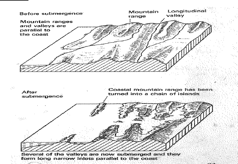
- pg. 136
These are submerged tops of hills / mountains / highlands lying broadly parallel to the coast.
It’s formed when highland regions whose vallies and mountains are parallel to the coast are
submerged during the rise in the sea level.
Highlands appear as a chain of islands called Dalmatian coasts while the drowned valleys
form sounds e.g. the Smith sounds on the shores of Lake Victoria in Mwanza, Bumbuli hills,
south of Bukoba on L. Victoria.
Diagram
(4) PENINSULAR
This is an extensive piece of land projecting into the sea. It’s formed when highlands at right
angles to the coast and the valleys, are submerged, leaving the land projecting into the sea
e.g. Entebbe and Mombasa peninsular.
(5) ISLAND
Is a piece of land surrounded by water in a sea, lake, or ocean. It’s formed when a highland
region is submerged and the parts which are not covered by water, form islands e.g. Ssese
island, Kome in L. Victoria.
15.7 SUBMERGED FEATURES ON LOW LAND COAST
(1) ESTUARIES
- pg. 137
These are submerged / drowned river valleys on a low land coast. They have a V-shaped
cross profile pointing land ward e.g. the mouth of R. Rufigi, Wani along the East African coast,
Mombasa and Kibanga on L. Victoria in Buikwe.
(2) CREEKS
These are drowned river valleys on a low land coast but they are smaller and tidal than
Estuaries e.g. Mtwapa creeks along the East African coast, Makupa along Mombasa Kenya
coast.
(3) FIARDS
These are submerged glaciated river valleys on a low land coast. Their profiles are broader
with U-shaped cross profile examples are evident in south East Sweden.
(4) MUD FLATS
These are platforms / deposits of fine silt, mud from drowned river valleys or deposited by
waves during the rise in sea level. They are usually colonized by vegetation to form
mangrove swamps / marshes e.g. along the East African coast. Such deposits may enclose
lagoons.
15.8 EMERGED FEATURES ON A HIGHLAND COAST

- pg. 138
(1) RAISED BEACHES
When the level of sea falls, a new beach is formed at a lower level. The original beach left high
above the present zone of wave deposition is referred to as a raised beach e.g. Timbuani,
Diani, Shimon along the East African coast, Lutembe beach, Kasenyi beach e.t.c.
(2) RAISED CLIFFS
When the level of the sea falls, a new cliff is created at the lower level of wave erosion. The
original cliff is left high above the present level of the sea and it’s referred to as a raised cliff
e.g. at Lamu and Malindi on the Tanzania coast.
(3) RAISED CAVE
The cave which was formed by hydraulic and corrosive action of waves before the fall in the
sea level, is left high after a fall in sea level as a new cave forms at the current sea level.
Raised cliff, Raised beach, raised cave are illustrated below
Diagram
(4) RAISED RIVER TERRACES
When the level of the sea falls, a river renews it’s under cutting .Hence rejuvenated in order
to reach the new base level. Features of rejuvenation are thus formed. The first set of

- pg. 139
terraces are found at high elevation compared to the level of water in the sea where the drop
in sea level produces another pair of terraces.
Examples occur in Lutembe near Lake Victoria.
(5) KNICK POINT
This refers to the sharp change in the gradient of the slope along which the river flows.
Formed when a fall in the sea level is followed by river rejuvenation which leads to excessive
under cutting of the valley floor (renewed vertical erosion) in order to reach the new base
level which creates a sharp break in the gradient of the slope to form a knick point.
Knick point
Diagram:
(6) VALLEY WITHIN A VALLEY
It’s formed when renewed vertical under cutting of the river creates a new valley on the floor
of the original valley after a fall in sea level.

- pg. 140
Valley within a valley
15.9 EMERGED FEATURES ON A LOW LAND COAST
(1) COASTAL PLAIN
Is an extensive low-lying piece of land boardering the sea.
Formed when part of the continental shelf emerges from the sea due to the fall in the sea
level. Examples are found at the north East coast of the Gulf of Mexico and south west of
U.S.A.
16.0 RIVER ACTION

- pg. 141
A river is a mass of water flowing over the land surface from its source to its mouth in a
defined direction.
(1) River source
This is a place from which a river begins to flow e.g. a lake, spring, melting glaciers,
swamps or a region of steady rainfall e.g. R. Congo.
(2) Rivers mouth
This is a place where the river ends e.g. Lake, ocean, swamp.
(3) River’s catchment area / long profile of a river.
This refers to all the areas drained by a river and its tributaries from its source to its
mouth. OR;
The long distance covered by a river from its source to the mouth which is divided into 3 stages
namely, youthful, maturity and old stage.
(4) Cross profile of a river
Refers to the vertical section through the river valley from one bank to the other.
(5) Divide / water shade
This is a highland area separating one river system from another.
(6) River regime
Refers to seasonal variations in the volume of water in a river valley. The volume is high
during the rainy season and the volume is low in dry season.
A river course / profile is divided into 3 stages namely youthful, middle and old stage. In each
of these stages a river does certain activities and therefore characterized by different
features.
16.1 WORK OF A RIVER
- pg. 142
Rivers are major agents of land sculpture or moulding of land. A river is therefore both a
constructive and destructive agent of the earth’s surface. As a river flows, it erodes thus
destroying, transports and deposits materials thus constructing the earth’s surface.
The materials transported by a river are known as its load.
16.2 RIVER EROSIONAL PROCESSES
A river erodes its channel through several processes e,g.:-
(1) Hydraulic Action
Erosion caused by the pounding force of moving water. Through this action, loose material is
removed by the force of water alone. This type of erosion tends to make river banks curve.
(2) Abbrasion / Corrasion
Mechanical wearing away of the river channel by the impact of the grinding action of
materials carried by the river at the river floor.
(3) Solution / corrosion
Process where river dissolves soluble rocks like rock salt.
(4) Attrition
Erosion of materials or load that is being carried by the river which rub against each other
thus reducing in size and the softer the rock, the easier it’s eroded by attrition.
16.3 JUVENILE / YOUTHFUL STAGE / TORRENT / UPPER COUSE
Characteristics of a river in the youthful stage and its valley / Torrent state / upper
course / juvenile
- A river flows very swiftly / high velocity due to the steep gradient.
- A river flows onto a steep gradient because of the steep slopes.
- Vertical erosion is very pronounced due to the rolling stones (abrasion).
- Lateral erosion is absent / very minimal because the river concentrates all its energy to
vertical erosion.
- The river valley is V-shaped and narrow due to vertical erosion and minimal lateral erosion.
- The river flows in a winding manner avoiding any resistant rock out crops on the way
resulting into interlocking spurs.
- Water falls, plunge pools, e.t.c. occur when the bend of the river becomes stiff.

- pg. 143
16.4 FEATURES FORMED IN THE YOUTHFUL STAGE
(1) Potholes
These are circular depressions on the river bed formed when water of a fast flowing river
swirls if the bed is un even and the stonescarried by the moving river cut circular depression
on the river bed. These gradually deepen and are called potholes.
Diagram:
(2) Interlocking spurs
River features in a highland area where a river flows through a series of highlands, twists and
turns around to avoid resistant rock obstacles. It’s formed as a result of a river’s vertical
erosion through hydraulic and abrasion action rapidly deepening the river and the river
twists and turns around obstacles of hard rocks. Erosion is more pronounced on the concave
banks of the river which form interlocking spurs to interlock. Eroded materials from the
concave banks are deposited on the convex banks where there is no or little erosion this
makes the convex banks form gentle slopes of slip off- slopes.
Diagram:
(3) Water fall

- pg. 144
This is a sharp change in the gradient of the slope over which a river flows i.e. from a high
elevation to a sudden low elevation.
Waterfalls are of two types i.e. those caused by rock differentials in hardness into which the
river is cutting and those caused by an uplift and faulting, larva flows and landslides.
(a) Waterfalls due to rock differentials.
When a layer of hard rock lies across a river’s course, the soft rocks on the downstream
side are more quickly eroded by abrasion and hydraulic action than the hard rock. The
river bed is thus steepened when it crosses the hard rock and a waterfall develops e.g.
Bujagali, Owen falls, Ssezibwa falls, Sippi falls.
Diagram:
(b) Water falls due to uplift / faulting.
When faulting occurs across a river channel, this is followed by vertical displacement of rocks
along the fault line where one block is uplifted and the other one sinks. A water fall is formed
where a river flows from a suddenly high to a low elevation e.g. Murchison falls.
Diagram:
A PLUNGE POOL

- pg. 145
A narrow or broad depression formed at the base of a water fall, formed as a result of the
enlargement of a pot hole at the base of a water fall due to the progressive drilling or grinding of
the valley floor by the hydraulic and abrasion action of water.
CONDITIONS FOR THE FORMATION OF A PLUNGE POOL
- Large volumes of water which increases the rivers competence.
- Steep gradient resulting into high erosive power of a river due to velocity.
- Large amounts of abrasive materials like boulders to swirl and grind the bed.
- Difference in rock resistance in that the river flows from a hard rock to a soft rock. Thus
drilling and deepening the softer rock.
- Examples are found along R. Sezibwa at Sezibwa falls, Sipi falls, Kizizi falls and upper Tana
River.
Diagram:
GORGES
A gorge is a steep sided narrow deep river valley which develops at a point of a water fall.
Gorges are formed as a result of;
(a) Retreatment of a water fall
It’s formed when a water fall retreats upstream e.g. at Victoria Falls on R. Zambezi e.t.c. This
retreatment is done by the hydraulic and abrasion action of the river waters and stones
carried by the river.
Diagram:
(b) A gorge may also be formed when a river maintains its course across a belt of land that has
been uplifted due to the pronounced under cutting through hydraulic and abrasion action.

- pg. 146
(i) Before uplifting (ii) After uplifting
Diagram:
Examples of Gorges include:-
- The Great Ruaha Gorge on R. Ruaha in Tanzania.
- Murchison falls on R. Nile.
- Sabaloka and Batoka on R. Nile in Sudan.
- Rupata Gorge in Mozambique
- Manambolo Gorge in Madagasca
MAIN CAUSES OF GORGES
When a water fall retreats up stream as it erodes vertically it will create a Gorge. It’s common
when retreatment is at a water fall e.g. Batoka Gorge and Victoria falls on
R. Zambezi.
A gorge may be cut by fast flowing river especially when a rock on which it flows is very soft. It’s
common at a point where rejuvenation has taken place, increasing the erosive force e.g. in Sudan
such gorge is super imposed at Sabaloka Gorge where R. Nile has excessively eroded a volcanic
ash leaving behind a super imposed Gorge.
Sometimes there is continuous rise of landscape but a river continues to erode vertically at the
previous rate. In this case, an antecedent Gorge will develop at point of uplift as illustrated
above.
16.5 MIDDLE STAGE / MATURITY STAGE OF A RIVER

- pg. 147
Characteristics:-
- A river flows on a reduced gradient due to the Gentle slope on which it flows.
- The velocity of the river is reduced i.e. it’s not swift as in the youthful stage.
- Both vertical and lateral erosion are pronounced.
- The valley becomes U-shaped due to increased lateral erosion.
- The river valley floor is wide and by the time the river is nearing the old stage, the valley
floor is covered by a layer of sediments.
- Spurs are removed by lateral erosion and their remains form a line of bluffs on each side of
the valley floor.
- River bends are pronounced which form meanders.
- The concave banks of meanders stand as cliffs while the convex bank slopes gently as slip off
slopes.
Illustration:
MEANDERS
This is a pronounced bend of a river or acute bend of a river.
CAUSES OF RIVER MEANDERS
(1) Coriolis force
Rivers meander following the rotation of the earth. As the earth rotates, coriolis force forces
rivers to lose their normal trend. This greatly affects rivers at the poles.
(2) Obstacles across river channels

- pg. 148
The presence of obstacles of resistant rock out crops across a river channel may force a river
to meander as it monouvers its way down valley avoiding the resistant out crop of rocks.
Obstacles along river valleys may force rivers to meander in their youthful stage, forcing
them to develop interlocking spurs along river profiles.
(3) River deposition
When the angle of the slope reduces from the steep surface to an undulating landscape, the
speed of the water in the river valley is greatly reduced and the river may be forced to
meander in the 2
nd
and 3
rd
stages of the river.
TYPES OF MEANDERS
(1) In-grown incised meanders.
These are under cut meanders composed of alternating steep sides with undercut slopes
facing gentle sides of slip-off slopes.
They often develop on rocks of uniform resistance to erosion where the base level falls
gradually. As a result in-grown incised meanders are of asymmetrical profile. (not uniform)
e.g R.Mwachi North West of Mombasa and R.Umzimukulu and R.Ruizi.
(2) Entrenchedincised meanders
These are steep sided with symmetrical cross profile.
It develops on weak rocks where the base level falls quickly as a result of rapid vertical
incision eg R.Mangeni, R.Mtavuna, R.Mkomazi and R.Mpanga have entrenched meanders.
Intrenched meander (diagram)

- pg. 149
16.6 OLD STAGE/ SENILE/LOWER COURSE PLAIN COURSE
Characteristics
- The valley is U-shaped which gained its shape from the middle stage.
- The gradient is totally reduced. Hence the river is flowing sluggishly/slowly.
- The river is braided.
- River bends are very pronounced and in fact, the river is characterized by numerous
meanders eg on R.Ruizi in Mbarara.
- The valley floor is totally covered with a layer of sediments.
16.7 FEATURES FORMED.
1. Flood plain.
Is a low lying swampy plain covered with alluvial deposits of sands, silts, gravel and muds.
Formation
Its formation begins during the maturity stage. The whole valley floor is ultimately widened
by lateral erosion which is affected by meanders migrating down stream.
Active deposition begins to take place during maturity and the whole valley floor is
ultimately affected as meanders wonder across it.
When the age of maturity is reached, the river begins to over flow its banks and it deposits
fine silts and muds on the valley floor. This is the final stage in the formation of a flood plain.
Diagram

- pg. 150
Examples of flood plains are seen on R. Ruizi, Semuliki, Nzoia and Nile in Egypt and Sudan.
Characteristic features of flood plain
1. River Braids
The river carriers a heavy load some of which is deposited on its bed. This may produce
mounds which divide the river channel into several channels. When this happens, the river is
said to be braided.
Diagram
2. Levees
These refer to the pronounced banks of a river which develop onto a flood plain.
They are formed as a result of a river building up its banks by depositing alluvium along side
it.
Diagram

- pg. 151
3. Deffered/post poned junction
This occurs when the tributary is unable to join the main river because of the levees so that
the junction is postponed eg R.Yazoo, a tributary of R. Mississippi flows for a long distance
parallels to the Mississippi river before it is able to join it.
4. Ox-Bow Lakes
These lakes are formed where there is an acute meander with a narrow neck of land
separating two concave banks which are being undercut.
The neck is ultimately cut through. This is always accelerated by river flooding. Deposition
begins to seal up the ends of the cut-off to form ox-bow lakes.
Stage 1 diagram
Stage 2 diagram

- pg. 152
Stage 3 diagram
Note
Deposition along the convex banks increases after the formation of the ox-bow lake, the river
bed and banks are steadily raised by the deposition and ultimately the river lies above the
level of the ox-bow lake.
16.8 DELTAS
A delta is a large flat low lying swampy plain characterized by the presence of deposited
material, distributeries, small lakes and lagoons and vegetation.
- pg. 153
A delta usually has a triangular shape formed at the mouth of a river as it enters a sea or lake
or ocean.
CONDITIONS FOR THE FORMATION OF DELTAS
Before a delta is formed, the following conditions must be met:-
1. Active vertical and lateral erosion in the upper course of a river to provide extensive
sediments to be deposited and form deltas.
2. The coast should be sheltered preferably tideless, allowing the deposited materials to
stay and pile up.
3. The sea adjoining the delta should be shallow, or else the load disappears in deep waters.
4. There should be no large lake in the river’s course to filter off the sediments.
5. There should be no strong currents running at right angles to the river’s mouth, washing
away the sediments.
6. The velocity of the river must be too low as to allow deposition in the river’s mouth.
7. Rivers load must be deposited faster than can be removed by the action of tides and
currents.
FORMATION OF DELTAS
A large load and because of low river velocity, is deposited near the river’s mouth.
There is coagulation of fine materials mixing with salty sea water.
The deposited materials / sediments block the existing river channels causing new
distributeries to form and with the growth of vegetation, distributeries are encouraged to
form.
Spits and bars together with lagoons are formed.
The levees of the rivers extend into the sea via distributeries.
Lagoons get filled with sediments and become swampy.
Deltas thus take a solid appearance.
Plants colonise the older/upper delta and its height eventually raised swamps disappear
leaving a dry delta.
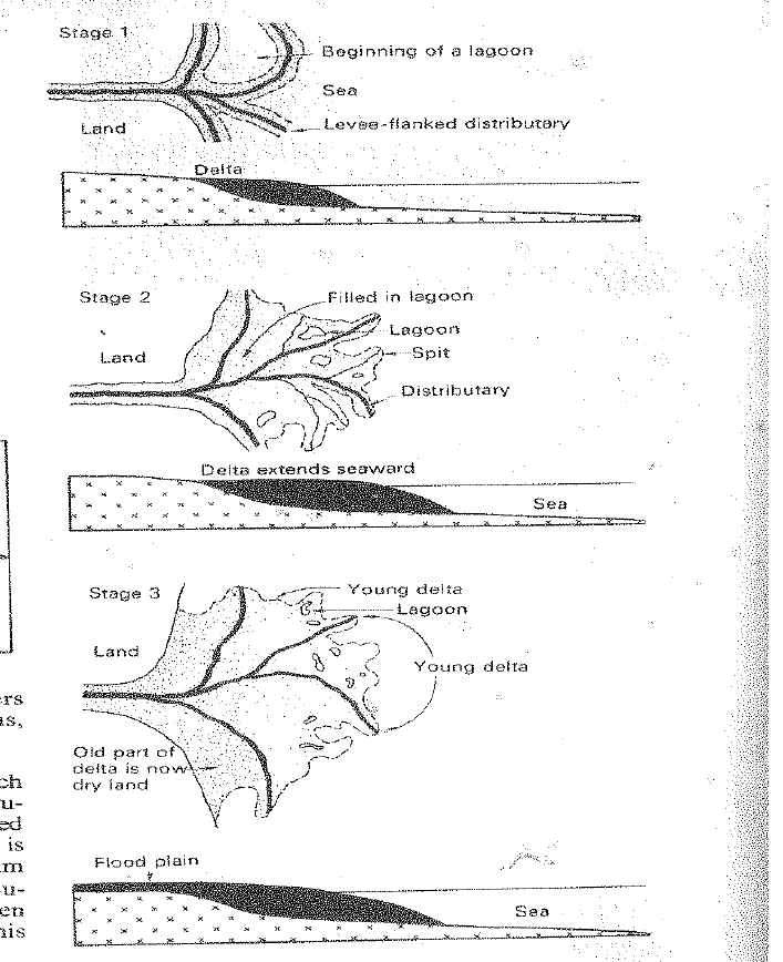
- pg. 154
Older parts of the delta eventually become part of the flood plain.
Diagrams illustrating formation of deltas
TYPES OF DELTAS
1. Arcuate deltas
These are formed of coarse and fine sediments such as gravel and sand. They are triangular
in shape or they have a shape of an inverted cone and many distributeries eg. R.Niger and
Nile deltas.
- pg. 155
2. Estuarine Deltas
These are built by rivers depositing material in a submerged river mouth. Sand banks are
formed with several distributeries winding around them.
They take the shape of an estuary eg R. Congo between Boma and Banana ports before it
reaches the ocean.
3. Bird’s foot digitate deltas
These are formed by rivers carrying very fine materials/silts into the water where wave
energy is too low to remove it.
There are a few long distributeries boarded by levees eg. R. Omo in Ethiopia as it enters
Lake Turkana.
IMPORTANCE OF DELTAS
Deltas provide fertile alluvial soils which can support agriculture eg wet rice growing.
They are good geographical features which attract tourists.
Encourage fishing because they are rich in plunktons.
Deltas provide raw materials for hand craft industry e.g papyrus and clay for the ceramics
industry etc.
Deltas may encourage alluvial mining (placer mining)
In case of estuary deltas, they can be good sites for the construction of ports and harbours.
Promote Study and research.
Disadvantages
They may hinder the development of ports and harbours as well as inland transport because
rivers channels across them are very shallow due to continuous silting.
Deltas often lead to flooding of the land scape adjacent to them. As a result, they may
interfere with settlement, construction of roads and railways and may encourage the spread
of bilharzia and other water born diseases.
Question
(a) Distinguish between deltas and estuaries.
(b) Account for the formation of deltas.
16.9 RIVER CAPTURE.
Is the process where by one river course is diverted into a system of an adjoscent powerful river
which is able to erode into the valley more rapidly than its weaker neighbor.

- pg. 156
When one river becomes more powerful than its neighbor, it will erode backward at a quicker
rate than the weaker river.
Eventually the stronger river will divert the waters of the weak one via the diseroded gap.
Examples of capture include
Tiva capture in Eastern Kenya where lower Tiva captured upper Tiva, a former tributary
of R. Galana, R. Aswa captured captured R.Pager, R. Ruizi captured R.Shaya, R.Wasa
captured R. Nyaboroga in fortportal.
CAUSES OF RIVER CAPTURE
1. Differences in stream power/energy for vertical erosion, where one powerful river and a
less powerful one are flowing adjacent to each other on homogeneous rocks. The more
powerfuls river erodes its bed faster by headward erosion and captures the waters of
another eg R.Nile captured the waters of rivers Tochi, Okole and Arocha in this way.
2. Differences in rock hardness, A river flowing over soft rocks deeply cuts its valley by head
ward erosion into the valley of one flowing over hard rocks, capturing it. River Wasa flowing
on soft rocks captured river Nyaboroga in Fort portal.
3. Earth movements eg uplift and down warp along the course of one river may lead to river
capture. A river flowing over a down warped channel, may extend its valley by headward
erosion and captures the waters of an adjacent weaker river flowing over an uplifted

- pg. 157
channel. Reversed rivers of Rwizi, Katonga, Captured weaker adjacent rivers (streams) when
Western Uganda was uplifted.
4. Influence of river rejuvenation due to changes in sea base level. A rejuvenated river
eroding along a steeper gradient may extend its valley into that of a weaker adjacent river.
5. Gradient/nature of slope where a capturing river/stream is flowing over a steeper slope than
its victim eg. R.Zambezi.
6. Rock jointing, where the capturing river is flowing over well jointed rocks, is able to deepen
its valley, while the captured river is on massive rocks.
7. Volumes of water possesed by the rivers. The capturing river may have more water than
its victim and so will have greater ability to erode than its neighbor/victim. i.e greater head
ward erosion eg the Volta than its victim.
8. A difference in the altitude / base level eg R. Zambezi. This is when two/ more rivers are a
bit near each other but when one has got a higher level of water. Hence it will go on eroding
the soil which separates both rivers. Time will come when it will pull the water of the river
with the lower base level.
Diagram
River 2 erodes the shaded part to pull the water of 2.1 hence capturing it.
LAND FORM FEATURES FORMED DUE TO RIVER CAPTURE
2. Elbow of capture
This is a marked bend formed at a point where the head waters of the captured stream flow
into the capturing tributary. It is a right angled bend.
3. Wind gap
This is a dry valley of the beheaded stream below the point of capture. The floor of this valley
is normally lined with alluvial deposits or gravel.
4. Misfit
This is the valley of the beheaded stream which having lost its head waters, will be reduced
in volume, causing it to appear too small for its valley.
5. Incised valley / Gorge
- pg. 158
Under cutting of the pirate river near the point of capture due to increased water volume
produces a steep and deep valley / rejuvenated valley / Gorge.
6. Formation of knick points
This is a sharp break in the slope created near the point of capture due to rejuvenation.
Water flows down steeply on this knick point resulting into a water fall.
7. Pirate river / stream
This is a river, through headward erosion, that captures waters of another nearby river.
8. Over fit stream / river
Is the river that appears too big for its present valley due to increased volume of water from
the captured river/ stream.
16.10 RIVER REJUVINATION
Refers to the renewed erosive activity in a river valley. It is a situation where vertical and lateral
erosion are increased and a river’s ability to carry its load is increased and at the same time the
spread of the river flow is increased.
CAUSES OF RIVER REJUVINATION
1. Climatic changes ie increased rainfall which increases the water discharge in a river valley
which increases the river energy. This automatically leads to renewal of the river’s erosive
capacity.
2. River capture. This adds more water in the pirate stream /river which increases its erosive
capacity due to the increased speed and volume of water eg lower Tiva captured upper Tiva
river in Kenya.
3. Negative movement of the sea ie where there is a fall in the sea base level, this steepens a
rivers gradient, forcing it to flow very fast, causing renewed erosion. In this case, a river is
rejuvenated.
4. Earth movement also cause river rejuvination. An uplift or upwarping along a river’s course,
leads to steepened river gradient. This leads to fast movement of water, hence increased
erosion.
5. Changes in the nature of the basement rock is also responsible for rejuvination. When a river
which was originally flowing over a hard resistant rock, approaches a soft rock, its erosive
power is renewed. It erodes away much of the soft rock, thus, deepening and widening it’s
channel.
6. An increase in water discharge which increases the rivers volume, speed and erosive
capacity. This may be due to; melting of lce caps and tributaries joining the main river.
- pg. 159
7. Decrease in the load of a river. As it enters a swamp, it deposits the load there. After there, its
speed is increased and it renews its erosive capacity / rejuvinated.
8. Existence of obstacles in a river’s course. After it passes the obstacles, it is rejuvinated.
9. Human activities like damming / construction of dams across rivers, holds back water in the
reservoir behind, but at the same time, when the water is released in the turbines,it flows out
with a high speed. Thus rejuvenating the river’s erosive power. Thus dams along river Nile
from Jinja to Egypt, cause its rejuvination.
EFFECTS OF REJUVINATION ON THE LAND SCAPE
1. Formation of paired river terraces.
These are step or bench like structures cut in the side of a river valley and covered with
gravels and alluvial deposits.
They are formed when a river renews its erosive capacity / down cutting leading to a fall in
the base level.
The parts of the flood plain are not removed after rejuvination. They remain on the valley
sides as illustrated below.
Examples include Birim valley near Kibi in Ghana, along river Ngaila and Nyando in Kenya,
Mpanga, Rwizi, Kafu rivers.
2. Formation of knick points
A kinck point is a sharp break in the long profile of a river valley. It marks the point where
rejuvination started.
A knick point may result from increase in discharge of a river due to river capture.
They are associated with water falls. Eg Charlot knick point on R. Orugu in Sierra Leon and
Burthurst knick point on R. Congo and Mt. Mwachi in Kenya.
Knick points diagrams

- pg. 160
3. Formation of incised meanders
An incised meander is a curved bend of a river that has been under cut / incised into the land
surface so that now a river winds between steep valley walls.
Incised meanders result from rejuvination of an already meandering river eg R.Mwachi in
Kenya. Types of incised meanders are ingrown and intrenched incised meanders.
Note
Refer to meanders notes for diagrams and formation.
4. Valley within valley
A long river where rejuvination was fairly rapid and a fall in base level quite large, the effect
is the production of a steep-sided rejuvinated gorge.
Examples are along R. Mpanga near Arubaho in Fortportal, R. Semuliki and R. Nyando.
- pg. 161
DRAINAGE PATTERNS
Drainage pattern refers to the physical lay out of a river and its tributaries on the earth’s surface.
The main types of drainage patterns in East Africa are controlled by;-
Slope of the land scape.
Differences in rock hardness over which the river may be flowing.
Structure of the rock as it may be determined by different geomorphic processes.
Climatic factors and earth movements.
There are two bread groups of drainage patterns namely; accordant and discordant drainage
patterns.
Accordant drainage pattern is the one where the drainage is related to the structure of the
rock eg dendritic, trellis, annular etc
While discordant is the drainage pattern which does not show any relationship between the
river system and the structure of the rock and relief eg super-imposed drainage pattern.
The distinctive drainage patterns in East Africa include;
ACCORDANT DRAINAGE PATTERNS
Dendritic drainage pattern
Is the one whose structure is shaped like a tree trunk and the branches of the tree or the
structure of a leaf and its veins.
The tributaries converge on the main stream from many directions at a cute angles eg
rivers Panagani, Rufigi, Ruizi, Tana, Victoria Nile, Malagalasi, Ruvuma, Nyando, Nzoia etc.
CONDITIONS FOR THE DEVELOPMENT OF DENDRITIC DRAINAGE PATTERN
It develops in a region which is made of homogeneous crystalline (igneous) rocks which offer
the same resistance to erosion and which have a uniform structure.

- pg. 162
It develops on gently dipping / sloping land scape and this determines the direction of the
river and its tributaries.
Each tributary flows in a valley proportional to its size or volume of water and maintains its
flow.
It develops in regions which receive heavy rainfall which is reliable. That is why it is most
prominent in the equatorial / tropical regions where there is heavy and reliable rain fall to
support the multiple tributaries.
It develops in a common large catchment area. The multiple tributaries cover at a large
catchment area.
Diagram
Radial drainage pattern
This one develops on a dome on volcanic cone. The rivers flow outwards forming a pattern
like the spokes of a wheel eg Mt. Elgon with rivers like Siroko, Siti, Koitobosi, Mara, Manafa,
Nzoia and Mountains Meru and Kilimanjaro areas where the tributaries of R. Tsavo and Ruvu
form a radial pattern and on Mt. Rwenzori where rivers Mobuku, Nyamugasani,
Nyamwamba, Mugusu, Lume, Ruanoli,Sebwe etc originate.
CONDITIONS WHICH FAVOUR DEVELOPMENT OF RADIAL DRAINAGE PATTERN
Presence of a dome or cone shaped highlands such as a volcanic cone / mountain or
highlands which provide the source of the rivers.
Presence of steep slopes which accelerates down ward movement and erosion of the rocks to
create channels along which rivers flow.
It develops in areas of homogeneous and crystalline (igneous) rocks which offer the same
resistance to erosion. This enables the rivers to erode on any side of the mountain. Thus the
development of a radial pattern.

- pg. 163
High precipitation in the catchment area inform of rain fall, snow or the melting of glaciers
which provide a continuous supply of water needed for the development of rivers.
Diagram
CENTRIPETAL DRAINAGE PATTERN
This is a pattern characterized by a large number of rivers from different directions converging
onto a common point. It is commonly formed in areas of in land drainage eg around L.Victoria
where rivers Katonga, Kagera, Nzoia and Sio flow and L.Baringo where rivers like Loboit, Ol
mukutani, Ol Arabel and Malo converage.
CONDITIONS FOR ITS DEVELOPMENT
Basin landscape on valley which could be formed by warping like the case of L.Victoria or
faulting line in the case of L. Baringo. Such basins accelerate or steepen the gradient of the
adjacent rivers which then undertake head-ward erosion towards a common point.
Heavy rain falls to support the multiple rivers flowing towards the common point.
- pg. 164
Develops in regions which offer equal resistance to erosion. Generally soft rocks favour the
development of the river through head ward erosion.
TRELLIS DRAINAGE PATTERN
It develops in areas made up alternating belts of hard and soft rocks which all dip in the same
direction and which lie at right angles to the general slope down which the principal
(consequent) river flows.
The tributaries (subsequent) extend their valleys by head ward erosion into the weak rocks
which are turned into wide valleys called vales and the hard rocks stand up as escarpments.
Trellis pattern also occurs in areas that have been affected by faulting eg R. Kerio in Kenya and R.
Mayanja with tributaries Kato, Wasswa, R. Aworanga, Pager, Aswa, Tiva and Galano.
Diagram
CONDITIONS FOR THE FORMATION OF TRELLIS DRAINAGE PATTERN
Develops in areas of heterogeneous rocks ie areas with both soft and hard rocks.
It develops also in areas of jointed rocks due to faulting.
Heavy and reliable rainfall to support development of consequent and subsequent rivers
which constitute the drainage pattern.
Cover a large catchment area with reliable rainfall since the streams are widely spaced.

- pg. 165
May also develop due to river capture eg along river Tiva, Galana, Aswa, Tochi, pager etc.
RECTANGULAR DRAINAGE PATTERN
This is a pattern which displays a rectangular shape with tributaries joining the main stream at
approximately right angles (90
0
) eg R. Mayanja- Kato, Wasswa.
It develops in areas which have been affected by earth movements and where the faults intersect
each other almost at right angles.
Streams may develop along such faults and such streams will therefore be fault guided and all
will acquire a rectangular pattern eg R.Aswa, Tochi, Awovanga and pager.
CONDITIONS FOR ITS DEVELOPMENT
Areas must be receiving ample reliable rainfall to maintain the flow of streams to complete
the patterns.
Structural control with streams following joints or fault lines in the rocks ie faulting
influences rectangular drainage pattern development.
Diagram
ANNULAR DRAINAGE PATTERN
Is a pattern where tributaries join the main stream at sharp angles but in a series of curves.
It develops in volcanic regions where rivers flow sharply in a series of curves around craters
or calderas eg around Ngorongoro caldera.
Diagram

- pg. 166
CONDITIONS FOR ITS DEVELOPMENT
It develops on a dissected dome / upland with alternating hard and soft rock which favours
its development where streams erode valleys in less resistant strata.
Presence of heavy rainfall to supply water to the flowing streams.
Rivers must flow in a series of concentric curves conforming to the weaker rock out crops
and flow outwards eg around L. Bosumutwi in Ghana where rivers Banko and Buonim flow
in concentric curves.
PARALLEL DRAINAGE PATTERN
This is a pattern where streams and their tributaries flow parallel to one another side by side
down slopes eg rivers on Mt. Rwenzori, R. Nkusi and R. Hoima flow parallel to each other on
Butiaba escarpment before joining L. Albert, and west of Mau ranges, where tributaries of river
Athi such as R. Nairobi, Thirika, Komu and Ruiru flow parallel to each other and rivers flowing
from Mt. Muhavula.
CONDITIONS FOR ITS DEVELOPMENT
Develops in areas of alternating bands of soft and hard rocks. Soft rocks are eroded to form
the river channel while the hard rocks resist erosion to form a divide which limit chances of
adjacent rivers joining each other.
Rivers flow in the same direction each forming its channel through hardward erosion of the
soft rocks.
Pronounced divides made up hard resistant rocks between the rivers limits the chances that
the rivers could join each other.
It also develops in faulted regions in that rivers tend to flow by eroding through the lines of
weakness (fault lines) created by earth movements.

- pg. 167
Reliable rainfall and a large catchment basin important to sustain the existence of the river.
Diagram
BARBED OR HOOKED DRAINAGE PATTERN
Is the one where tributaries of a river join the main stream at angles contrary to the original flow
of tributaries ie at acute angles.
It develops on rivers whose direction of flow has been reversed due to warping on one side and
uplifting on the other eg R.Rwizi, Kagera, Kafu, Katonga all of which are reversed rivers.
Diagram
CONDITIONS FOR ITS DEVELOPMENT
Existence of alternating dips of slope. The rivers joining the main rivers originated from a
higher point opposite to the source of the main river. After the change in gradient as a result
of the uplift in the direction of the main river, the joining rivers reverse to join the main river
because they fail to climb or erode through the steep gradient created ahead of them.
River capture where a strong river diverts the waters of a weaker stream into its system.
- pg. 168
A big catchment area and reliable rainfall.
BRAIDED DRAINAGE PATTERN
This is found or formed in flood plains of a river where the energy of the river to transport
sediments is considerably reduced and the river is forced to drop some of its lead along its
channel / course dividing itself into several channels eg the lower parts of the Nile, Kilombero,
Rufigi, Mkomanzi.
CONDITIONS FOR ITS DEVELOPMENT
Reduced energy of the river to transport sediments.
Reduced gradient.
High competence of the river to erode in the upper and muddle course of the river. Hence
carrying a large load.
9.3 Discordant /obsequent drainage pattern
Super imposed drainage pattern
Is the one where rocks on which the river was initially flowing has been worn away and the
river is now flowing over older and different land scapes to which the river is not adjusted or
related.
If the drainage pattern from above is maintained and is not affected by the structures of the
current exposed older rocks, then, it is super imposed eg R. Zambezi was super imposed on
the Karro rock sediments R. Nile at Sabaloko in Sudan.
Conditions for its development
It develops where there is no direct relationship between the river and the rocks upon which
the pattern is flowing.
When the drainage pattern / river is energetic enough to erode or under cut far deeper and
reach new rock structures.
When the river is able to maintain its drainage pattern, original course and direction on the
new rock structure.
When the original rock onto which the river originally developed were soft and therefore,
highly eroded through down cutting / incision to reach the new set of rocks down wards.
Diagrams

- pg. 169
2. Antecedent drainage pattern.
Is another type of discordant type /pattern. They are common in areas where uplifting took
place slowly enough for the river to maintain its down cutting and where there has been
insufficient time for the drainage to become completely adjusted to the structure.
Their formation involves an uplift of land within the river course. As the uplift occurs, the
river maintains its course by down cutting at a rate balanced by the rate of uplift.
Therefore, the rate of uplift should be slow enough to allow a river to maintain its course
through vertical erosion.
Thus creating a deep gorge within the uplifted region eg along R. Ruaha in the irringa
highlands of Tanzania and the Lukuga river which flows into the Zaire basin.
Diagrams

- pg. 170
LAKES IN EAST AFRICA.
A lake is a basin or hollow more or less extensive on the earth’s surface which contains water.
Some lakes are shallow ,others are deep.
Some are salty, others are fresh.
Some are extensive, others are narrow.
Some are regular, others are irregular
Lakes can be classified according to their mode of formation. The major categories include;
- Lakes produced by earth movements.
- Lakes produced by volcanicity.
- Lakes produced by erosion.
- Lakes produced by deposition.
- Lakes produced by man.
LAKES PRODUCED BY EARTH MOVEMENT
(a) FAULTING
(i) Graben lakes /rift valley lakes
These are lakes which occur on the floor of the rift valley. They are characterized by an
elongated outline, steep sides ,great depth, salty and narrow and generally take the shape of
the rift valley.
They are formed as a result of secondary faulting that takes place on the rift valley floor thus
creating minor depressions which are filled with water from the rains or rivers which
collects there to form graben lakes eg L. Albert fed by R.Semiliki and Nile, L.Turkana fed
by R.Omo and several streams from Mt. Elgon, L.Edward fed by several rivers
egRuiziRutshiruruNyangarami and Ishasha
2. Tilt block lakes
These are angular lakes which occur intilted regions and occupy the depressions which are
formed in the titled regions.

- pg. 171
They are formed during tilting when some blocks were raised to form ridges while others
lowered to form depression. Water collected in the depressions to form tilt blocks
egL.Olbolossat in Kenya.
3. Warping formed depression lakes or down warped or crustal basin lakes
Down warping of the central plateau surface created basins/ depression. Where as the
upwarping / uplifting in Western Uganda forced rivers like Kagera, Katonga, Kafu back pond
or reverse their flow and thus poured their water in the newly created Victoria and Kyoga
depressions to create L. Victoria and L. Kyoga other examples of down waveed lakes are
L.Mburo, L.Wamala, Nakivali and Kijjanebalola.
LAKES PRODUCED BY VULCANICITY
(a) Explosion crater lakes
These are circular wider lakes formed when violent gaseous explosions remove the over
lying crystalline rocks to form wider circular depressions that are filled with water from

- pg. 172
rainfall, internal springs and rivers eg L. Katwe, Kasenyi, Nyuungu, Kikorongo, Rutoto,
Munyanyange, Nyamunuka.
(b) Crater lakes
These are lakes which are formed on summits of dormant volcanoes or extinct volcanoes
egcrater on Mt. Muhawala, Mt. Kenya Qisozi in Kisoro in BushenyiLongonot crater
on Mt. Longonot.
They are formed when a violent eruption blows off the mountain top leaving behind a
tunnel shaped depression. This was filled with rain water to form a crater lakes.
(c) Caldera lakes
These are formed as a result of a very violet eruption that blows off a large top of a
volcano leaving behind a huge wider and circular depression OR the depression is due to
cauldron subsidence ie when the volcano summit subsides downwards leaving up a wide
circular depression where rain water collects to form a caldera lake
egNgorongoroLongonot, L. NgoziLmbagai etc.

- pg. 173
(d) Lava dammed lakes
Are lakes formed when basic lava blocks a river valley causing back ponding behind the
lava dam eg Lakes Bunyonyi, MutandamuleheChahafi, Kayumbu, L.Saaka in
Nyakasura formed as a result of damming of river Liso.
EROSIONAL LAKES
Glacial erosion through plucking, abrasion and ice wedging creates hollows which when are
filled with water , form lakes eg;
(i) Cirque / Tarn lakes
These are lakes that form in the arm chair like depressions formed as a result of nivation
plucking abrasion etc by glaciers of a pre-existing hollow on a mountain forming cirques.
When filled with melt water and rain water Tarn lakes are formed egLac Du Speke, Lac
Noir and Lac Catherine on Mt. RwenzoriTeleki tarn on Mt. Kenya.

- pg. 174
(ii) Trough lakes / Ribbon lakes
These are lakes also formed by glaciation.
They are formed in elongated hollows excavated in U-shaped valleys by glaciers through
plucking, abrasion and frost shutteringegBujuku trough on Mt. Rwenzori and
Mickaeelson on Mt. Kenya. These depressions are filled with glacial melt waters and rain
waters to form ribbon or trough lakes.
(i) Rock basin lakes;
These are formed by ice scouring action resulting in hollows, that are easily eroded
especially in zones of soft rock belts or where the valley becomes narrow eg Lac Vert on
the floor of Kamusoso valley on Mt. Rwenzori, L.Carr and Michaelson on Mt. Kenya.
SOLUTION LAKES
These are lakes formed in limestone areas like Nyakasura and some parts of Tororo. Rain water
combines with carbondioxide to form a weak solution of carbonic acid which dissolves the
limestone and later removed away in a solution form, leaving behind pits / hallows which are
then filled with rain water to form solution lakes.
LAND SLIDES / MASS WASTING LAKES
These are formed when rock waste / debris slide downwards, blocking a river valley to form a
lake egL.Bujuku, LMbaka, L.Nyabihoko in Western Uganda etc.
MAN MADE LAKES
These are formed as a result of mining egL.Kajjansi river damming eg lake Kindaruma,
excavation egKabaka’s lake, Omugabe’s lake in Mbarara, valley dams fish ponds etc.

- pg. 175
DEPOSITIONAL LAKES
(a) Glacial deposition;
(i) Moraine dammed lakes.
These are formed when terminal moraines block a river valley eg Lac Gris on Mt.Rwenzori,
L. Honel and Hut Tarn on Mt. Kenya.
(ii) Kettle lakes
These are formed when a mass of ice enclosed in a terminal moraine melts away, creating a
depression on top of a terminal moraine egMahoma on Mt. Rwenzori.
(b) Wave deposition;
(i) Coastal lagoons (haffs)
These are formed as a result of deposition of material by the long shore drift of waves. Spits
and spurs are formed enclosing a bay or part of the lake or sea water. This is what is called a
coastal lagoon lake egNabugabo and Tonya point on L.Albert.
(ii) Coral deposition forms lagoon lakes at the East African Coast.

- pg. 176
RIVER DEPOSITION causes;
(i) Ox-bow lakes
These are formed by river deposition in flood plains.
It is formed when there is an acute meander whose concave banks have been greatly cut into
and the eroded materials deposited on the convex bank of the meander. The narrow neck which
was separating the two bends of the meander are ultimately cut into.
The deposits seal up the old cut off the meander to form an ox-bow lake eg on R. Tana, Nyando,
Semuliki, Ruizi, Ngaila, Nzoia.
(ii) Delta
These form in delta flood plains when alluvial deposits form levees that stop water in the flood
plains from joining the river and its tributaries eg. L. Magomeni, L.Mwanyamara in Tanzania,
L.Mchengu on R. Rufigi ,etc.
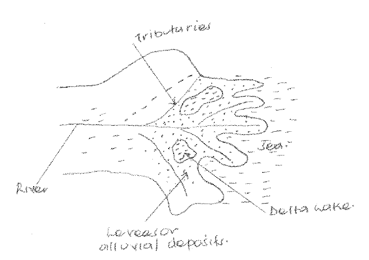
- pg. 177
IMPORTANCE OF LAKES
- Sources of water for domestic and industrial purposes eg L. Victoria is a source of water to
Kampala, Kisumu, Musoma, Mwanza and Jinja.
- They provide water for irrigation eg L. Kyoga support olwenyi scheme, L.Kibimba supports
kibimba rice scheme.
- They promote mining eg salt in L. Katwe, soda ash in L. magadi. This has promoted
industrialization.
- Fishing.
- Clay along the shores of lakes eg Victoria is extracted to make bricks and tiles at Kajjansi and
Kisumu hence promoting industrialization.
- Papyrus vegetation at the shores of lakes eg Victoria, Kyoga etc facilitate the art and craft
industry.
- L. Victoria is a reserviour of water for harvesting hydroelectric power at Nalubaale and kiira
dams.
- Big lakes such as Victoria and Kyoga help in the modification of the climate by recharging it.
Hence leading to heavy convectional rainfall in adjacent areas like Mukono, Jinja, Kisumu etc.
this promotes agriculture.
- Sand used for construction is obtained from the sand beaches like Kasenyi, Lutembeetc along
the shores of L. Victoria.
- pg. 178
- They promote tourism eg the beaches, landing sites, game fishing along L. Victoria and
Tanganyika.
- They help in regulating the flow of rivers and therefore control flooding.
NEGATIVE IMPORTANCE
- Flooding which disrupts economic activities like agriculture, fishing villages like Wanseko,
Ntoroko and Buhika on L.Albert, Lwampanga, Kazwamaetc on L.Kyoga.
- Lakes limit the development of transport routes in the surrounding areas due to soft and
boggy nature of the land scape and the flooding.
- Lacustrine wetlands near lakes egKachindo and Babupatel wetlands around L. Victoria are
breeding grounds for mosquitoes and other vectors which transmit diseases.
- Crocodiles from Lake George, Kyoga and Victoria are another problem caused by lakes. Such
predators limit settlement and farming near lakes.
- Drowning in lakes such as Victoria and Albert due to waves and strong winds leads to loss of
lives.
- Lakes cover considerable masses of land which would be used for some other economic
activiti
- pg. 179
SECTION C
SOILS IN EAST AFRICA
Soil is a natural body (thin layer on the earth’s crust) made up of weathered rock particles,
decayed plants, animal tissues, air, water, humus e.t.c. that exists on the earth’s crust.
OR
Soil is a natural body made up of weathered materials, decayed plants rock minerals, humus on
the earth’s surface that supports plant growth.
Soil is majorly composed of the following air, water, humus, weathered rock fragments, decayed
plant material, living organisms, and animal tissues e.t.c.
There are various types of soils e.g.
A zonal soils zonal soils, intra zonal soils and lateritic soils
The classes of soil in East Africa include:
Clay soil, loam soil sandy soils
PROCESSES OF SOIL FORMATION IN EAST AFRICA
Processes refer to the activities which operate on the parent rock materials and decayed matter
to produce soil.
1. QN Explain the activities responsible for soil information in East Africa
2. Examine the soil formation processes in East Africa
1. Weathering
This involves the breaking down, fracturing disintegration and decomposition of large rock
particles to form smaller rock particles (soil)
Weathering is either physical or chemical depending on the relevant factors. It is the major
soil forming process and it leads to the formation of mature soils (mature soil profile)
- pg. 180
2. Leaching
Leaching refers to the vertical movement of soil nutrients from the upper layer of the soil
profile to the lower layers of the soil profile in a solution or suspension form. It involves the
removal of soluble nutrients from the upper layers to the underlying layers by running
water.
The nutrients include salts, carbonates and other mineral elements.
Leaching deprives horizon A of the soil profile with all mineral nutrients and enriches
horizon B of the soil profile
3. Elluviation
This refers to both the vertical movement and lateral movement of soil nutrients from the
upper layers of the soil profile to the lower layers in a solution or suspension form. It refers
to the movement of soil material materials in a solution form or suspension form from one
place to another within the soil. It may be vertical or horizontal (lateral) depending on the
direction of the movement of water.
4. Illuviation
This is the process of soil formation that results from elluviation and leaching. It also refers
to the participation and accumulation of both the leached and elluviated materials in the
horizon B of the soil profile are known as the accumulation zones (Illuviation zones). This
also deprives horizon A and enriches horizon B
5. Humification
This refers to the process of soil formation through which organic matter is decomposed and
decayed and later turned into humus. It is common in wet and warm areas which are densely
vegetated especially the equatorial regions which receive heavy rainfall and hot
temperatures. These speed up the chemical reactions thus decomposing material into
humus.
This process leads to the formation of rich fertile and well developed soil profile (mature soil,
Horizon A)
6. Mineralization
This is a process of soil formation where extreme decomposition takes place under extreme
warm and wet conditions. Therefore the decomposition of organic matter exceeds
humification i.e. organic matter is broken further into other inorganic substances such as
carbon dioxide, Silica etc. and this mainly occurs in the upper layers of the soil profile
(Horizon A) hence enriching it with developed soil profile.
- pg. 181
7. Calcification
This involves the upward movement of dissolved calcium components from the lower layers
of the soil profile to the upper layers through capillary action. It takes place mainly in humid
areas where capillary action is high and evaporation is very high. The hot temperatures
cause underground water to rise upwards gradually towards the earth’s surface where it
eventually evaporates leaving behind previously dissolved calcium and this leads to the
formation of soils reach in calcium content (mature soils or pedacols)
8. Podsolization
This process prevails in cool humid temperate regions especially in areas with coniferous
vegetation. This process involves leaching, Elluviation, and humification leading to the
formation of pod soils.
Humification is very important here because it results into acidic conditions which hence
intensifying other soil forming process in such regions. This results into the formation of
acidic soils as a result of further decomposition of organic matter.
Podsolization results into the formation of best developed soil profiles in the different A and
B horizon of the soil profile.
9. Salinization
This process involves the formation and accumulation of a thin layer of salts to the surface of
the earth. It involves acidic range of accumulation of soluble mineral salts on the surface of
the earth as a result of excessive evaporation and capillary action. This takes place after
other soil forming processes have occurred i.e.elluviation, and humification.
10. Lateralization
This is a process which involves the formation of lateritic soils.
The formation is due to the excessive rainfall and temperatures which bring up intensive
weathering of rocks.
After weathering silica from rocks is removed by water and transferred from Horizon A to
Horizon B of the soil profile. Through the process of elluviation.
Due to the hot conditions, iron and aluminum compounds are moved from Horizon A to
horizon B through elluviation and illuviation when temperatures continue rising iron and
aluminum are carried to the earth’s surface (Horizon A) through the process of capillary
action accumulating to form a layer on the earth’s crust known as duricrusts which is
weathered down to form lateritic soils/ latosols.
11. Gleization
This process leads to the formation of frozen soils in temperate soils while in the tropical
regions it leads to the formation of peat soils (Boggy soils) they are premature soils due to
poor climate and poor drainage. These two factors don’t allow decomposition in poorly
- pg. 182
drained areas since they limit the reaction of micro living organisms such as bacteria. The
process leads to formation of immature soil profile common in wetland areas.
Qns: 1. Examine the soil forming processes
Approach
Define soil
Give its components and types in a paragraph
Discuss the processes.
1. Examine the processes responsible for the development of soil profiles in East
Africa.
FACTORS INFLUENCING SOIL FORMATION IN EAST AFRICA.
1. Nature of the parent rock.
This refers to the rock texture, rock structure and its mineral elements. Rocks differ in many
ways and therefore influence soil formation in different ways as discussed below.
a Rock resistance (hardness and softness)
Soft rocks e/g/ limestone rocks are weathered down easily and this accelerates the rate of
weathering leading to the development of deep nature of soils whereas hard resistant rock
such as granite limit the rate of weathering resulting into the formation of thin skeletal soils.
b Age of the rock.
Rocks of recent formation do not easily weather down into well-developed soils because they
have not been exposed to soil formation processes such as weathering whereas old rocks
weather down into well-developedmature of soils because they have been exposed to soil
forming processes such as weathering for long period of time.
c Rock jointedness
Well jointed rocks allow easy penetration and percolationof water and gases hence
accelerating a rate of weathering to form deep fertile mature soil whereas unjointed rocks
cannot easily weather down thus forming immature soils
d Rock permeability
Permeable rocks allow water to percolate through them easily hence accelerating chemical
weathering to form deep mature soils whereas impermeable rocks do not allow water to
percolate through them hence lowering the rate of chemical weathering to produce thin
immature and skeletal soils
e Rock colour
Dark colored rocks attract sun’s rise and absorb heat very fast hence accelerating physical
weathering processes to form mature and fertile soils whereas light colored rocks e.g.
- pg. 183
calcium carbonate reflect sun’s rise and do not absorb heat very fast hence limiting physical
weathering and forming immature skeletal soils.
f Mineralogical composition of the rock
This has a great influence on soil formation i.e. the material or elements of the soil may be
derived from the rock i.e. the minerals in the soil consist the minerals in the rock.
Rocks determine the nature and fertility of the soil. Rocks of volcanic origin weather down
into fertile soils which are deep and mature. Quartz which is hard is resistant to chemical
weathering and this forms poorly developed soils. Limestone which is very soft and porous
undergoes chemical weathering thus forming mature soils rich in calcium.
2. Climate
It influences soil formation through its elements i.e. Temperatures, rain fall. Its influence lies in
its control of the rate and nature of weathering
a Equatorial climatic conditions
Hot temperatures and heavy rain fall accelerate chemical weathering and physical
weathering processes resulting into formation of deep mature soils e.g. in Uganda around the
shores of Lake Victoria and areas within the equatorial region
b Tropical climate conditions
Alternate and dry conditions lead to formation of lateritic soils through the process of
leaching. During the dry season, physical weathering occurs leading to formation of
maturesoils through leaching. In wet seasons, intensive chemical weathering processes occur
to decompose the existing rocks.
c Temperate regions
The cool temperatures and low rainfall amounts in the temperate and Polar Regions result
into less soil intensity of weathering and as a result soil forming processes are very low in
such areas and have thin soils (skeletal soils)
d Arid and semi-arid areas
The hot temperatures above 30oC and absence of rainfall in desert and semi-arid areas like
the chalabi desert in Northern Kenya tend to slow down the process of soil formation. This
leads to formation of the poor red desert soils, poor thin sandy soil due to increased
evaporation and limited leaching. This increases the high salt content. The hot and dry
conditions also result into high capillary action resulting into the formation of alkaline soils
which are shallow, poor with undeveloped soil profile.
NB climate influences soil formation in the following ways
Rain fall. It influences the rate of gradual breakdown of rocks into increasing and small
particles until soil is formed. Also as it rains some rain water dissolves CO2 from the
atmosphere to form a weak carbonic acid
- pg. 184
When rain water containing carbonic acids percolate through the rocks containing calcium
carbonate the rock decomposes and dissolves to form smaller particles finally forming
maturesoil.
The hot temperatures and heavy rainfall also increase the rate of decay and decomposition of
large quantities of trees and animal remains.
Temperature also influence the growth of bacteria which later decomposes the dead
materials to form humus. Climate also influences vegetation growth indirectly which is an
important element of soil forming processes through provision of inorganic and
undecomposed matter. In areas where rainfall is with a great intensity, it heats up the rocks
especially when the ground is left bare removing and tearing off some of the particles and
chemically decomposes rocks (in well jointed rocks). This leads to the formation of mature
soil.
3. Vegetation
The nature of vegetation influences soil formation in the following.
Tropical forests produce a lot of humus derived from decay of leaves and trees. It also
determines the amount of water which is detained in the atmosphere and underground
which also determines the rate of chemical weathering and humification high to form mature
soil..
Vegetation helps to protect soils from erosion and deep mature soils are formed because the
weathered materials are not washed away whereas the soils in scanty vegetation are eroded
resulting into formation of thin skeletal soils.
Plants or vegetation roots also lead to the disintegration of rocks and formation of mature
soils due to chemical decomposition.
.Forested areas therefore tend to have deeper soils in well developed areas while areas
which thin vegetation cover have thin skeletal soils and poorly developed profiles.
4. Living organisms.
The influence of animals on soil formation is largely mechanical. Earth worms, termites all
these contribute to soil formation asit passes through and make passages through the
rockhence aiding weathering and breaking downrocks leading to the formation of deep soils.
Burrowing animals like Rabbits, Squirrels, chain up rock fragments thus improving aeration
and drainage which promotes weathering and soil formation.
Man influences soil formation through agricultural practices by weathering and breaking up
the soil and rock particlese.g. road construction, adding fertilizers to the soils to form mature
soils.
- pg. 185
5. Topography / Relief.
The nature of slopes will influence soil formation from deep fertile/ thin soils. On the steep
slopes erosion is more rapid than on the gentle slopes. This facilitates the washing away of
weathered materials consequently steep slopes develop thin or skeletal soils.
On the gentle slopes erosion to lowered. There to a lot of decomposition of soils eroded from
the steep slopes and rain water percolates to assist in chemical weathering and soil
formation processes hence forming deep mature soils.
Valleys or low lands are characterized by extensive decomposition and percolation of water
hence deep weathering, lateralization and Gleization.Which leads to the formation of deep
mature soils. Where there are waterlogged conditions there is formation of immature soils.
6. Time,
Soil forming process is very slow and long. Ample time is therefore needed to lead to the
formation of mature fertile and deep soils. If the time is short immature or a zonal soils will
be formed with poor developed soil profiles e.g. the soils of Nyamulangira are still skeletal
because they haven’t been exposed to weathering processes for a long period of time.
Qns (a) To what extent does relief / topography influence soil formation in East Africa.
(b) Examine the factors influencing soil profile development in East Africa.

- pg. 186
SOIL PROFILE
This refers to the vertical arrangement of soils from the earth’s top surface to the bottom
(parent rocks) it is composed of soil layers called horizons which are differentiated in terms
of depth, textures mineralogical composition and structure.
Soil profile differs from one place to another however an ideal profile is composed of Horizon
A and B as shown below.
Top soil A oo – under composed litter(Humification)
Ao – Decomposed organic matter.
A
1
– High humus content
A
2
– maximum leaching
A
3
– Transitional zone
B
1
– Transitional zone
B
2
– Maximum deposition
B
3
– Transitional zone
- Partially weathered rocks
Unweathered / solid parent rock
Horizon A (TOP SOIL)
It is the top most layer sometimes defined as the topsoil. The top designed as A0 which consist of
undecomposed litter (humification). It is followed by A00 which is decomposing organic matter
and A1 which has humus content and which gives this horizon its dark colour. It is followed by
A2 which is poor in nutrients because of leaching and elluviation which makes it light coloured
or bleached. It is followed by the transitional zone.
HORIZON B (SUB SOIL)
It is the next layer below A and is the zone where nutrients and materials are removed from
Horizon A accumulating in the process of elluviation and illuviation. It is therefore ever rich in
nutrients.
HORIZON C
It is consists of recently and partially weathered parent rock materials (regolith on the bed
rock).
HORIZON D
Is the last layer of the soil profile and consists of solid parent rock bed rocks.
B
C
D
D
A
D
Sub soil
- pg. 187
FACTORS THAT INFLUENCE SOIL PROFILE DEVELOPMENT.
(1). Nature of the parent rock
i. Hardness and softness/ rock resistance.
Hard rocks are not easily weathered down hence forming thin skeletal soils and poorly
developed soil profile while soft rocks are easily weathered down to form deep mature
soil profile.
ii. Rock jointedness
Well jointed rocks with cracks are easily broken down or disintegrated to form deep
mature profiles compared to unjointed rocks.
iii. Rock colour
Dark coloured rocks absorb heat easily accelerating physical weathering to form deep
matures soil profiles compared to light coloured rocks which are not easily weathered
down.
iv. Rock P
H
Acidic igneous rocks are hard nature and difficult to weather down. This makes them to
produce shallow immature soil profile and poorly developed soil profiles.
v. Permeability of the rock. (Porous rocks)
These are easily weathered down by chemical weathering processes to produce deep
mature soil profiles as compared to impermeable rocks which may produce shallow soil
profile.
vi. Mineralogical composition of the rock.
Rocks of volcanic origin (acidic and basic rocks) weather down into deep fertile and well
developed soil profiles. Quarts forms hard resistant particles / grains which are resistant
to chemical weathering hence forming soils that are sandy in nature within developed soil
profile.
Ferricates are rich in iron and tend to be dark in nature therefore they are weathered
down to form soils with developed soil profile.
(2). Climate
Climate determines the character and rate of weathering.
In humid areas (hot humid) weathering occurs at a faster rate leading to the formation of
deep soils with a well-developed mature soil profile.
(3). Vegetation
Areas with thick vegetation over shade off a lot of litter which decays and decomposes down
to form humus in horizon A hence a well-developed soil profile.
Plant roots lead to disintegration of rocks and formation of soils which are mature and well
developed. Therefore forested areas tend to have deep soils with mature soil profiles. Areas
with scanty or thin vegetation cover dispose off less litter hence thin skeletal and poorly
developed soil profiles.
- pg. 188
(4). Drainage
Water logged areas do not allow excessive decomposition since the reaction of the micro
living organisms is too low to allow decomposition. This leads to the formation of poorly
developed soil profiles.
Well-developed mature soil profiles since they accelerate most of the soil formation
processes.
(5). Human activities such as mining, road construction etc. these lead to disintegration of
rocks and formation of deep soils characterized by well-developed soil profiles.
(6). Living organisms. E.g. earth worms, mammals, rodents. These breakdown rocks as they
create passages and cracks weathering the rocks down to form deep soils with a mature soil
profile.
(7). Time
Ample time is needed or required to lead to the formation of mature fertile and deep soils
with a well-developed soil profile.
The shorter the time of exposure, the in mature the soils formed. These are always
characterized with a poorly developed shallow soil profile.
(8). Topography / relief
Steep slopes are more susceptible soil formation. This is because of the high water surface
run off resulting into thin shallow and immature soil profiles.
Gentle slopes are characterized by limited soil erosion and a lot of the deposition of the
eroded soil takes place around the gentle slopes, leaching process occur and rainwater
easily percolates to assist the soil profile development. This leads to the development of
deep mature soil profile.
Valleys / low lands,
Valleys / low lands are characterized by extensive deposition. This leads to formation of
deep mature soil profile. However, where there too water logging there is development of
immature soil profiles. Because deposition, decomposition and humification are ineffective
due to low reaction of the micro living organisms.
Qns:
1(a) Define the term soil profile.
(b) Explain the factors responsible for the development of soil profile.
2 (a) Examine the processes responsible for the development of soil sample.
(b) Distinguish between soil catena and soil profile.
(c) Account for development of soil catena in any of the areas in East Africa.
- pg. 189
SOIL CATENA.
IS A HORIZONTAL sequential arrangement of soils on a given slope from a hill top to the
valley bottom?
They are formed under similar climatic condition but characteristics differ with the
variation of the topography and drainage.
Soil catena shows different characteristics in color, depth, texture and the water content in
the soil as a progress from a hill to the valley bottom.
Diagram,
- pg. 190
FACTORS WHICH INFLUENCE THE SOIL CATENA DEVELOPMENT
1. Drainage.
Where drainage is poor e.g. in low lands acidic and readily leached soils are formed.
Gentle and steep slopes are well drained and have a high water holding capacity which leads to
deep soil, dark brown soils with fine texture.
On hill tops a lot of silica is leached leaving iron and aluminum giving the soil a reddish brown
colour.
On hill tops there is excessive leaching and capillary action leaving behind red thin soils after
silica is leached. Iron and aluminum remain giving the soil a reddish brown colour.
Steep slopes accelerate surface run off leading to the development of thin soils that are skeletal
in nature.
Gentle slopes have high water holding capacity leading to deep chemical weathering resulting
into the formation of deep soils, dark brown soils with a fine texture.
In lowlands, there is deposition of materials leading to the formation of alluvial soils with the
effect of water logging. The soils are poorly drained e.g. clay.
2. Climate
Heavy rainfall greatly facilitates leaching of soils especially on hill tops leading to the formation
of iron and aluminum red brown soils which are lateritic in nature.
Heavy rainfall also influences surface run off of the steep slopes leading to the formation of thin
skeletal soils which are stony.
The heavy rains lead to the formation of deep fertile soils on the gentle slopes due to the deep
chemical weathering. Whereas the heavy rainfall leads to water logging in valleys which
facilitates the formation of grey acidic clay soils which are poorly drained.
3. Living organisms like rats, rabbits and squirrels facilitates the formation of deep soils on
gentle slopes and thin skeletal soils on steep slopes thus their activities of making passages
through the rocks or soils on slopes because they facilitate deep water infiltration on gentle
slopes which leads to deep water infiltration on gentle slopes which leads to deep chemical
weathering on gentle slopes forming black fertile soils and movement of weathered materials
along the steep slopes thus forming thin soils.
Limited living organisms in low lands lead to the formation of peat soils clay soils which are poor
in humus.
- pg. 191
Man’s activities like rock blasting, agriculture and mining on steep slopes may lead to the
formation of thin skeletal soils.
Agricultural activities on gentle slopes facilitate water infiltration in the weathered particles
thus facilitating deep chemical weathering hence forming deep fertile black soils.
4. Nature of the parent rock.
The characteristics of hard rocks in terms of hardness, softness, structure, jointedness determine
the rate of erosion and deposition and water infiltration thereby influencing the type of soil to be
formed down slope.
In addition a different soil along the slope could be the results of different parent rock materials.
5. Time
Ample time is required for the formation of a well-developed soil catena.

- pg. 192
TYPES OF SOILS.
Soils have been classified into 3 major types..
1. Zonal
2. Azonal
3. Intrazonal
ZONAL SOILS
These are mature soils with a well-developed soil profile due to prolonged action of climate and
vegetation. i.e. they have been exposed to soil forming processes for a long period of time.
These soil types are largely as a result of climatic factors which contributes to their forming
processes.
They develop as a result of drainage (well drained areas).
The soils develop on gentle slopes and flat land scape.
Zonal soils are divided into 2;
(i) Pedacols with a high calcium content under conditions of low rainfall,
(ii) Pedlfers, which are rich in aluminum and iron. The resultant soil type is closely related
to the nature of weathering that takes place under a given climatic condition.
In low altitude areas, the hot humid conditions give rise to latosols, tropical black soil
In mid latitude climate of humid conditions are associated with the formation of receiving
seasonal rainfall, chirnozerms soils develop e.g. in Canadian prairies
Semi – arid conditions yield chest nuts coloured soils.
High latitude climate lead to the development of acidic brown soils and Tundra soils.
It should be noted that they are further categorized according to the types of climate under
which they develop.
Types of climate & zonal soils formed.
1. Tropical climate ,
a) Tropical black soils. These are soils that develop in the humid tropical regions which have
volcanic rocks. They are/ rich in calcium carbonate (pedacols) and other materials. Such soils
are referred to as the black tropical soils in East Africa.
- pg. 193
b) Lateritic soils. These are formed under the conditions of rapid weathering brought by hot
temperatures and heavy rainfall. They form from any type of rock that is leached. The washing
down of minerals results into the soils being unfit for cultivation.
2. Temperate climate.
a) Temperate brown soils. Theses form in climatic regions with natural vegetation of
deciduous forests. The soils are rich in humus derived from the decayed vegetation.
b) Pod sols. These have a black dark brown to grey colour. They are rich in humus and are
leached so that they can tend to be acidic and infertile.
3. Cold climate – a) Tundra soils. Theses soils form under conditions of tundra, have a shallow
surface layer of peat where vegetation doesn’t decay completely.
Deep soils can’t develop under the conditions of tundra where the soils are permanently limited
to both chemical and biological weathering.
4. Desert and arid climate – a) Red desert soils. Because of lack of moisture soil forming
processes are very slow in deserts.
The soils formed tend to be thin, stony and sandy, yellowish red to reddish brown with no
humus.
Lack of vegetation cover results into significant organic content therefore desert soils lack the
basic requirements for agriculture like moisture and nutrients
- pg. 194
INTRA ZONAL SOILS
Intrazonal soils.
These soils are classified according to the great influence of relief and the parent rock. The soils
are neither mature nor immature, they include
(i) Peat soils.
These soils are formed in low lying valleys and poorly drained or water logged areas. The
vegetation doesn’t decay completely or properly to form mature soils.
(ii) Calcareous. These are soils derived from limestone rocks. They are of two types namely.
1. TerraRosa.
These are red soils which from in lime stone regions under semi-arid conditions e.g.
South France, Northern Italy and parts of Yugoslavia.
2.Rendzina. These are soils of limestone rock origin formed in areas of heavy rainfall and
humid conditions. They are best developed in parts of England and are used for growth of
cereals like wheat and barley.
A ZONAL SOILS
These are young or immature soils without a clear profile.
They are soils that can’t be distinguished from one another because they are of recent formation
so their development is incomplete and therefore they have no marked Horizons.
The soil forming process is incomplete because the period of formation is too short that the
horizons have not been formed or the soils are on steep slopes which prevents the development
of complete soil profile.
They are skeletal with shallow profiles and show characteristics of their original parent
materials which weather into thin stony materials.
They are derived from unconsolidated materials e.g. alluvium, sand, volcanic ash. Zonal soils
include;
1. Volcanic soils. These are younger deposits of larva and ash which are weathered rapidly to
form soils e.g. Southern western Uganda and Kenyan highlands.
2.Alluvial soils. These are soils got from sand silt and clay deposits around the water courses.
These are very fertile and where they occur, these are areas of dense population e.g. in the Nile
delta in Egypt and Sudan, on the ranges of Indus river in India.
- pg. 195
3. Glacial soils/fluvial deposits. These are of glacial origin and consists of out washed moraine
of sand, gravel and clay laid down in glacial lakes.
4. Wind deposited soils. These include sand sheets and loess.
FACTORS THAT INFLUENCE THE FORMATION OF A ZONAL SOILS.
1. Weathering of parent rocks lead to the formation of screes on the slopes. The soils usually
shows the characteristics of their original parent material and resist charge.
2. Tectonic deposits of larva via volcanic action leads to the formation of volcanic or ash
soils .
Materials may be transported elsewhere by high rates of erosion and get deposited through:
3. Wave action. These lead to the formation of windblown soils like sandy sheets and loess.
4. Glacial action. These results into formation of alluvial glacial soils e.g. outwash sand and
gravel and resorted clay deposits in river valleys.
5. Climate. High amount of rainfall causes river floods that lead to deposition of alluvium in
the lower course.
6. Equally heavy rainfall causes erosion on steep slopes and deposition of alluvium in
lowlands.
7. Time lapse. A zonal soils are immature soils because they have been exposed to soil
forming processes for a very short period of time.
8. Human activities. These include quarrying and mining which leads to breaking up of
parent rocks lead to formation of simple particles of soils.
9. Deforestation / bush burning and over grazing. These expose the parent rock,
weathering processes leading to the formation of young soils.
SOIL EROSION.
This is the removal or detachment of soil particles from one place to another by erosion agent’s
e.g. running water, glaciers, wind, man and animals.
Soil erosion is dominant in highland areas in East Africa like Kigezi highland, mountain Elgon,
Southern Tanzania Kondoa, Kikuyu province and some parts of Turkana land.

- pg. 196
Types of soil erosion.
1. Sheet erosion. This refers to the removal of uniform thin layers of soil by running water and
wind. It involves slow movements and it occurs in wide areas. It is common on gentle
slopes and plateau areas e.g. in Nakasongola, Nyika plateau in Kenya.
2. Wind erosion. This is a form of erosion caused by deflection of wind. Deflation is the
removal of soil particles from part of the earth’s surface to another by moving air. Deflation
is very active in dry areas like the Kalahari Desert, Sahara desert where there are light soils
which are less dense in weight. Sand dunes are formed when deflation grows and later
deposited in heaps.
3. Rill erosion. This is the process of soil erosion which occurs in areas where water runs in
small channels which guides soils movements on the earth’s surface. It takes place on the
gentle slopes and steep slopes and in most cases, it forms small channels called rills where
the channels are widen they form wide gulleys on steep slopes. This is mostly common in
areas receiving heavy amounts of rainfall.
4. Gulley erosion. This is a form of erosion where there are deep wide channels called grooves
through which soil is taken or washed along the slope by running water. Soils are saturated
with rain waters where they are washed away between the existing resistant rocks to form
grooves. It occurs in areas receiving heavy rainfall and along the steep and gentle slopes in
the hilly areas.
Where there is gulley erosion bad lands and waste lands are created due to the running
water cutting dip channels along the slopes usually 1m and above in height. Some extent,
rills usually join together to form gulley’s, this form is common in highland areas of Kigezi,
Kawempe, Karamojja region, Elgon slopes, Bundibugyo
5. Splash erosion. This refers to the first stage of erosion process, it occurs when rain drops
hit bare soils. The explosive impact breaks up soil aggregates so that individual soil
particles are broken up from the soil surfaces and later washed away by running water.
CAUSES OF SOIL EROSION IN EAST AFRICA
1. Climate. Heavy torrential rainfall received in high land areas of East Africa accelerates
high water surface runoff to the exposed land e.g. in Kabale, Bundibugyo, Kapchorwa,
Kisoro etc. Erratic and Abrupt rainfall in dry areas accelerates rill and sheet erosion e.g. in
Karamojja, Turkana land hence leading to massive gulley erosion.
2. Strong winds in dry areas like Karamoja, Turkana Kondoa (north East trade winds) also
cause deflation in such areas which accelerates wind erosion hence soil removal.
- pg. 197
3. Temperature. Hot temperatures on the other land in equatorial region accelerates
evaporation and evapo-transpiration forming heavy rainfall amounts which cause the
different soil erosion types e.g. sheet, gulley, rill erosion etc. this is common in highland
regions and areas receiving convectional rainfall. However it is significant to note that hot
temperatures heat up saturated soils reducing their weight (making them light) to
accelerate wind deflation/ erosion.
4. Relief. Steep and gentle slopes characterized with a steep and a fair gently sloping
gradient especially in high land/ regions of East Africa e.g. mountain Elgon, Rwenzori
slopes Mufumbiro ranges encourage high water surface run off when exposed to soil
erosion agents like rain water hence rill, gulley erosion.
5. Nature of soils. Unstable soils like volcanic ash are easily washed down slope or blown by
wind hence wind erosion and massive gulley erosion. This is common in highland areas
like in Kisoro, Mbale, Kenyan high lands and Karamojja.
6. On the other hand, unstable soils easily get washed away while stable resistant soils are
not easily eroded away. Similarly, the sandy soils in dry areas like turkana, Karamojja and
old vai Gorge in Tanzania are easily washed away and blow off by wind leading to wind
and gulley erosion.
7. Absence of vegetation cover. Areas with scanty vegetation e.g.semi-arid areas have soils
which are directly exposed to soil erosion agent’se.g. wind, running water. Also absence
of vegetation influences erosion in the following ways; it accelerates high water surface
run off. It increases the impact of the rain droplets onto the bare ground accelerating
splash and sheet erosion. Crystal instabilities like earth quakes disorganize and stabilize
soil particles. This prepares them for massive soil movement hence accelerating soil
erosion.
8. Deforestation. Is the excessive cutting down of trees at rates greater than regeneration
of new ones e.g. in densely populated areas of Kibale, mountain Elgon slopes. This
reduces the protective cover of the soil and exposes the bare soil to erosion agents hence
increasing the high water surface run off hence gulley erosion and rill erosion..
9 Over stocking. This is the rearing of a large number of animals on a small piece of land
that can comfortably accommodate them. This implies that the number of animals is
greater than a land capacity. This causes competition for pasture and grass hence
emergency of their bare patches of land that are exposed to soil erosion agents hence
raising gulley, sheet and splasherosion. This is common in areas of Karamojja, Ankole -
Masaka corridor. In addition, the stamping effects of animals detaches the soil particles
making them base on the ground.
- pg. 198
10 Monoculture. This is the cultivation of one crop year after year on the same piece of
land. This leads to loss of soil fertility where the crops grow weak and their roots can’t
hold soil particles together hence leaving them loose which makes them easily eroded
trough gulley erosion and sheet erosion. On the other hand, the growth of one type of
crop that is not a cover exposes the rest of the land to soil erosion agents.
11 Up and down ploughing / cultivation. This leads to the formation of rills along the hill
slopes and gulley which develop vertically along the slopes. Water runoff takes advantage
of them hence increasing gulley erosion. This explains why contour ploughing is normally
recommended on the hill slopes.
12 Bush burning. This is common in high land areas also practiced by nomadic pastoralists.
This leaves the land bare exposing it to soil erosion agents like running water and wind
hence accelerating wind and gulley erosion. It is commonly practiced by Bahima in
Kisoro, Kalamajongs in Karamoja regions, and the Masaai in Kenya.
13 Mining and civil construction / road construction. Open cast mining involves the
removal of big quantities and large sums of soils which destabilizes soil structure. On the
other hand mining involves the clearing of the vegetation which leaves the land bare
exposing it to soil erosion hence gulley erosion. Also construction of roads, settlements
involves the removal of vegetation and exposure of the soil to the harmful effect of rain
droplets, running water and wind. Besides H2
O
easily takes advantage of these transport
routes to create channels on the surface of the earth hence soil erosion.
14 Swamp reclamation. Involves the destruction and reclamation of swamps for the
promotion of different human activities like industrialization, settlement, transport
exposing the land to soil erosion agents hence leading to gulley erosion.
EFFECTS OF SOIL EROSION
a) Positive effects,
1. It leads to soil formation in low land areas. Soil is removed and deposited along the gentle
slopes, valleys leading to the deflection of profile e.g. on Buganda hills, on foot hills of
mountain Elgon.
2. Exposes the minerals. That can be mined and exploited e.g. limestone in Tororo is partly
exposed by erosion. Granites in Buganda are also exposed by erosion.
3. Being a denudation process, it has also exposed several volcanic features that attract
tourists e.g.inselbergs in Mubende, Kakamega in Kenya were exposed by erosion.
- pg. 199
4. Removal of the overlying soils exposes the fresh parent rocks to agents of weathering. This
leads to formation of Aric soils.
5. It exposes the hard rocks that are used to install communication gadgets e.g. telephone
masts.
b) Negative effects.
1. It has created Bad Lands / bare grounds in Machakos, Kondoa, and Nyanza which have
discouraged agricultural mechanization / agriculture.
2. It is one of the major causes of drought and desertification in Northern Kenya and North
Eastern parts of Uganda.
3. Involves the washing away of the top fertile soils which leads to the decline on agricultural
productivity hence food shortages for thus famine e.g. north Eastern parts of Uganda.
4. The limited crop yields are as a result of soil erosion which leads to reduced incomes of
the farmers.
5. Has led to siltation of rivers and lakes. Soil particles washed down from higher slopes and
deposited in river valleys and lakes e.g. river Manafwa, due to soil erosion.
6. Has led to flooding of river like river. Manafwa due to soil erosion where the rivers are
silted up. Kampala floods are explained using the siltation of Nakivubo channel.
7. The discharge of soil particles by soil erosion leads to pollution of stream and sea waters.
8. Severe soil erosion leads to deflection of gulley’s thereby breaking up the fields hindering
mechanization.
9. Persistent water runoff lead to the lowering of the water table, hence drought conditions
definitely with the reduction in the amount of vegetation cover lowering the humidity
level hence absence of rainfall.
10. Dusty particles carried by wind and deposited in areas occasionally and this damages the
soil structure e.g. irrigation channels, infrastructural buildings hence increasing the
maintenance costs.
11. Poor visibility in dry area due to too much dust particles in the atmosphere caused by
wind erosion.
- pg. 200
12. It has led to forced migrations as people have left their homes affected by soil erosion to
other areas e.g. the Bakiiga from Kigezi region to Kibale in order to carry out other
economic activities.
Questions;
1. Account for the formation of latosols in East Africa.
2. Examine the formation of lateritic soils in East Africa.
Approach
Define lateritic soils / latosols / laterites
Explain the general formation / formation process
Areas where they are formed.
Lateritic soils are red or black residual soil deposits created from weathering of rocks in
equatorial and tropical conditions where there hot temperatures, heavy rainfall for wet seasons
and dry seasons.
Laterites majority consist of majorly iron and aluminum oxides and they are formed due to the
major process of lateralization.
In East Africa, Laterites are found in various areas characterized by Savannah climate, equatorial
climate majorly occurring around the Lake Victoria region i.e. in Buganda region.
The lateritic soils are formed through lateralization. This is due to excessive rainfall and hot
temperatures which bring about intensive weathering of rocks i.e. decomposition and
disintegration of rocks.
Due to heavy rainfall, silica from the rocks is removed by the rain water later transferred from A
Horizon to B horizon of the soil profile through the process of leaching and elluviation.
Later, iron and aluminum are then carried back to the surface of the earth’s crust due to very hot
temperatures which cause evaporation and capillary action.
They form hard pans of duricrusts which are later weathered down to form lateritic soils.
The following are the factors responsible for the formation of lateritic soils in East Africa.
1. Nature of the parent rock.
Soft rocks are easily weathered down due to heavy rainfall, hence accelerating leaching and
elluviation which leads to lateralization hence forming lateritic soils.
Permeable rocks allow water peroration hence accelerating leaching and elluviation which
leads to lateralization hence forming laterites.
- pg. 201
Rock colour. Dark coloured rocks accelerate physical weathering and once exposed to leaching
and elluviation lateralization occurs hence forming lateritic soils.
Mineralogical composition of the rock.Lateritic soils are basically formed in rocks
characterized by iron and aluminum due to the major process of lateralization.
Well jointed rocks usually allow easy water peroration accelerating leaching and alleviation
hence leading to formation of lateritic soils through lateralization.
Mature rocks / rocks of old age also lead to the formation of mature lateritic soils majorly
through the process of lateralization.
2. Climate
Equatorial climate is characterized by very heavy rainfall land hot temperature which
accelerated Leaching weathering, elluviation hence leading to lateralization forming lateritic soil.
Tropical / savannah climate is characterized by wet seasons and dry seasons which accelerate
weathering, leaching elluviation and lateralization hence forming lateritic soils.
3. Drainage
Lateritic soils are formed in well drained areas where weathering, leaching and elluviation are
intensified hence accelerating lateralization to form lateritic soils.
4. Relief
Gently sloping relief/ flat lands accelerate chemical weathering hence leaching and elluviation
which leads to lateralization forming latosols.
5. Human activities. Such as quarrying, crop cultivation weather down the country rocks and
once exposed to leaching and elluviation it leads to formation of lateritic soils.
6.Vegetation
Thick vegetation holds the soil particles together after weathering more so if also accelerates
biological weathering and once the soils are exposed to leaching and elluviation it explains the
formation of lateritic soils.
IMPORTANT TERMS USED UNDER SOIL
1. Soil texture. This refers to different sizes of soil particles classified in various grades ie gravel,
sand, silt and clay.
Or .it refers to the fineness or coarseness of the soil particles on the earth’s surface. Soil with
large particles is said to have a course texture whereas soils with small particles is said to have
fire particles.
- pg. 202
It is important to note determines the water retention capacity i.e. if the particles are big, the
spaces between them or the particles will be larger and water will percolate easily.
2. Soil structure. This refers to the nature or degree to which the soil particles are held together
into larger process.
NB: Refer to soil texture.
Soil particles are held together by tiny particles of organic and mineral substances and this
determines their mineralogical composition in terms of colour, depth of the soil profile.
3. Soil PH / soil acidity and alkalinity. This refers to the concentration of hydrogen irons in
the soil. When the concentration of hydrogen ions is very high the soil is said to be acidic or with
a high silica content and when the concentration of hydrogen ions is very low the soil is said to
be alkaline in nature i.e. soil PH refers to the alkalinity and acidity of the soil.
Question:
1. Write short notes on the following.
(i). Soil profile
(ii). Soil acidity
(iii). Soil texture
(iv). Soil catena
2. Account for the formation of different soil types in East Africa
Approach
Define soil with its components
Identify the different types of soil and explain each independently.
Give the factors integrating processes and the types of soils i.e. zonal soils, a zonal soils,
lateritic soils, intra zonal soils etc.

- pg. 203
CLIMATOLOGY
Climatology is the study that involves an analysis of weather, climate and entire distribution of
atmospheric conditions.
Climate refers to the average weather / atmospheric conditions of an area studied and recorded
for a long period of time usually over 35years e.g. Tropical climate, equatorial climate, semi-arid
climate.
Weather refers to the day today /daily atmospheric conditions of a small area studied and
recorded for a short period of time i.e. Rainfall, temperature, sunshine, atmospheric pressure,
clouds humidity etc.
The study of weather elements is carried out on a weather station which has a number of
weather instruments i.e. a Stevenson screen, sunshine recorded, rain gauge used to measure
different elements of weather.
A STEVENSON SCREEN
This is a special box which is found at a weather station and used to keep the delicate weather
instruments i.e. thermometers, e.g. the minimum thermometer, maxim thermometer wet and
dry bulb thermometer, the sixth thermometer.

- pg. 204
FORMAT / DESIGNING OF A STEVENSON SCREEN
1. It is designed in such a way that it is about 1.2m in height above the ground to ensure that
only atmospheric temperature is measured.
2. It is set up in an open area without surrounding houses and vegetation to ensure that only
air temperature is measured and to avoid exaggerated temperature recording from the
environment.
3. It is louvered so as to prevent direct sunlight from reaching the thermometers and also
allow free saturation of air whose temperature is recorded by the thermometers inside.
4. It is painted white to reflect the sunrise so as to avoid exaggerated results.
5. It is made up of wood because wood is a poor conductor of heat and this limits the direct
sun’s insolation.
6. It is double bodied to prevent the sun’s heat from reaching the side screen.
7. It must appear on to or stand on grass covered surfaces to prevent or minimize radiations
from the ground (solar radiations)
Illustration of a Stevenson screen.
door
Stan
ds
Louv
ers
1.2
m
Insulat
ed
roof

- pg. 205
Qn.
1. Account for the design of a Stevenson screen.
2. Distinguish between climate and weather.
MEASURING OF DIFFERENT ELEMENTS OF WEATHER AND CLIMATE.
MEASURING OF TEMPERATURE.
Temperature is measured by the use of a thermometer.
There three types of thermometers i.e.
1. A maximum thermometer.
2. A minimum thermometer.
3. A maximum and minimum thermometer / sixths thermometer
Temperature is measured in either degrees /
o
C or
o
F
A sixths thermometer
It is also referred to as a maximum and minimum thermometer.
It is used to measure temperature and it has two scales i.e. the maximum scale and the
minimum scale.
The minimum scale is retrogressive were as the maximum scale is progressive.
A sixths thermometer is kept in a Stevenson screen on a weather station. Temperature readings
are taken twice a day at intervals of 9:00am and 3:00pm.
The left limb is characterized by alcohol and the right limb is characterized by mercury.
- pg. 206
When temperature rises in the left limb of the sixths thermometer alcohol tends to vapourise
and also expands also mercury in the right limb begins to expand. Alcohol in the left limb pushes
mercury down wards in the left limb and which mercury pushes the metal index upwards in the
right limb to determine the highest / hottest temperature of the day.
When temperature reduces or falls the left limb condenses / contracts and mercury in the right
limb also contracts pushing alcohol backwards / upwards in the left limb where mercury pushes
the metal index to determine the lowest temperature of the day.
The metal index is re-adjusted using a magnet and the readings of the day and are recorded in
the morning and in the afternoon. The dual range temperature is recorded as the hottest
temperature – lowest temperature.
Illustration
- pg. 207
Minimum thermometer.
The minimum thermometer is designed to measure the minimum temperature of the day. The
thermometer contains alcohol and a metal index suspended in it. When temperature falls or
reduces, alcohol contracts and its meniscus pulls the index along the tube, t the lowest
temperature of the day is recorded. However when temperatures rise the index does not move
it remains in its position. It is later pulled back using a magnet.
Illustration
Maximum
The maximum thermometer is designed to measure the maximum temperature attained in a
day. It contains mercury and the metal index when temperatures rise, the mercury expands and
pushes the metal index along the tube to record the maximum temperature of the day.
Illustration
- pg. 208
RAINFALL
This is a type of precipitation in form of water droplets from the atmosphere onto the earth’s
crust. It is measured using a rain gauge which consists of a measuring cylinder, a funnel, a metal
container and a collecting bottle.
When it rains, rain droplets collect in a funnel which directs the rain water into the collecting
bottle.
Each day the bottle is removed from the container and emptied in the measuring cylinder to
determine the amount of rainfall received in a day. Rainfall is measured in mm.
NB: The positioning of a rain gauge,
It must be in in an open space so that no water from buildings and trees is recorded.
It must be sunk few meters in the ground to prevent evaporation of water collected into the
bottle after raining.
It must be about 12 inches / 30cm above the ground to prevent splashing of water droplets into
the funnel while it is raining
Illustration.
- pg. 209
HUMIDITY.
Humidity is measured by an instrument know as a hygrometeror a wet and bulb thermometer/
psychrometer. It consists of two ordinary thermometers where one of them is partially tied in a
muslin which is deeped in a container of water.
Another thermometer is left in the atmosphere without being deeped in a container of water.
When air is not saturated, water evaporates from the muslin and cools the wet bulb
thermometer causing mercury to contract in the dry bulb thermometer.
Or
The temperatures drop as moisture evaporates from the wet bulb and the relative humidity is
determined by comparing the temperature difference between two thermometers, the higher
the temperature the more the moisture the air can contain. For example, at zero degrees Celsius,
a cubic meter of air is saturated with grams of water. The absolute humidity is then 5grams / m3
and the relative one is 100 percent.
The two thermometers show different readings.
a) A big difference means that there is less humidity in the atmosphere.
b) A small difference means that there is a lot of humidity in the atmosphere.
c) No difference means that the atmosphere is saturated.
NB: Humidity is measured g/m
3
or grams of water vapour per cubic meter volume of air.
- pg. 210
Illustration
ATMOSPHERIC PRESSURE
This is the force exerted onto the earth’s surface by a mass of air. Pressure keeps on changing
from place to place depending on altitude. Pressure is often highest at sea level where it is
measured up to 1.034kgm
-3
.
The instrument used to measure atmospheric pressure is known as a mercury barometer. It
contains mercury along the glass tube.
The weight of the atmospheric pressure/ weight of air above the mercury will force the mercury
to enter the glass tube hence determining the atmospheric pressure is high the environment.
If the atmospheric pressure is high the mercury column in the glass rises higher and if the
atmospheric pressure is low the mercury column lowers down.
At sea level the mercury column is normally between 735 – 745mm and such a reading is
converted into mill bars using a special log book.
NB; All readings on atmospheric pressure are taken in mill bars / kgm
-3
.
Illustration
- pg. 211
WIND.
This refers to mass of moving air in a specific direction. It is either measured by determining the
direction and strength.
a) Wind direction.
It is measured by a wind vane at a weather station which consists of a rotating arm pivoted on a
vertical shaft and the rotating arms will always rotate to point the direction which wind blows.
The direction will be named according to the direction of the rotating arm i.e. north, west, east,
and south.
Illustration
- pg. 212
b) Wind speed
This is determining by an instrument called an anemometer.
It has three or four rotating arms pivoted on a vertical shaft and it has metal caps which are fixed
in a way that they will force the metal arms to rotate when wind is blowing as the arms rotate
they operate a meter which measures the speed of wind in kilometers per hours or miles per
hour.
NB: The importance of the metal caps is to trap wind.
Illustration.
SUNSHINE.
Sunshine refers to the heat raised or received by the earth from the sun through direct sun’s
isolation. To measure the duration of sunshine during the day, a sunshine recorder or
campbell’s apparatus is used.
The instrument consists of a glass sphere, sensitive recording sheet of paper and a metal frame.
The instrument determines the hours of the day when the sun is shining brightest.
Sunrays are focused on the sensitive card graduated in hours (scaled in hours). When it shines,
the sun rise are trapped by a glass sphere where also the sun rise burn the glass sphere and the
intensity of the sunrise is recorded on the sensitive card which is scaled in hours.
The scale determines the brightest hour of the day.
NB: The faint sunrise are not recorded.
- pg. 213
Illustration
TEMPERATURE
TEMPERATURE DISTRIBUTION IN EAST AFRICA.
Temperature refers to the amount of heat sent by the sun through the atmosphere to the earth’s
crust and the amount of heat sent back to the atmosphere by the earth’s crust through radiation
cooling.
Solar isolation: This refers to the amount of heat sent or released by the sun through the
atmosphere onto the earth’s crust.
Solar radiation/ terrestrial radiation: This refers to the amount of heat sent by the earth’s
crust to the atmosphere through radiation cooling to raise the environmental temperatures.
FACTORS INFLUENCING TEMPERATURE DISTRIBUTION IN EAST AFRICA.
1. Influence of Altitude.
Areas on a higher altitude receive very cool temperatures throughout the year were as areas on
a lower altitude receive warm temperatures throughout the year i.e. temperatures decrease with
- pg. 214
an increase in altitude. This is because at higher altitude the atmosphere is rarefied i.e. free from
impurities which allows direct sun’s isolation. Therefore the higher you go the cooler it becomes
and vice versa
2. Latitudinal location
Areas located a stride the equator receive very hot temperatures due to direct sun’s isolation.
This explains why areas within the tropics receive hot temperatures compared to the areas far
away from the equator i.e. near the poles which receive very cool temperatures?
3. Nature of the receiving surface.
Dark colored surfaces absorb sun’s isolation faster explaining why such surfaces are
characterized by hot temperatures whereas lightly coloured surfaces are characterized with a
high ability of reflecting light rays e.g. snowcapped mountains like mountain Rwenzori and
water surfaces and this explains why such areas are characterized with cool temperatures.
4. Influence of ocean currents.
Ocean currents transfer temperatures from one place to another i.e. they influence different
areas to adopt and depict there characteristics i.e. warm ocean currents influence the
surrounding areas to be characterized by warm temperatures e.g. Mozambique and Guinea
ocean currents whereas the cold ocean currents influence the surrounding areas to be
characterized by cool temperatures.
5. Influence of cloud cover.
Clouds reduce the amount of solar isolation from reaching the ear this crust therefore areas
with dense cloud cover limit the direct sun’s isolation explaining the existence of the cool
temperatures whereas cloudless sky allow direct sun’s isolation explaining the existence of
very hot temperatures.
6. Influence of the impurities in the atmosphere.
When there a lot of impurities in the atmosphere the heat is absorbed by the impurities where
it will be detained in the atmosphere were as rarefied atmospheres will allow direct sun’s
isolation, therefore places at a lower altitude with great impurities tend to be characterized by
hot temperatures and areas on a higher altitude with rarefied atmospheres tend to be
characterized by very cool temperatures.
7. Aspect
This influences temperature distribution in that slopes facing the sun’s direction are warmer
than the slopes otherwise i.e. in the morning the east facing slopes receive very hot
temperatures as compared to the west facing slopes receive warm temperatures as compared
to the east facing slopes. This is because the sun rises from the East and sets to the west.
- pg. 215
NB: The south facing slopes of the northern hemisphere and the North facing slopes of the
southern hemisphere receive hot temperatures as compared to the North facing slopes of the
Northern hemisphere and the south facing slopes of the southern hemisphere.
8. The overhead movement of the sun.
This is explained by how the sun moves along the tropics (major latitude) i.e. an overhead sun
in the Northern hemisphere on the tropic of cancer causes hot temperatures in July in the
Northern hemisphere as compared to the southern hemisphere, on the contrally, the overhead
sun in the southern hemisphere in January causes hot temperatures as compared to the
Northern hemisphere.
9. Influence of prevailing trade winds.
These influence environmental temperature by transferring heat from one place to another.
The north east trade winds which originate from the Arabian Desert are responsible for
the arid conditions (very hot temperatures) in the northern parts of Kenya and the
North Eastern parts of Uganda.
The south East trade winds are primarily responsible for the arid conditions in the
central parts of Tanzania and Ankole Masaka corridor more so the wisterias which
originates from the Congo basin influence the lee ward sides of mountain Rwenzori to
be characterized by very hot temperatures i.e. districts of Kasese, Bundibugyo.
10. Distance from the sea.
This sun’s isolation is absorbed and released much slowly by water bodies than land surfaces.
The situation is much pronounced in the temperate latitudes i.e. areas near the sea releases
heat much slowly were as areas far away from the sea (water body) receive very hot
temperatures because the land surface loses heat much faster.
11. Perturbation (ITCZ)
Low pressure zones such as the inter-tropical convergence (ITCZ) zones influence the
surrounding areas to be characterized by warm temperatures whereas high pressure zones
are characterized by very cool temperatures. This explains why winds move from a region of
high pressure to regions of low pressure.
TEMPERATURE INVERSION AND NORMAL LAPSE RATE.
QUESTIONS;
1. Distinguish between temperature inversion and laps rate.
2. Explain the cause of temperature inversion in East Africa.
- pg. 216
Temperature. Inversion refers to an atmospheric condition in which air temperature increases
within increase in altitude i.e. the higher you go the warmer it becomes and vice versa.
Whereas.
Lapse rate refers to an atmospheric condition where temperature decreases with an increase
in altitude i.e. the higher you go the cooler it becomes.
NB: Temperature inversion opposes the normal environmental lapse rate. However in the
atmosphere the increase in temperature with altitude is up to a certain level referred to as
temperature Inversion point therefore beyond this point the normal lapse rate is applied.
In the troposphere temperature inversion is temporary phenomena and it is experienced in
the morning hours.
A graph illustrates temperature inversion.
In East Africa, temperature inversion is common in hilly and mountainous areas and also with
limited cloud cover marked by air stability, calm weather areas e.g. Kenya highlands, Kigezi
highland and semi-arid areas of East Africa.

- pg. 217
CAUSES OF TEMPERATURE INVERSION
1. Existence of a hilly and valley nature of relief,
Outgoing radiation and rapid cooling of mountain slopes at night results into cool dense air.
This cold dense air descends down the slope into the valley under the influence of gravity. It
ends up displacing warmly light air upwards to higher altitude level. This results into the
increase in temperature with an increase in altitude i.e. temperature inversion as a result of
Katabatic effect (descending of winds).
Illustration
2. Radiation cooling.
Due to rapid outgoing radiation by the land surface at night there is excessive loss of heat
which result into a cold land surface that cools the air immediately above it meanwhile the air
layers further above are warmer since some of the heat is retained by the greenhouse gases,
the impurities in the atmosphere. This renders temperature increase with an increase in
altitude also known as nocturnal temperature inversion.
3. Frontal convergence of two air masses
This is where two air masses have different characteristics i.e. there is meeting of warm light
air and a cold dense air masses at a frontal zone. The warm air being lighter is displaced above
- pg. 218
by the cold dense air mass leading to the arising of the warm air hence increase in temperature
of the areas at higher altitude hence explaining temperature inversion.
4. Advection / air blowing over a cold surface.
This is when a mass of air horizontally blows over a cold surface. The lower layers of the air
masses will be cooled by the cold surface while the over lying remains warmer on a higher
altitude. This forms advection temperature inversion.
5. Influence of trade wind blowing at high altitude
The trade wind blowing at a higher altitude tend to be warmer than those close to the surface,
this therefore result into temperature increase with an increase in altitude hence temperature
inversion..
6. Human activities such as charcoal burning, industrialization involves the meeting of the air in
the atmosphere which increase accumulation of impurities in the atmospheres. This hinders
direct sun isolation hence retaining heat in areas of higher altitude i.e. temperature increase
with an increase in altitude.
EFFECT OF TEMPERATURE INVERSATION ON WEATHER.
1. Low rainfall may also be formed due to surface condensation other than condensation
to form cloud.
2. It leads to formation of fog which reduces visibility.
3. It returns the vertical movement of air currency hence including the state of
atmospheric instability which leads to limited rainfall formation.
4. It leads to global warning since most of the temperature is held in the atmosphere.
EFFECT ON HUMAN ACTIVITIES.
1. The cold fog condition reduces visibility hence leading to accidents.
2. The cold condition limit the morning working hours.
3. The cold fog conditions lead to cold related diseases such as Asthma, pneumonia.
4. Fog condition may favour the growth of some crops where there are good for the
growth of crops such as apple, pyrethrum.
HUMIDITY IN EAST AFRICA
Humidity refers to the amount of water vapour in the atmosphere in a given period of time. It
is recorded using a hygrometer.
Absolute humidity. This refers to actual amount of water vapour present in a given quantity
of air at a given time.
- pg. 219
Relative humidity. This refers to the actual amount of water vapour present in a given
amount of air expressed as a percentage / ratio of the maximum it would hold or contain when
saturated.
FACTORS INFLUENCING HUMIDITY VARIATIONS IN EAST AFRICA.
1.Temperatures.
Hot temperatures encourage high rates of evaporation and evapo transpiration hence leading
to high amounts of humidity while the cool temperatures lead to low rates of evaporation and
evapo transpiration hence leading to rates of amounts of humidity. This explains why areas
around the equator e.g. Lake Victoria basin have high amount s of humidity while areas far
from the equator experience low amounts of humidity.
2. Influence of water bodies.
Water bodies are sources of water vapour. Consequently areas with water bodies have high
amounts of humidity e.g. around Lake Victoria,Lake Kyoga around various wetlands whereas
areas with limited water bodies have low amounts of humidity because of reduced evaporation
and evapotranspiration.E.g. the North Eastern part of Uganda and the Northern part of Kenya.
3. Influence of Altitude.
There is high humidity at low altitude levels because of being near water sources and
vegetation. This is because areas on a lower altitude are characterized by hot temperatures
which accelerates evaporation and evapotranspiration also the water vapour molecules are
pulled to the lower altitude levels due to the influence of gravity whereas at a higher altitude
there is low humidity because of low evaporation rates.
4. Vegetation cover.
Areas with thick vegetation cover are characterized by high amounts of humidity. This is
because of high evapotranspiration rates leading to increased amount of water vapour e.g.
around Mabira forest, Bwindi impenetrable forest etc. whereas non vegetated areas are
characterized by low rates of evapotranspiration hence low amounts of humidity.
5. Influence of Air masses / trade winds.
Winds have the ability to transport water vapour from one place to another thus influencing
humidity in a given area e.g.
The south East trade winds pick a lot of moisture from the Indian Ocean hence leading
to high amounts of humidity in the atmosphere.
The westeries pick a lot of moisture from the Congo basin forests leading to a lot of
humidity in the surrounding areas.
The North East trade winds originate from dry areas and lead to low amounts of
humidity to the Northern parts of Kenya and North Eastern parts of Uganda.
- pg. 220
6. Influence of Ocean currents.
Areas with warm ocean currents like the East African coast affected by the Mozambique warm
ocean current have high amounts of humidity due to excessive evaporation whereas areas with
cold ocean currents are characterized by low amounts of humidity due to reduced evaporation.
7. Influence of man’s activities
Human activities such as deforestation, swamp reclamation, Bush burning etc. reduce the
amount of vegetation on the Earth’s crust due low rates of evapotranspiration leading to low
amounts of humidity whereas man’s activities such as a forestation, reforestation, conservation
of wetlands explain an increase in humidity due to high rates of evaporation and
evapotranspiration.
8. Continentality / distance from the sea.
Areas near the sea tend to have high humidity levels because the sea is a source of water vapour
due to evaporation while areas far away from the sea e.g. the central parts of Tanzania, the north
Eastern parts of Uganda have low amounts of humidity.
9. Overhead movement of the sun / Latitudinal location.
Areas near the equator are characterized by hot temperatures which accelerates evaporation
and evapotranspiration as compared to areas which are far away from the equator.
10. Influence of Inter – tropical convergence zones.
When the sun is overhead it creates regions of low pressure characterized by hot temperatures.
These result into high evaporation rates and hence high humidity.
11. Influence of relief.
The wind ward sides of mountains act as barriers to the moisture bearing winds hence leading
to high humidity on the wind ward sides of mountains and low humidity on the lee ward sides of
mountains because of descending winds. Generally flat lands e.g. Northern Uganda, central
Tanzania have less humidity because of the moisture bearing winds just blow over such areas
without being trapped blocked therefore they cannot raise the humidity of the surrounding
areas.
WINDS IN EAST AFRICA
LOCAL WINDS
QUESTION
1 (a) what are local winds?
- pg. 221
(b) Examine the effects of local winds on the climate of East Africa?
Approach
Define local winds
Characteristics of local winds
Examples of local winds and discuss their effects
Local winds are winds which are caused by local environmental conditions and blow over a
small geographical area.
They mainly develop around pressures cells, water bodies and mountainous areas.
The local winds are characterized by the following features
They have uniform temperatures.
They blow from regions of high pressure to regions of low pressure
They blow over a small geographical area
There are various local winds that affect the climate of East Africa. These include land and sea
breezes, chinook winds, katabatic winds, anabatic winds, moon soon winds, cyclones
anticyclones e.t.c.
1. SEA BREEZE
A sea breeze is a local wind which occurs in areas where land is in close-proximity to the sea
water such as the shore of lake Victoria
It occurs during day time as the adjacent land to the sea is heated up faster than water in the
sea. Air above the land becomes warmer, expands and begins to rise.
Cool air from the sea blows to the land displaces the warm air since wind blows from regions
of high pressure to regions of low pressure hence forming a sea breeze
Diagram
- pg. 222
The sea breeze has the following effects
It lowers the temperature on the land
It results into formation of conservational rain fall especially during the day (afternoon)
Results into occurrence of violent thunderstorms
It leads to high pressure cells on the sea and low pressure cells on the land.
There is relatively high humidity on the sea compared to the land
2. LAND BREEZE
A land breeze is a local wind which occurs in areas where land is in close proximity to the sea
water e.g. At the coastal shores of East Africa and shores of Lake Victoria.
It majorly occurs during the night where land experiences rapid heat loss through terrestrial
radiation cooling land tends to cool much faster than the sea which retains most of its heat.
Water losses heat much slowly and this explains why air above is warm. Low pressure cells
are created over the sea and high pressure cells over the land , cool air from the land blows
towards the sea hence displacing the warm light air to rise hence forming a land breeze
Diagram
The land breeze has the following effects
It increases temperatures over the sea because the sea loses heat slowly.
It may also lead to foggy conditions over the sea hence poor visibility
It results into violent thunder storms
It results into low humidity over the sea
The land breeze leads to formation of off shores of rain fall
- pg. 223
3. ANABATIC WINDS
These are winds which exists as a result of hills or a mountain,they blow from the valley bottom
up to the mountain slopes most especially during the day.
During the day time the slopes of mountains are heated up faster than the valley regions which
have high pressure cells due to the cool temperatures experienced there. The warm air on the
slopes expands and rises since it is light. The cool dense air formed in the valley bottom ascends
hence displacing the warm air into the atmosphere to form anabatic winds.
Diagram
Anabatic winds have the following effects
They result into the formation of fog on mountain
They form dense cloud cover on the wind ward side of mountains e.t.c
4. KATABATIC WINDS
These also exist as a result of the presence of mountainous relief. They blow from the mountain
slopes of the valley and mainly occur during the night time.
During the night time, the mountain slopes experiences rapid terrestrial radiation cooling which
is faster than the valley region since they are more exposed. The slopes adopt cool dense air
leaving the valley bottom with warm light air and low pressure cells.
The cool dense air blow and descends from mountain slopes to the valley bottom since it moves
from a high pressure to a region of low pressure and also due to the influence of gravity. It ends
up displacing the warm light air into the valley
- pg. 224
Diagram
Effects of katabatic winds
It leads to foggy conditions most especially in the morning ours
Leads to temperature inversions
Leads to formation of cloudless skies during the night
It cools the temperatures in the valley bottom
5. CHINOOK WIND
It is a warm dry wind formed on the lee ward side of a mountain. Chinook is an American word
meaning snow eater.
The Chinook winds are formed when warm air blowing over the land surface meets an obstacle
e.g. mountain or hill and it is forced to rise. As it rises, it reaches the condensation level and so
rainfall is received, on the wind ward sides. It descends as dry air on the lee ward side since the
wind is deflected by the by the rotation of the earth
- pg. 225
Also the wind begins to descend undergoing anadiabatic compression and warms up at 10oc per
descent forming Chinook descending winds
Illustration
Diagram
CYCLONES/ DEPRESSION
A cyclone/ depression is a mass of air whose isobars form an oval or circular shape where
pressure is low at the center and increases out wards.
There are two types of cyclones/ depressions.
1. Tropical cyclones
These develop in tropical areas,(intertropical convergence zone front) (ITCZ) where the trade
winds (air masses) converge and meet. They are destructive winds with storms in Asia they are
called typhoons. In the West Indies they are called hurricanes and in Austria we call them
willies and at the East African coast they are called cyclones/ depressions.
2. Temperate cyclones
These are formed with in the temperate regions as a result of mixing of cold air from Polar
Regions with warm and humid air from the tropical regions
- pg. 226
Formation of a cyclone/ depression
Tropical cyclones develop a long the intertropical front/ITCZ where the trade winds or air
masses converge
When such air masses meet, one of them will tend to be lifted up as a result of the frictional
effect between the two air masses.
The weak air begins to swirl ant-clockwise in the Northern hemisphere and clockwise in the
southern
This is followed by the formation of cumulus clouds which produce thunder, causinginstabilities
in the atmosphere and also develop gassy/ speedy winds hence forming a cyclone/ a depression
in the northern hemisphere.
Diagram
In the southern hemisphere
Diagram
- pg. 227
Characteristics of cyclones/ depressions
1. Cyclones/ depressions are converging winds since they develop as a result of winds moving
from a high pressure to a low pressure region.
2. Cyclones are associated with violet and high speed winds (gusty winds) which bring about
heavy thunder storms.
3. They have low pressure cells at the center and the pressure increases out wards.
4. They are characterized by hot temperatures since they are formed with in the topics and
since regions of low pressure have hot temperatures
5. They flow in an anti-clockwise direction in the Northern hemisphere and flow in a clockwise
direction in the southern hemisphere.
6. They majorly develop on both water surface and land masses
7. They affect the west parts of oceans and seas and therefore affect the eastern parts of
coastal lands of the continents
8. Winds flows at a very fast speed of 129 km per hour and above.
Effects of cyclones/ depression on the weather/ climate
1. Cyclones are associated with gassy winds blowing at very high speed and these influences
atmospheric conditions to be characterized by instabilities.
2. They result into thunderstorms /heavy rainfall of lightening.
3. They are associated with very hot temperatures because the develop in regions of low
pressure.
4. They lead to the formation of cumulus clouds due to the result of warmrising
5. They influence the surrounding area to be characterized by high humidity levels.
Effects on human activities
6. They are destructive winds therefore they destroy settlements and most of the
infrastructure.
7. Violent winds lead to the loss of livestock, crops and human beings.
8. Cyclones result into flooding along the coastal lands due to the heavy destructive rain fall
9. Cyclones are usually followed by the outbreak of water bone diseases due to the flooding of
coastal areas.
10. They lead to accidents during navigation
Question
1. Distinguish between cyclones and anti- cyclone
2. Examine the effects of cyclones to the climate
3. Examine the influence of cyclones to the climate and human activities of the different
areas in East Africa.
- pg. 228
Anti-cyclones
Anti-cyclones refer to air masses where isobars form an oval shape with high pressure cells at
the center decreasing out wards.
The movement of ant-cyclones is clock wise direction in the Northern hemisphere and anti-clock
wise direction in the southern hemisphere.
Diagram
Diagram
- pg. 229
Characteristics
1. They are characterized by clockwise swirling in the northern hemisphere and ant-
clockwise swirling in the Southern hemisphere.
2. They are characterized by high pressure because they develop inregions of cool
temperatures.
3. They are characterized by cool temperature because they develop in regions of high
pressure.
4. They are known as diverging winds since they originate from high pressure cells moving
towards low pressure centers.
Effects on climate and weather
1. They influence the surrounding areas to be characterized by high pressure cells
2. They influence the surrounding areas to develop low amounts of humidity due to the
existence of cool temperatures.
3. They lead to the formation of cloudless skies and clear atmospheres
4. The atmospheric conditions may develop fog conditions
Effects on human activities
1. There little or no rainfall formed discourages agricultural activities
2. The foggy conditions reduced visibility hence causing accidents
3. The cold conditions as a result of the cool temperatures lead to the development of cold
related diseases
4. The foggy and mist conditions favour the growth of some crops e.g. vegetables, pyrethrum
e.t.c
AIR MASSES/ GLOBAL WINDS
Questions,
1. Define the term air masses
2. Examine the formation of air masses
3. Describe the influence of air masses to the climate of East Africa
An air mass is a large body of air with uniform environmental conditions i.e. humidity, pressure,
temperature conditions (uniform characteristics)
Air masses form when stationary air settles over a large uniform surface for a long period of
time enabling a acquire the uniform conditions
Categories of air masses.
1. Tropical air masses.
These are the air masses which develop with in the tropics i.e. the tropical of cancer and the
topic of Capricorn.
- pg. 230
2. Polar air masses
These are air masses that originate and develop at the poles i.e. North Pole and South Pole of the
earth’s crust
The two types of air masses are further subdivided into further four categories as discussed
below;
a) Polar maritime air masses. This is called polar maritime because it originates from the
water surfaces at the poles e.g. on the North Pacific Ocean, North Atlantic Ocean,Arctic
Ocean.
b) Polar continental air masses. These develop over land surfaces but at the poles e.g. the
north tundra region of North America, the Green land area and North of Asia continent
c) Tropical maritime air masses. This is a very warm and humid air mass which originates
on the water surfaces but within the tropics e.g. the south East trade winds originate from
the Indian Ocean.
d) Tropical continental air masses. These air masses develop on land surfaces but within the
tropics e.g. the North East trade winds originate from the Arabian Desert, westeries
originate from the Congo basin.
Formation of air masses
Air masses form when stationary air settles over a large uniform surface area for long time. This
enables the air to acquire uniform environmental conditions hence forming an air mass
Characteristics of air masses
1. Air masses originating from the poles tend to be cold while those originating from the tropics
tend to be warm
2. Air masses have uniform humidity content throughout the year
3. Air masses have considerable temperatures/ uniform temperatures because they stay in a
particular region for a long period of time
4. Air masses are either stable or unstable depending on their source of origin e.g. continental
polar air masses are ever stable whereas continental tropical masses are un stable
5. Air masses move in a defined direction
6. The air masses are characterized with uniform atmospheric pressure for a long period of
time.
7. They move from a region of high pressure to a region of low pressure.
- pg. 231
INFLUENCE OF AIR MASSES ON THE CLIMATE OF EAST AFRCA
1. Tropical maritime air masses (south east trade winds)
The south East trades originate from the Indian ocean characterized by the high amounts of
humidity.
They bring high humidity modified warm temperatures, cloudy conditions and heavy rain
fall to the adjacent coastal areas such as Mutwala, Tanga, and Mombasa.
As they transverse to the main land in Tanzania, they lose their moisture thereby bringing
hot temperatures cloudless skies and dry conditions in the land areas of Tabora and Dodoma
(central parts of Tanzania)
As they continue to move to the region of low pressure, they reach the Lake Victoria basin
where they get recharged with moisture and are deflected towards the right of the equator.
At the Lake Victoria basin, they lead to high humidity, cloudy conditions and heavy rainfall.
However they are later deflected due to the rotation of the earth in the west causing arid
conditions e.g. in the Ankole Masaka corridor (Ssembabule, Rakai, isingiro and Kiruhura)
2. Tropical continental air masses (North East trade winds)
These originate from the Arabian Desert and as they reach the red sea, they are recharged
and lead to heavy rain fall to the surrounding areas. However they continue to move regions
of low pressure where they meet the Ethiopian highlands. They are blocked and forced to
ascend leading to formation of dense cloud cover, high humidity, heavy rains on the wind
ward side. However as they descend over the Ethiopian island due the rotation of the earth,
moisture in them is lost hence rendering them hot and dry. This leads to low humidity hot
temperatures, little or no rainfall cloudless clouds in North Eastern Uganda i.e. Kabongo,
Kotido Moroto and Northern Kenya.
3. Tropical continental (westerly)
These originate from the Congo basin as they are warm and moist. They blow over high land
areas in Western Uganda such as mountain Rwenzori causing orographic rainfall on the western
sides (wind ward sides). On descending, (lee ward side) the winds lose moisture and they are
characterized by low amounts of humidity, formation of cloudless skies, hot temperatures little
or rainfall in areas of Kasese, Edward and Albert flats.
RAINFALL IN EAST AFRICA
Rainfall refers to the kind of precipitation in form of water droplets from the atmosphere onto
the earth’s crust.
The rain fall in East Africa differs in different areas according to the nature and type of rain fall
formed and depending on the nature of the area
- pg. 232
Types of rainfall (rainfall formation)
1. Orographic / relief rainfall
This is the type of rainfall formed in mountainous areas, formed when moist warm moving
air meets a mountain. The warm moist air is forced to raise up on meeting highland
This forces it to cool at adiabatic lapse rate (before saturation)
The air continues to raise and cool where cooling releases latent heat and makes the
atmosphere unstable.
Furthermore, the raising air reaches the condensation level where it leads to the formation of
clouds hence rainfall is received on the wind ward side.
Such rainfall is received on the western side of Mt. Rwenzori, Mt. Elgon, Kenya highlands etc.
Diagram
2. Convectional rainfall
This is the type of rainfall formed in vegetated areas and areas. It occurs when the ground
surface characterized by vegetation and water bodies is heated due to direct sun’s
insolation.
This leads to high evaporation and evapo-transpiration rates leading to increased amounts
of water vapour.
- pg. 233
The air in form of water vapour, moves upwards / raises and cools down at the
condensation level to form stratocumulus clouds due to adiabatic lapse rate.
As condensation continues, latent heat is lost and instability occurs in the atmosphere hence
forming convectional rainfall i.e. characterized with thunder and lightning.
Diagram
3. Frontal / cyclonic / depression rainfall
This is the type of rainfall that occurs when two air masses of different characteristics in
terms of humidity and temperatures meet.
The warm moist air mass is light and therefore it raises on top of the cold air mass
(displaced)
The warm air mass rises and undergoes adiabatic lapse rate cooling forming cumulo nimbus
clouds.
As condensation continues at the condensation level, latent heat is lost and instability in the
atmosphere occurs hence frontal rainfall.
- pg. 234
Diagram
FACTORS THAT INFLUENCE RAINFALL DISTRIBUTION.
1. Latitudinal
Areas located near the equator are characterized by direct sun’s insolation which
accelerates evaporation and evapo-transpiration hence dense cloud cover leading to the
formation of convectional rainfall.
2. Relief
Relief influences rainfall formation whereby mountainous areas / hilly areas block the
prevailing winds hence forcing them to rise and leading to the formation of orographic
rainfall on the windward side.
3. Meeting of trade winds.
This facilitate rainfall formation whereby two air masses meet at an area known as the
front. The warm air mass is forced to rise reaching the condensation level to form clouds
hence frontal rainfall / cyclonic rainfall.
4. Vegetation
Areas characterized with dense vegetation cover experience excessive evapo-transpiration
which leads to the rise of water vapour which reaches the condensation level to form clouds
hence convectional rainfall.

- pg. 235
5. Presence of water bodies.
Existence of water bodies such as lakes, rivers, oceans in East Africa also favour rainfall
formation. These are characterized by excessive evaporation during the day and this
explains the formation of dense cloud cover hence formation of convectional rainfall.
6. Influence of ocean currents
Ocean currents influence rainfall formation to the adjacent coastal lands i.e. the warm ocean
currents are characterized with warm temperatures which accelerates evaporation and
evapo-transpiration along the coastal areas. This explains the formation of convectional
rainfall. However once they meet they lead to the formation of frontal rainfall.
7. Human activities
Human activities characterized by Afforestation, agro-forestry, conservation of wetlands
also favour rainfall formation. These human activities accelerate evapo-transpiration hence
explaining the formation of dense cloud cover leading to formation of convectional rainfall.
8. Inter tropical convergence zone.(ITCZ)
This is a region of low pressure. This forces air masses to meet in the region of low pressure
since they move from a region of high pressure to a region of low pressure. Once they meet
the light air mass is forced to rise hence forming clouds leading to the formation of frontal
rainfall.
ATMOSPHERIC PRESSURE
QUESTIONS.
1. Define atmospheric pressure.
2. Explain the factors that influence atmospheric pressure of a place (East Africa)
Atmospheric pressure refers to the weight/force exerted by air per each unit area of the
earth’s surface i.e.
Pressure,
It is measured by a barometer in mill bars and lines drawn on a map showing regions with
the same atmospheric pressure are known as isobars.
Characteristics of Pressure
1. Pressure tends to vary from time to time and place to place over a short distance and on a
world scale.

- pg. 236
2. It tends to be higher in cold air masses than warm air masses. Pressure varies with
temperature i.e. low pressure hot temperatures and cold temperatures – high pressure.
3. It tends to be higher on high altitude areas and lower on low altitude areas.
FACTORS THAT INFLUENCE ATMOSHERIC PRESSURE.
1. Differences in temperature.
An increase in temperature leads to a degrees in pressure whereas a decrease in
temperature leads to a raise in atmospheric pressure e.g. equatorial regions are
characterized with hot temperatures hence low atmospheric pressure.
2. Altitude
This is the height of the land above the sea level. Pressure increases with an increase in
altitude. This is because there more dense air molecules at a higher altitude than at a lower
altitude.
3. Latitudinal location
At the equator there is much more heat and therefore low pressure whereas at the poles the
temperatures decrease therefore leading to high pressure.
4. The nature of the earth’s surface / land and sea breeze.
During the day the land heats up much faster and loses heat much faster than water
therefore the hot temperatures over land lead to low atmospheric pressure. During the
night the land loses its heat very rapidly while the sea is warmer. This creates hot
temperatures on the sea hence low pressure.
5. Time of the day.
At noon / midday pressure decrease due to an increase in temperature whereas during
evening and night temperatures drop leading to an increase in atmospheric pressure.
6. Rotation of the earth
As the earth rotates, it generates a force which tends to drive air from the polar regions to
the equatorial regions therefore air bulges at the poles and goes on reducing its molecules
towards the equator i.e. from high pressure to low pressure therefore this force is counter
balanced by hot temperatures at the equator and cool temperatures at the poles resulting
into low pressure at the equator and high pressure at the poles.
7. Seasonal changes.
During winter it is cold and so pressure rises and during summer the temperatures are hot
and so pressure reduces i.e. this also explains the pressure in dry seasons and wet seasons.
- pg. 237
FOG.
a. Define fog
b. Explain how influences the climate of the adjustment areas.
C, Explain the effects of fog on the climate of the adjacent areas.
Fog refers to the dense mass of water droplets containing dust and smoke particles in the
atmosphere. It is majorly formed as a result of condensation.
It reduces visibility to more than 1000m.
Types of fog
1. Smog / industrial fog
This refers to the types of fog which occurs in industrial areas where smoke and fog
combines.
2. Hill fog
This is the type of fog which occurs in hilly areas due to radiation cooling and it is visible
very early in the morning.
3. Radiation fog
This is the type of fog which occurs in temperate areas / swampy areas / wetland areas in
the tropics. It is formed as a result of rapid cooling of the large surfaces which cools the air
near surface to the saturation level hence condensation forming fog.
4. Advection fog.
This is the type of fog formed when a warm air mass blows over a cool land surface or a cool
water surface. The air is instantly cooled and condensed to form fog i.e. it’s majorly formed
when warm air is cooled by a cool land or water body.
5. Sea fog
This is the type of fog which occurs when cooling takes place over water surfaces where
cold and warm ocean currents meet e.g. the mouth of St. Lawrence sea way and Newfound
land.
6. Frontal fog
It is formed when a warm air mass falls under a cold air mass at the front i.e.a warm air
mass meets a cold air mass at the front forcing it to cool and condense and hence leading to
the formation of fog.

- pg. 238
CAUSES OF FOG
1. Hilly and valley nature of relief e.g. Kigezi highlands which leads to the formation of hill fog.
2. Rapid radiation cooling which is experienced over and surfaces/wetlands / swamp area
leading to the formation of radiation fog.
3. Advection. This is formed when a warm air mass horizontally blows over a cold land or
water surface leading to condensation. This leads to the formation of advection fog.
4. Massive industrialization. This is majorly found in urban centers where industries emit a lot
of fumes and gases leading to the formation of industrial fog (smog)
5. Frontal convergence of warm and cold ocean currents which leads to the formation of
frontal fog.
6. Meeting of warm and cold ocean currents leading to the formation of sea fog.
EFFECTS OF FOG
1. It leads to poor visibility hence occurrence of accidents.
2. It leads to cold related diseases e.g. Asthma and Pneumonia.
3. The foggy conditions in valley discourage the growth of some crops i.e. it limits the
flowering and fruiting of some crops.
4. The cold conditions in the morning caused by fog limit on the working hours and this
explains a high population growth in Kigezi region.
5. The unfavorable cold conditions caused by fog discourage settlements in valleys e.g. in
Kigezi highlands.
6. In East Africa the occurrence of fog in the morning is normally followed by clear skies and
hot temperatures in the afternoon.
7. Fog conditions may favour the growth of some crops e.g. pyrethrum, vines, apples etc.
8. It leads to limited rainfall formation since condensation takes place on the low altitude
levels of the atmosphere.
- pg. 239
NATURAL VEGETATION IN EAST AFRICA
This refers to the green plant cover onto the earth’s surface which regenerates automatically
without man’s influence.
Although East Africa lies astride the Equator, its vegetation is not purely equatorial forests. She
has a variety of vegetation types namely tropical vegetation, Arid and semi-arid, montane,
swampy vegetation and equatorial vegetation.
EQUATORIAL / TROPICAL RAINFOREST VEGETATION
This covers a small percentage of the total land area limited to Lake Victoria shores e.g. L.
Victoria island of Bugala, Kalangala, Kome, in Bunyoro, e.g. Budongo, Bugoma, Kibale, Karinzu,
Bwindi Impenetrable, Immaramagambo, Marabigambo in Rakai and along the East African coast.
CHARACTERISTICS
- Characterized by a close cover of tall trees with strong stems ranging from 8 – 50m because
they are looking for sunlight.
- Form dense ever green canopies of 3 – 4 layers because they are searching for light.
- They don’t occur in pure stands because they are natural and not planted by man on a
planned basis.
- They often lack thick under growth because sunrays never penetrate these canopies to
facilitate the growth of grasses and other undergrowth.
- Large ever green trees which develop due to excessive water intake.
- Trees have buttress roots to support the great height and size of trees.
- Trees are broad leaved to facilitate evapo-transpiration.
- Trees are ever green because they shed off leaves at different intervals throughout the year.
- They develop into thickets at their margins due to man’s encroachment.
- They have creepers like lianas and epiphytes because they are looking for light and support.
- Contain tropical hard wood tree species such as Muvule, Mahogany, Okoume, Ebony, Rose
wood, Teak; this is due to the constant hot temperatures that accelerate the loss of water
from leaves.
- Trees have a long gestation period of over 50 years because they are indigenous which take
long to mature.
- They are umbrella shaped to preserve water around the plant.
- Have shallow roots due to heavy rainfall and abundant water in the soil.
- pg. 240
CONDITIONS FOR THE GROWTH OF EQUATORIAL FORESTS
- Favourable climate, characterized by;
- Heavy well distributed reliable rainfall of 1500-2000 mm annually which favours the growth
of tall ever green trees.
- High humidity of over 80% which favours the growth of hard wood ever green trees.
- Uniformly hot temperatures between 20 – 30
o
C which favours the growth of ever tall green
trees.
- Abundant sunshine which favours the growth of broad hardwood tree species.
- Deep fertile soils which favours the growth of ever green tall tree species.
- Well drained soils which favour the growth of a variety of tall ever green tree species.
- Latitudinal location between 0 and 5
o
north and south of the Equator which areas are
characterized with uniform hot temperature, heavy rainfall due to high evaporation and
evapo-transpiration and over heading sun which favour the growth of hard wood tree.
- Altitude between 1800 – 2500mm which altitude is characterized by hot temperatures which
encourage the growth of tall broad hard wood tree species.
- Relief characterized by gentle slopes and well drained lowland areas which favour the
growth of evergreen trees.
- Favourable government policy for gazetting forests e.g. Mabira, Kibale, has led to their
continued existence.
- Limited human encroachment for agriculture, lumbering e.t.c. which has led to the continued
growth of forest.
PROBLEMS OF LAND USE IN EQUATORIAL FORESTS
- High temperatures and heavy rainfall encourage multiplication of dangerous pests in these
forests.
- Heavy rainfall makes the soils boggy which makes transport difficult which hinders economic
activities.
- Sparse population of these areas hinders their exploitation.
- Trees of great economic value are widely scattered which makes their exploitation difficult.
- They habit dangerous wild animals which are a threat to human beings.
- Very big logs of the trees make transport difficult.
- Closeness of the trees makes their felling difficult.

- pg. 241
TROPICAL / SAVANNAH VEGETATION
Account for the distribution of tropical vegetation in East Africa.
Approach:
- Identify types of tropical vegetation.
- Locate each type.
- Describe the characteristics of each type.
- Then explain the factors, integrating the types of savannah.
Tropical / Savannah vegetation covers half of East Africa’s total land area. It’s divided into 3
broad categories i.e. Savannah grasslands, Woodlands and Dry Savannah.
SAVANNAH GRASSLANDS
This is a form of savannah dominated by a continuous cover of tall grasses dotted by trees.
Most of Uganda is covered by Savannah grassland and is more pronounced in Luweero, Bunyoro,
Arua parts of northern Uganda, Nyika plateau in Kenya, Queen Elizabeth National park in Kasese.
CHARACTERISTICS
- Tall grasses of 5 – 8m tall.
- Elephant and spear grass dominate.
- Grasses turn yellow – brown colour during dry seasons.
- Grasses grow in turfts with sharp edges.
- Grass has fibrous roots.
- Grasses dry up during the dry season.
- Scattered trees are dotted within grasses.
- Trees are deciduous in nature.
- Trees are umbrella shaped.
- Trees are hardwood species.
- Deep rooted trees.
- Drought resistant trees.
- Baobabs and acacia dominate.
- pg. 242
CONDITIONS FOR THE GROWTH OF GRASSLANDS
- Favourable climate characterized by;
- Moderate rainfall of 760 - 1000 mm which favours the growth of tall grasses with scattered
trees.
- Seasonally distributed rainfall and wet seasons which favours the growth of trees and dry
seasons that favour yellowing and browning and drying up of the grasses.
- Low humidity of about 30% which favours the growth of tall grasses.
- Hot temperatures of 20 - 30
o
C which favour the growth of a continuous cover of tall grasses
with scattered trees.
- Good / fair drainage which favours the growth of tall grasses with scattered trees.
- Relief of lowlands and plateau which favour the growth of tall grasses.
- Latitudinal location of 5 – 15
o
north and south of the Equator which areas are characterized
by hot temperatures and moderate rainfall which favour the growth of a close cover of tall
grasses with fewer contours.
- Altitude below 1800 m above sea level favouring the growth of tall grasses because of their
hot temperatures.
- Man’s encroachment on woodlands for charcoal burning, lumbering which degenerates them
to grasslands.
- Government policy of conserving grassland areas into national parks and game reserves e.g.
Queen Elizabeth, Tsavo which has led to the continued existence of the grasslands.
SAVANNAH WOODLANDS / MIOMBO WOODLAND
This is the type of savannah vegetation with more or less continuous cover of trees and shrubs
intertwined.
It’s dominant in western and south west Tanzania where it’s called Miombo, parts of western
rift valley region, south western and Eastern Kenya, southern Arua, parts of northern Uganda
and Nakasongola.
CHARACTERISTICS
- Moderate height of trees of 8 – 16 m high due to moderate rain fall.
- Umbrella shaped trees.
- pg. 243
- Continuous cover of trees because of moderate water supply.
- Predominance of Acacia and Cactii tree species.
- Deciduous trees.
- Dense undergrowth.
- Trees are intermingled with xerophytic thorny lianas, cactii and ferry hardy shrubs.
- Trees have gnarled / twisted stems.
- Trees have thick barks.
- Trees have small leaves to reduce transpiration.
- Drought resistant trees due to swollen trunks and long tap roots.
- Fire resistant trees.
- Most trees develop branches close to the ground.
- Hard wood trees species.
CONDITIONS
- Moderate rainfall of 760 – 1500 mm per annum which favours the growth of continuous
cover of medium sized trees.
- Seasonal rainfall, concentrated in one peak which favours the growth of shrubs.
- Dry conditions which favour shading off of leaves.
- Hot temperatures of about 20 – 30
o
c which lead to dominance of drought resistant trees.
- Moderate humidity of 50%. Favour the growth of a continuous cover of medium sized trees.
- Fairly fertile soils with a water holding capacity to encourage the growth of continuous cover
of trees.
- Relief of low lying plateuas and gentle slopes, Favour growth of a continuous cover of trees.
- Latitudinal location of 5 – 15
o
north and south characterised by hot temperatures, favour the
growth of a continuous cover medium sized trees.
- Good drainage / lack of / limited drainage encourage the growth of medium sized trees.
Biotic factors e.g.:
- Minimal human activities due to presence of tsetse flies and bees.
- Man’s activities in tropical rainforest e.g. deforestation, lumbering, degenerate the tropical
rainforests to woodlands.
- pg. 244
DRY SAVANNAH VEGETATION
This is a type of savannah characterized by scrubs, bush and thickets with stunted trees found in
the drier margins.
It’s found in the fringes of northeastern Uganda, Ankole-Masaka dry corridor, central Tanzania,
Turkana.
CHARACTERISTICS:
- It’s characterized by scrubs and thicket.
- There are scattered trees.
- Trees are stunted.
- Trees have thick barks.
- Trees are deep rooted to suck deep underground water.
- Trees are drought resistant due to swollen trunks and deep roots.
- Trees have small leaves to minimize water loss.
- Trees have no or very few leaves to minimize water loss.
- Trees produce very many seeds which remain dormant during dry season as a form of
insurance.
- The leaves of the trees have a waxy / oily coating to reflect sun’s insolation to minimize
water loss.
- Trees are thorny for defense purposes.
- Trees are small to avoid being broken by strong winds.
- Drought resistant trees due to swollen trunks and deep roots.
- Fire resistant trees due to thick barks.
CONDITIONS:
- Low rainfall below 250 mm which is highly unreliable and unevenly distributed which have
enabled the growth of scrubs and thickets.
- Very hot temperatures above 30
o
C which have favoured the growth of drought resistant
trees.
- Very low humidity below 20% which has enabled the growth of thickets.
- Fair drainage encouraging the growth of scrubs and thickets.
- Poor infertile sandy soils favour the growth of scrubs.
- Low flat lands which are fairly drained encourage the growth of scrubs and thickets.

- pg. 245
- Altitude of below 1000m above sea level encourage the growth of thicket.
- Latitudinal location between 5 and 15
o
north and south of the equator characterized by hot
to very hot temperatures encourage the growth of thickets and scrubs.
- Human activities of deteriorating, overgrazing, bush burning of grasslands which
degenerates the grasslands into dry savannah.
Qn. Account for the existence of dry Savannah in East Africa.
ARID AND SEMI-ARID VEGETATION
Note: - Refer to dry savannah for areas of occurrence.
- Characteristics and conditions.
FACTORS FOR THE DEGENERATION / MODIFICATION CHANGE / DETERIORATION /
TRANSFORMATION OF SAVANNAH VEGETATION
Qn. To what extent have physical factors modified Savannah vegetation?
Approach:
- Describe Savannah, types and location.
- Briefly outline some of the characteristics.
- Make a stand point / evaluation.
- Show the role of physical factors.
- Show the role of other factors.
- Conclusion.
PHYSICAL FACTORS:-
- Pests e.g. termites in Nakasongola which have degenerated savannah grasslands to dry
savannah through eating them.
- Locusts in Turkana have degenerated dry savannah to Arid and semi-arid.
- Prolonged drought / desertification which leads to the drying up of grasslands, degenerating
them to dry savannah and woodlands are degenerated to grassland savannah and dry
savannah to arid and sem-arid vegetation.
- Wild bush fires during dry seasons which destroy savannah grasslands degenerating them to
dry savannah and dry savannah degenerated to arid and semi-arid or these are burnt and
replaced by bare ground.
- Flooding during heavy rainfall in areas of Kumi-Soroti, Lira, etc, which leads to the decaying
of grasslands replacing them with swampy vegetation.
- pg. 246
- Overgrazing by wild animals on the grasslands e.g. along Kazinga channel which have
degenerated grassland savannah to dry savannah or bare ground.
- Human factors:
- Deforestation of woodlands reducing them to grasslands for charcoal burning.
- Crop cultivation which lead to disappearance of woodlands replacing them with planted
crops.
- Animal grazing e.g. in Mbarara degenerates grasslands to dry savannah.
- Clearing grasslands, woodlands for settlement leading to their disappearance completely.
- Bush burning by cattle keepers and hunters which changes grasslands into scrubs.
- Road construction leading to the disappearance of woodlands replacing them with tarmac.
SWAMPY VEGETATION
This is a type of vegetation which grows in poorly drained lowland areas. They include papyrus
and grassland swamps which are mainly found in central Uganda, along the shores of Lake
Victoria and mangrove forests along the coast.
MANGROOVE SWAMPS
These are found growing along the East African coast mainly at Mombasa, Dar-es-Salaam, Tanga,
Lamu and Malindi.
They grow best in salty waters at high tides.
CHARACTERISTICS
- Trees are ever green throughout the year due to constant high rainfall and adequate water
supply by wave action.
- Trees shed off their leaves at different intervals as they fully mature.
- Trees have broad leaves in order to trap sunlight for photosynthesis and aid
evapotranspiration in case of excess water in trees.
- Trees are short approximately 10m.
- Trees have short stumpy roots supported by aerial roots that bend at right angles to support
the stout trunks.
- Trees are umbrella shaped and develop branches close to the ground.
- Trees form a close cover with bushy stands.
- pg. 247
- Hard wood tree species due to constant high temperatures that accelerate water loss from
trees.
- Trees develop grey foliage on their stems and the shrubs in the neighbourhood also have
grey and silver foliage.
- Trees have a long gestation period of 40 years.
- Trees and thick shrubs grow parallel to the coast due to constant alluvial deposits by waves.
- Trees have limited undergrowth.
CONDITIONS:
- Hot temperatures of over 20
o
C which influence high rates of evapotranspiration.
- Heavy rainfall above 1000 mm favouring the growth of broad ever green leaves.
- High humidity of 70% favouring the growth of broad leaved and ever green trees.
- Low altitude of 500m above sea level which are associated with hot temperatures.
- Deep leached alluvial soils ideal for the growth of forests.
- Shallow marine salty soils which at certain points allows the growth of shrubs.
- Poorly drained and heavily logged soils to allow forest growth.
- Government policy of conservation and preservation of forest.
ECONOMIC IMPORTANCE OF MANGROOVE FORESTS
- Mangroove forests act as a link between terrestrial and marine systems i.e. marine
organisms depend on mangrove forests for part of their life cycle.
- Mangrove forests export organic matter to the sea for marine survival.
- They contribute to man’s food web through their production of organic matter.
- Mangrove forests provide food for the animals at the coast.
- They promote timber production and thatching materials.
- Trees are traditionally known for the extraction of sugar and alcohol (Nipa palm).
- Contribute to honey and bees wax production since they provide spaces for bee hives.
- Mangrove swamps are sources of medicine e.g. Chincona tree which is highly processed to
provide malaria drugs.
- Trees and shrubs are used to promote the art and craft industries.
- They act as homes for many birds and animals hence promoting tourism.
- Promote research and study for both marine and parastoral environment.

- pg. 248
- Promote fishing activities e.g. lung fish and mud fish which are caught in the muddy
environment.
- Provide timber for the construction of boats and floats for fishing.
Negative importance:
- They have poor soils due to leaching and salinity hence limiting agriculture.
- They are remote due to inaccessibility.
- Harbour dangerous wild animals like crocodiles.
- Marshy areas act as habitats for disease vectors like snail and mosquitoes which transmit
bilharzia and malaria.
- Hinder port construction.
MONTANE VEGETATION
This is the type of vegetation mainly found in cool mountainous areas of East Africa. It consists of
vegetation zones on mountains. They vary due to varying altitude. They include the following:
Diagram:
Probable swampy vegetation and Mangroove forest below 500m above sea level.
Note: For characteristics and conditions, refer to the above notes.
This is followed by Savannah vegetation in areas below 1800m above sea level. This is
categorized into;
- Dry savannah between 500 and 800m above sea level.
- Grassland savannah between 800 – 1500m above sea level.
- Woodland savannah between 1500 – 1800m above sea level.
- This is followed by Equatorial vegetation between 1800 and 2000m above sea level.
Note: For characteristics and conditions for the above vegetation zones , refer to the above
notes.
This is followed by temperate forests between 2500 and 3000m above sea level.
- pg. 249
CHARACTERISTICS
- Coniferous soft wood trees like cedar, cypress, podocarp, camphor, pines, e.t.c.
- Evergreen trees.
- Thick barks.
- Shorter trees particularly as rainfall decreases.
- Needle shaped leaves.
- No under growth.
- Trees have straight trunks and small branches.
- Trees are cone shaped..
- Trees appear in pure stands.
- Trees have a shorter gestation period.
CONDITIONS
- High altitude of 2500m – 3000m above sea level characterized by cool temperatures which
favours the growth of coniferous trees.
- Cool temperatures of about 10
o
C favouring the growth of coniferous trees.
- Low levels of humidity of less than 20%.
- Shallow infertile soils.
- Fairly drained soils.
- Steep slopes.
- Favourable government policy of conserving forests.
- Limited man’s interference due to high altitude and steep slopes.
BAMBOO FOREST ( 3000 – 3500m above sea level)
Characteristics:
- Bamboo plants have segmented stems.
- they are hollow inside.
- Have small tough pointed leaves.
- Greenish when young but yellowish when mature.
- Have prop roots.
- Are single in layer.
- Trees are light.
- Trees have small and bent branches.

- pg. 250
Conditions:
- High altitude of 3000 – 3500m above sea level.
- Cool temperatures of about 10oC.
- Low levels of humidity of less than 20%.
- Fairly drained soils.
- Thin skeletal infertile soils.
- Favourable government policy of conservation.
- Limited man’s interference due to steep slopes.
MOOR LAND AND HEATH (3500 – 4000m above sea level)
It consists of grass, shrubs and flowers. Plants include lobelia and giant ground sel, ferns and
lichens.
- Plants appear very short.
- Flowers are turfted.
Conditions:
- High altitude of 3500 – 4000m above sea level.
- Thin skeletal infertile soils.
- Steep slopes.
- Cool temperatures of below 10
o
C.
- Low levels of humidity of less than 20%.
- Low rainfall of below 700mm.
- Fairly drained soils.
Qn1. With reference to any mountainous in East Africa, account for the vegetation
distribution.
- Approach:
- Identify the mountain.
- Describe the vegetation zonations.
- Describe the characteristics of each vegetation cone and the conditions for each zone.
Qn2. To what extent have natural factors degraded / modified natural vegetation in
East Africa?
Qn3. Examine the factors that influence the distribution of natural vegetation in East
Africa.

- pg. 251
- Approach:
- Define natural vegetation.
- Identify, locate and describe all the characteristics of the various natural vegetation types
in East Africa.
- Identify and explain the factors which affect the distribution of all the vegetation types,
integrating the types.
OCEAN CURRENTS
QUESTIONS.
a) What Ocean current?
b) Describe the influences of ocean currents on the climate of East Africa.
Ocean currents are general movements / drifts of surface waters in the ocean in a fairly defined
or specific direction.

- pg. 252
CAUSES OF OCEAN CURRENTS.
1. Influence of winds.
Winds blowing over surface of the water create friction on surface water leading to the
movement of the water in the direction of wind movement hence ocean currents.
2. Differences in water density.
Salinity where the dense water from the poles flows towards the equator and vise-versa leading
to drifts.
3. The shape of adjacent land masses where island split the ocean currents into two. The
shape of the coast line tend to deflect the flow of ocean waters and waves either 4/5 depending
on its smoothness leading to formation of ocean currents.
4. Temperature differences. Ocean waters along the equator are warmer and therefore less
dense than the water at the poles, the warm waters start flowing towards and floats above the
polar waters hence occurrence of the ocean currents.
5. Tides. The sun and moon exert a gravitational attraction on the earth surface. This results into
high/ low tides depending on the extent of the gravitational pull which consequently occur on
ocean waters hence formation of ocean currents.
Types of ocean currents
A. Cold ocean currents.
A cold ocean current is an ocean current which has relatively cold temperatures than the
surrounding areas.
They include; Benguela canary cold ocean current, California, Oyasio of Japan, Humboldt and
west Austria cold currents Peruvian cold current.
Characteristics of cold ocean currents.
1. They are characterized by cold temperatures e.g. cold canary current.
2. Cold ocean currents generally flow on the western sides of land masses in low latitudes and
mid-latitudes and vice – versa.
3. Cold currents are characterized by up welling along the coast leading to fishing activities along
the Namibian and Peruvian coastline.

- pg. 253
4. Cold ocean currents flow from high latitudes (poles) to low latitudes (equator). They flow
equator wards from the areas of cool temperatures.
5. Cold ocean currents such as Benguela current are characterized by high density.
6. Cold ocean currents transport cold conditions to the adjacent land masses.
7. They have high pressure (atmospheric pressure).
8. They have low humidity due to low rates of condensation and evaporation.
INFLUENCE OF OCEAN CURRENTS ON CLIMATE AND HUMAN ACTIVTIES.
1. Cold ocean current tend to lower the temperatures of the adjacent land masses due to the
influence of land and sea breezes.
2. They cause the formation of off shores fog when there is rapid radiation cooling for example
California cold ocean current leads to fog at San Francisco in California.
3. They are associated with low humidity and low cloud cover for example Benguela cold current
is responsible for clear skies.
4. They are associated with off shores wind which lead to levels of condensation leading to arid
conditions i.e. canary is partly responsible for Sahara desert.
5. Cold ocean currents such as the Benguela current have led to the formation of advection fog
along coastline which affects visibility and causes accidents.
Warm Ocean Currents.
A warm ocean current is a type of ocean current which has warm temperatures than the
surrounding areas. These include Mozambique, Guinea, and Kurushio along the coast of Japan,
warm Brazilian current.
Characteristics of warm ocean currents.
1. Warm ocean currents are characterized by warm temperatures e.g. North Atlantic drift / Gulf
Stream.
2. They flow from low latitudes near the equator to high latitudes.
3. They flow from regions of low pressure and they have low pressure.
4. Except Guinea, they flow on the Eastern sides of continents on the low latitudes and vice versa
in the high and mid-latitudes.

- pg. 254
5. They have high amounts of humidity.
6. They condense to form dense cloud cover.
7. Warm ocean currents are characterized by low density due to high salinity.
8. In the Northern hemisphere they move in a clock wise direction and in the Southern
hemisphere they move in the anti – clockwise direction e.g. warm Brazilian and Mozambique
currents.
EFFECTS OF WARM OCEAN CURRENTS ON THE CLIMATE AND HUMAN ACTIVITIES.
1. Warm ocean currents rise the temperatures of the adjacent land masses.
2. Warm ocean current increase the humidity of the adjacent land masses.
3. They increase cloud cover of adjacent masses when winds blow over a warm current, they
absorb the moisture above as they reach the condensation levels, it cools to form cumulo nimbus
clouds heavy rainfall.
4. They have low atmospheric pressure which makes them reduce the pressure of the adjacent
land masses.
On human activities.
1. Encourage lumbering hence favour growth of forests through heavy rainfall.
2. Promote tourism e.g. Malindi, Mombasa due to presence of coral reefs which are favoured by
ocean currents in their formation.
4. Many rains attract settlement hence promoting agriculture.
Questions,
a) Describe the characteristics of a cold ocean current.
b) Explain the influence of a cold ocean current on the climate and human activities on the
adjacent land masses.
- pg. 255
CLIMATE OF EAST AFRICA.
Climate, refers to average weather condition of a place studied and recorded for a long
period of time usually 30 years and above.
Although east Africa lies across the equator its climate is not purely equatorial. She has wide
variety of climate type’s i.e.
EQUATORIAL CLIMATE. This is confined to limited areas of east Africa. E.g. shores of Lake
Victoria, coastal regions of e.g. Kenya, Kigezi highlands, and islands of l. Victoria e.g. Ssesse
islands.
CHARECTERISTICS;
Temperatures are generally hot of between 25-28
Has a small diurnal range of temperature of2-3 on average.
Convectional rainfall is usually received during afternoons evening accompanied by
thunderstorms and lightening.
Receives heavy rainfall of 1500-2000
Rain fall is well distributed thought the year
Double maximum rainfall with two peaks in march-June and September- November each
year
There is no clear or marked dry season
There is thick cloud cover of cumulo nimbus clouds throughout the year due to high rates
of evaporation and evapotranspiration.
The area is dominated by converging air masses at the ITCZ hence a region of calmness
hence presence of low pressure
TROPICAL CLIMATE/SAVANNA CLIMATE
It is experienced in areas located 5-15N&S of the equator in Nyika plateau, bukoba, northern
Uganda, Luweero, Bunyoro etc.
.CHARACTERISTICS.
Alternate dry and wet season, between 3-4 months and the mean monthly temp ranges
between18-25.
Hot temperatures over 21oc
Great diurnal range of temperature of about 10 during the dry season
Annual temperature range is 11
Moderate rainfall of 760-1000 which increases towards the equator
Rainfall reliability is less
Rainfall is associated with thunderstorms
convectional rainfall is received
- pg. 256
moderate humidity of 50
Fairy dense cloud cover dominated by cumulus clouds.
SEMI- DESERT AND DESERT CLIMATE.
This is confined to Ankole Masaka collidor, rift valley floor in Kasese, L Albert flats, north eastern
Uganda and north eastern Kenya, Nyika plateau and central Tanzania.
CHARACTERISTICS;
Low rainfall totals of less than 500m per annum.
Unevenly distributed rainfall.
little/unreliable/no rain fall
very hot temperature of over 30
High diurnal range of temperature of 10 on average
less or no cloud cover(cloudless skies)
No definite wet season
Low relative humidity of less than 20 because of the intensive clear skies and low level of
evaporation.
Has along dry season of over 9 month and short wet season of only 3 month.
The air is dry due to constant descending dry winds blowing across the area.
MONTANE CLIMATE.
This type of climate isexperienced in mountainous areas e.g. Kenya highlands, Rwenzori
mountain, elgon etc.
CHARACTERISTICS.
Temperatures decrease with increase in attitude i.e. the higher you go the cooler it
becomes.
The area receives relief
Type of rainfall especially on the wind ward side.
The lower slope of the mountain receives heavy rainfall than the uppermountain slopes.
FACTORS INFLUENCING THE CLIMATE OF EAST AFRICA.
Altitude:
It affects climate because climatic conditions change with increasing altitude.
- pg. 257
Areas of east Africa at a high altitude e.g. mt Rwenzori, Kenya, Kilimanjaro elgon, Mufumbiro e.t.c
experience high levels of condensation which leads to the formation of thick cloud cover and
consequently receive heavy rainfall. This is possible due to the cool temperatures.
At the same time areas at such high altitudes over 4000mm above the sea level experience very
cold temperatures because of the rarefied atmosphere.
WHEREAS, areas at a low altitude e.g. the rift valley floor like Kasese, experience limited
condensation due to the hot temperatures and therefore are characterized by very low humidity,
limited cloud cover, very little and un reliable rainfall.
Altitude also affects atmospheric pressures. Places at low altitude have low atmospheric
pressure e.g. the east African coast whereas areas at high altitude e.g. highland areas of east
Africa experience high pressure.
Latitudinal location:
It affects climate in that places which lie astride the equator (near the equator) e.g. Entebbe,
Mukono, Wakiso, Jinja, receive heavy rain fall and heavy reliable and evenly distributed rainfall
because of excessive evaporation due to overhead movement of the sun. WHEREAS places which
are far from the equator e.g. central Tanzania, north eastern Uganda, northern Kenya, receive
less rainfall which is highly un reliable and un evenly distributed. East Africa generally
experiences hot temperatures most of the year due to the overhead sun which raises the
environmental temperatures.
Relief/Aspect.
Mountainous areas of east Africa e.g. Kenya, elgon, Kilimanjaro Rwenzori e.t.c act as barriers to
blowing winds which process them to rise and condense on the wind ward side of these
mountains which raises humidity ,cloud cover and the heavy rainfall received in these areas e.g.
Kabale, Bundibugyo, Mbale.
WHEREAS the lee ward sides of these mountains e.g. Ankole-Masaka collidor, albert flats, North
Eastern Uganda, northern Kenya experience hot dry descending winds which lead to arid
conditions of very little and un reliable rainfall ,low cloud cover ,low humidity, very hot
temperatures.
Flat lands of EA e.g. central Tanzania, Northern Kenya, Northern eastern Uganda, experience arid
conditions of very hot temperatures, very low humidity, little and un reliable rainfall, limited
cloud cover because winds just blow across such areas without rising to form rainfall.
Aspect.
It influencesthe climate of E.A in such a way that the east facing slopes of mountains / hills
experience warm temperatures in the mornings because they are facing the direction of the
rising sun and experience cool temperatures in the evening because they are facing away from
the direction of the setting sun.
- pg. 258
WHEREAS, The west facing slopes are cooler in the mornings because they are facing away from
the direction of the rising sun and are warm in the evenings because they are facing the
direction of the facing sun.
The mountainous areas of east Africa also experience temperature inversion at night due to the
cold descending winds into the valley which displace the warm air upward, leading to increase
in temperature with altitude, a situation commonly known as temperature inversion.
Influence of water bodies,
The availability of large water bodies in only a few regions of east Africa has contributed to the
climatic variations. Areas surrounding lakes e.g. Victoria shores, receive heavy rainfall, high
humidity, thick cloud cover due to high evaporation rate of these water bodies which when
heated lead to increased water vapour in the atmosphere which condenses.
Water bodies also moderate temperatures of east Africa through leading to land and sea breezes
at different times of the day e.g. along the shores of l. Victoria and along the east African coast.
Whereas areas of east Africa without large water bodies e.g. central Tanzania, northern Kenya,
north eastern Uganda, are devoid of sources of water vapour. Therefore this makes them
experience arid conditions of hot temperatures, very low and un reliable rainfall and therefore
frequently suffer from prolonged drought.
Influence of vegetation cover.
Areas of East Africa with thick vegetation cover like Mabira, Budongo, Bwindi impenetrable
forests, and mangrove forest along the east African coast experience increased rates of
evapotranspiration leading to increased humidity, thick cloud cover and heavy rainfall.
These thick forests also have a modified effect of lowering environmental temperatures.
WHEREAS, Areas of east Africa with scanty vegetation e.g. N. eastern Uganda ,northern Kenya,
central Tanzania, albert flats and AnkoleMasaka corridor experience limited evapotranspiration
rate leading to arid conditions of very limited rain fall which is un reliable ,very low humidity
and limited cloud cover.
Influence of the position of the overhead sun.
The position of the overhead sun has the effect on the climate of east Africa particularly the ITCZ
which is a low pressure belt and a zone of convergence of winds.
The overhead sun is twice a year at the equator in march and September, this leads to hot
temperatures, heavy rainfall due to high evaporation and evapotranspiration rate and therefore
convergence of winds (trade winds) which leads to high humidity thick cloud cover and heavy
rain fall while the rest of the east Africa remains dry during this period.
In January the overhead sun is in the southern hemisphere leads to hot temperature, low
pressure, convergence of winds and therefore high humidity thick cloud cover and consequently
heavy rainfall in the Southern Tanzania. At the same time northern Uganda is dry.
- pg. 259
In July the overhead sun in the northern hemisphere leads to hot temperatures, low pressure,
convergence of winds and therefore high humidity ,thick cloud cover and heavy rainfall in
northern Uganda and at the same time southern Tanzania is dry.
Influence of the rotation of the earth,
When the earth rotates, it deflects winds to the right in the northern hemisphere and to the left
in the southern hemisphere. The deflected winds cause variations in the local climate in various
parts of Africa e.g. The deflected north east trade winds are particularly responsible for the arid
climate /conditions in the north east parts of Uganda and northern Kenya.
The influence of air masses/ trade winds.
The N.E trade winds which lose all their moisture on the Ethiopian highlands cause arid
condition s of limited cloud cover very low humidity and little or no rain fall in the Eastern
Uganda and N. Eastern Kenya.
The south east trade winds from the Indian Ocean are moisture laden and therefore they cause
high humidity, thick cloud cover, heavy rainfall along the east African coast.
As they continue to cross central TZ they are hot and dry and therefore cause arid conditions of
very low humidity , limited cloud cover and very little and unreliable rainfall.
As they continue blowing inland, they are deflected to the right across l. Victoria which
remoistens them. This makes them to cause heavy rainfall, thick cloud cover, raise humidity on
the northern shores of L. Victoria.
The Westeries from the Congo basin on ascending the western Uganda highlands, cause heavy
rainfall, thick cloud cover and raise humidity on the wind ward sides e.g. in Kabale , kisoro,
Bundibugyo, western and s. western Kasese.
As the westeries descend, the western Uganda highlands, they are hot and dry causing very low
cloud cover, low humidity, little rainfall in Kasese, Albert flats and Ankole Masaka corridor.
Human activities.
Human activities such as afforestation, re afforestation, and forest conservation like Mabira, mt
elgon and Rwenzori forests have helped in constantly supplying the atmosphere with water
vapour through evapotranspiration hence leading to high humidity thick cloud cover and heavy
rainfall.
WHEREAS, Human activities of swamp reclamation , deforestation bush burning over grazing
etc. deprive the atmosphere of water vapour sources hence leading to arid conditions and very
little rainfall, limited cloud cover and hot temperatures.
ARIDITY IN EAST AFRICA / DESERTIFICATION.
Aridity is a climatic phenomenon characterized by low rainfall of less than 500mm per annum
which is un evenly distributed, very hot temperatures of above 30, high diurnal temperature
range of 11, little, no rain fall, no cloud cover/ cloudless skies., low humidity of less than 20, low
- pg. 260
soil water balance, high rates of evaporation, prevailing winds which are very hot and dry
frequent occurrence of prolonged drought conditions.
In east Africa it is experienced in north eastern Uganda, northern Kenya, turkana land/ chalabi
desert, central parts of Tanzania, Masaai land, southern Tanzania ,Ankole Masaka corridor, rift
valley floor. Etc.
CAUSES OF ARIDITY / DESERTIFICATION.
Physical factors;
1. Trade winds,
The N. east trade winds from the Arabian Desert being hot and dry pass over the whole world of
Africa and pick some little moisture from the red sea. On reaching the Ethiopian highlands they
deposit the moisture on the wind ward side. The lee ward side being North East and north
western Kenya and northeastern Uganda, receives no rain fall and cause very hot temperatures
,limited cloud cover and low humidity hence causing aridity conditions,
The S.E trade originate from the Indian Ocean with a lot of moisture derived from the water
body and deposit it along the east African coast. As winds move inwards, the amount of moisture
deposited decreases causing arid conditions in central Tanzania of very low and un reliable rain
fall, very hot temperatures, limited cloud cover, low humidity.
As they continue to cross central TZ, they are hot and dry and therefore cause arid conditions of
very low humidity, limited cloud cover and very little and un reliable rain fall.
As they continue blowing inland they are deflected to the right and across L. Victoria which re
moisturizes them. This makes them to cause heavy rain fall thick cloud cover, raise humidity in
the northern shores of L. Victoria.
As they cross the equator, they are deflected further to the right avoiding Ankole Masaka collidor
causing arid conditions of very hot temperatures, low humidity and limited cloud cover.
As the westeries descend the south western Uganda highlands, they are hot and dry, causing
very low cloud cover, low humidity very little and un reliable rainfall in Kasese, albert flats,
Ankole- Masaka collidor.
2. Distance from the sea/continentality.
Places adjacent to water bodies e.g. coastal regions of east Africa trap the moist S. east trade
winds and deposits rainfall there whereas places far away from the equator e.g. northern Kenya,
north eastern Uganda experience arid conditions such as hot temperatures low humidity,
cloudless skies etc.
3. Perturbation.
This is where hot temperatures create low pressure over the Indian Ocean. This draws moist air
from mainland of east Africa and they blow towards the Indian Ocean causing offshore rainfall
hence aridity in the interior of east Africa e.g. N.E, N.W. Kenya and central Tanzania.
- pg. 261
4. Coriolis force (earth’s rotation.)
This explains semi –arid conditions in NE Uganda.The earth’s rotation deflects the south east
trade winds to the right and therefore most of them become off shore blowing over the Indian
Ocean and therefore avoid much of Kenya causing arid conditions there.
5. Costal configuration.
The North East trade winds blow parallel to the east Africa with their moisture, this leaves
northern and N.E and N.W Kenya, north east Uganda with no rainfall, low humidity and cloudless
skies hence creating aridity.
6. Absence of mount barriers.
eg.eg in turkana, Karamoja and central Tanzania to trap moist winds and as a result the moist
winds just blow across these regions without rising and there for hinder rainfall formation
hence little or no rain fall, cloudless skies, hot temperatures among others.
7. Absence of water bodies.
In some parts of east Africa e.g. the north eastern parts of Uganda, north western Kenya, central
Tanzania, lack large water bodies and dry winds pass such areas without being recharged and
therefore continue to bring arid conditions to such areas with no rain fall, hot temperatures, low
humidity etc.
8. Absence of vegetation.
Areas of NE and NW Kenya, Ankole-Masaka, Karamoja, have scanty vegetation cover and
therefore low evapotranspiration rates hence low rainfall and thus aridity.
9. Influence of relief/rain shadow.
The warm moist winds are forced to rise on meeting the mountains they cool and condense into
clouds which result into orographic rainfall on the wind ward side. However the winds descend
on the lee ward sides when hot and dry causing aridity their.eg.N.W,N.E, Kenya Karamoja
eastern slopes of Mt Kenya, northern slopes of Mt Kilimanjaro.
10. Influence of dry winds,
The hamattan winds from Sudan are hot and dry and lead to hot temperatures, low humidity,
cloudless skies and arid conditions in northern Uganda.
11. Human factors.
Deforestation which leads to loss of vegetation cover depriving the atmosphere of water vapour
hence no rainfall and thus arid conditions.
Over grazing due to over stocking also leads to loss of pastures hence leading to no
evapotranspiration hence affecting/ hindering rainfall formation thus aridity in Ankole Masaka
corridor.
- pg. 262
Industrialization, this factor is responsible for desertification as it leads to global
warming(greenhouse effect).The accumulation of industrial gases like chlorine, carbon
monoxide all destroy the ozone layer hence very hot temperatures and acidic little rains hence
aridity.
Sinking of bore holes and construction of valley dams e.g. N.E. Uganda northern Kenya have led
to lowering of the water table leading to significant reduction of moisture in the soil. This has
resulted into reduced growth of vegetation which would recharge the atmosphere and therefore
escalate aridity.
Bush burning, by pastoralists in Masaai land, Ankole –Masaka collidor, Karamoja and turkana
hinders evapotranspiration leading to less humidity, limited rainfall formation hence semi-arid
and arid conditions.
Swamp reclamation which causes the lowering of the water table thus limiting evaporation. The
consequences of this are no rain fall, low humidity levels hence high aridity. E.g. in tirinyi,
Mpologoma and olwenyi.
EFFECTS OF ARIDITY.
Prolonged drought due to failure of rain fall which leads to hunger and famine.
Degeneration of vegetation cover leading to loss of pastures.
Lowering of the water table leading to the scarcity of water,
High rates of evaporation leading to saline conditions on the earth’s surface.
Loss of soil water balance which inhibits water balance.
Wind and dust storms lead to accelerated soil erosion and pollution.
Depopulation of both animals and humus in such areas.
STEPS TAKEN TO CONTROL ARIDITY IN EAST AFRICA.
Afforestation programs have been adopted in East Africa.
Agro-forestry programs are being practiced.
Re-Afforestation is being done.
Controlled grazing through ranch establishment.
Evictions of people from forests e.g. Bakiiga migrants from Kibale forest reserve.
Deforestation is being reduced through developing alternative sources of energy e.g.
Solar, biogas etc.
Planting of drought resistant crops like millet and sorghum.
Massive education about the change of the land tenure system among the pastoral
communities to either individuals or clan basis as a means of ensuring adequate and
useful sustainable utilization of resources.
Increasing water supply in the regions by constructing valley dams and bore holes.
END
